Difference between revisions of "2010-10-28 48 8"
From Geohashing
imported>Ekorren (Been there very spontaneous. Two achievements. Story will be told later.) |
imported>Ekorren (→Gallery) |
||
| Line 20: | Line 20: | ||
tbd | tbd | ||
<gallery> | <gallery> | ||
| + | File:2010-10-28_48_8_Dettingen_Kirche.JPG|Church of hash village | ||
| + | File:2010-10-28_48_8_Dettingen_Schloss.JPG|Castle of hash village | ||
| + | File:2010-10-28_48_8_Sunset_Road.JPG|Reaching the top of the hills | ||
| + | File:2010-10-28_48_8_Sunset_Windmill.JPG|A view near the hash | ||
| + | File:2010-10-28_48_8_GPS.JPG|Coordinates reached | ||
| + | File:2010-10-28_48_8_VFH_1.JPG|View at hash | ||
| + | File:2010-10-28_48_8_VFH_2.JPG|View at hash | ||
| + | File:2010-10-28_48_8_Horb_at_night.JPG|Horb at night | ||
</gallery> | </gallery> | ||
Revision as of 23:00, 28 October 2010
| Tue 29 Jun 2010 in 48,8: 48.2566379, 8.8403584 geohashing.info google osm bing/os kml crox |
Location
In a fenced meadow orchard (with electric fence!) far above Dettingen, a village at the border of the Black Forest incorporated to Horb.
Participants
Expedition
tbd
Gallery
tbd
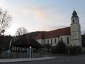
Church of hash village
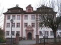
Castle of hash village
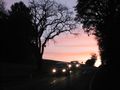
Reaching the top of the hills
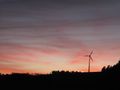
A view near the hash
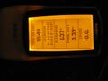
Coordinates reached
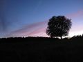
View at hash
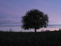
View at hash
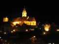
Horb at night


Achievements
- 2nd Hashiversary
- Ambassador!