Difference between revisions of "2010-11-02 33 -84"
From Geohashing
imported>NWoodruff (Created page with '{{meetup graticule | map=<map lat="33" lon="-84" date="2010-11-02" /> | lat=33 | lon=-84 | date=2010-11-02 | graticule_name=Atlanta | graticule_link=Atlanta, Georgia }} == Grat…') |
imported>NWoodruff (→Gallery) |
||
| Line 22: | Line 22: | ||
== Gallery == | == Gallery == | ||
<gallery perrow="3"> | <gallery perrow="3"> | ||
| − | Image:2010110233-84NW01.JPG | | + | Image:2010110233-84NW01.JPG | 0.11 of a mile to go from where I parked my truck. |
| + | Image:2010110233-84NW02.JPG | Mason's Mill subdivision. Abandoned more than a year ago. | ||
| + | Image:2010110233-84NW03.JPG | 2.42 feet to go. Close enough. | ||
| + | Image:2010110233-84NW04.JPG | Time of the meetup. | ||
| + | Image:2010110233-84NW05.JPG | Date of the meetup. | ||
| + | Image:2010110233-84NW06.JPG | A picture of the lot looking north standing on the Geohash spot. | ||
| + | Image:2010110233-84NW07.JPG | A picture of the actual Geohash spot. | ||
| + | Image:2010110233-84NW08.JPG | A picture looking South of the other side of the street. | ||
| + | Image:2010110233-84NW09.JPG | There was a tree across the entrance, but there was no sign posted saying "No Trespassing". | ||
| + | Image:2010110233-84NW10.JPG | I turned on the headlights of my truck trying to get a better picture. It didn't work. | ||
</gallery> | </gallery> | ||
Revision as of 12:52, 3 November 2010
| Tue 2 Nov 2010 in Atlanta: 33.7215775, -84.0695766 geohashing.info google osm bing/os kml crox |
Contents
Graticule
About
On a lot of an abandoned sub-division for houses that were never built. This is Atlanta's 200 Coordinates Reached!
Expedition
NWoodruff
Gallery
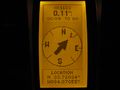
0.11 of a mile to go from where I parked my truck.
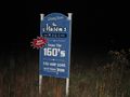
Mason's Mill subdivision. Abandoned more than a year ago.
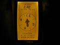
2.42 feet to go. Close enough.
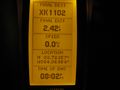
Time of the meetup.
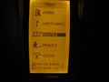
Date of the meetup.
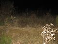
A picture of the lot looking north standing on the Geohash spot.
A picture of the actual Geohash spot.
A picture looking South of the other side of the street.
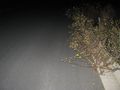
There was a tree across the entrance, but there was no sign posted saying "No Trespassing".
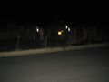
I turned on the headlights of my truck trying to get a better picture. It didn't work.


