Difference between revisions of "2010-11-06 40 -74"
imported>Jevanyn (An expedition message sent via Geohash Droid for Android.) |
imported>FippeBot m (Location) |
||
| (8 intermediate revisions by one other user not shown) | |||
| Line 1: | Line 1: | ||
| − | |||
| − | |||
| − | |||
| − | |||
| − | |||
| − | |||
| − | |||
| − | |||
| − | |||
| − | |||
{{meetup graticule | {{meetup graticule | ||
| lat=40 | | lat=40 | ||
| Line 18: | Line 8: | ||
__NOTOC__ | __NOTOC__ | ||
== Location == | == Location == | ||
| − | + | Parking lot of the Sears on NJ-35, in Middletown, New Jersey | |
== Participants == | == Participants == | ||
| − | + | [[User:Jevanyn|Jevanyn]] and Evan | |
== Plans == | == Plans == | ||
| − | + | I checked out the locations on Friday, and decided this geohash (and Friday's) were both reachable. Middletown is about an hour's drive (45 min that day actually), but I had [http://www.landsend.com Lands' End] merchandise to return to Sears anyway, so I had justification for the trip out. | |
== Expedition == | == Expedition == | ||
| − | + | After running multiple errands locally, dragging stout Evan along through store after store, I took I-287 to US-9 to NJ-35 to Middletown. The store is right on the highway, so there were no "directions" other than looking for the store and parking. | |
| − | == | + | *In the parking lot of the Sears. I'll circle around the building to get closer to the hashpoint. -- [[User:Jevanyn|Jevanyn]] [http://www.openstreetmap.org/?lat=40.40315886&lon=-74.12702958&zoom=16&layers=B000FTF @40.4032,-74.1270] 16:08, 06 November 2010 (EDT) |
| − | + | ||
| + | BTW, How does Sears stay in business? It's Saturday afternoon, [http://www.costco.com Costco] had been its usual madhouse, but employees outnumbered customers in the former retail giant. | ||
| + | |||
| + | Ironically, the smaller building 40-odd feet from the geohash was a [http://www.wendys.com Wendy's]. If I had known that, I wouldn't have sat for a crappy Costco hot dog before the drive down. Reconnaissance fail! | ||
== Photos == | == Photos == | ||
| − | + | The Geohash Droid app made it MUCH easier to post pictures the same day. I'll never go geohashing without it again! | |
| − | |||
| − | |||
<gallery perrow="5"> | <gallery perrow="5"> | ||
| − | |||
| − | == | + | Image:2010-11-06_40_-74_16-14-31-957.jpg | The Wendy's, to the east [http://www.openstreetmap.org/?lat=40.4026&lon=-74.1256&zoom=16&layers=B000FTF @40.4026,-74.1256] |
| − | + | ||
| − | + | Image:2010-11-06_40_-74_16-16-29-301.jpg | Evan, a tree, and a lamppost, to the north. [http://www.openstreetmap.org/?lat=40.4026&lon=-74.1256&zoom=16&layers=B000FTF @40.4026,-74.1256] | |
| + | Image:2010-11-06_40_-74_16-17-11-142.jpg | The Sears to our west. [http://www.openstreetmap.org/?lat=40.4026&lon=-74.1256&zoom=16&layers=B000FTF @40.4026,-74.1256] | ||
| − | + | Image:2010-11-06_40_-74_16-18-04-513.jpg | Another traffic island, and a fence in the distance, to the south. [http://www.openstreetmap.org/?lat=40.4026&lon=-74.1256&zoom=16&layers=B000FTF @40.4026,-74.1256] | |
| − | + | </gallery> | |
| − | |||
| − | + | == Achievements == | |
| − | + | (Is there an achievement for using the Droid app?) | |
| − | [[ | + | {{gratuitous ribbon |
| − | + | |latitude=40 | |
| + | |longitude=-74 | ||
| + | |date=2010-11-06 | ||
| + | |name=[[User:Jevanyn|Jevanyn]] | ||
| + | |achievement=Reconnaissance Failure Demerit | ||
| + | |color=black | ||
| + | |description=not noticing the Wendy's 40-odd feet away from the | ||
| + | |icon=PoisonIvy.PNG | ||
| + | }} | ||
| + | {{gratuitous ribbon | ||
| + | |latitude=40 | ||
| + | |longitude=-74 | ||
| + | |date=2010-11-06 | ||
| + | |name=[[User:Jevanyn|Jevanyn]] | ||
| + | |achievement=Excessive Advertising Warning | ||
| + | |color=red | ||
| + | |description=linking to the websites of all the businesses at the | ||
| + | |icon=Warning yellow.png | ||
| + | }} | ||
| − | |||
[[Category:Expeditions]] | [[Category:Expeditions]] | ||
| − | |||
[[Category:Expeditions with photos]] | [[Category:Expeditions with photos]] | ||
| − | |||
| − | |||
| − | |||
| − | |||
| − | |||
[[Category:Coordinates reached]] | [[Category:Coordinates reached]] | ||
| − | + | [[Category:Jevanyn/brought Evan]] | |
| − | + | {{location|US|NJ|MN}} | |
| − | |||
| − | [[Category: | ||
| − | |||
| − | |||
| − | |||
| − | |||
| − | |||
| − | |||
Latest revision as of 04:32, 9 August 2019
| Sat 6 Nov 2010 in 40,-74: 40.4025678, -74.1255704 geohashing.info google osm bing/os kml crox |
Location
Parking lot of the Sears on NJ-35, in Middletown, New Jersey
Participants
Jevanyn and Evan
Plans
I checked out the locations on Friday, and decided this geohash (and Friday's) were both reachable. Middletown is about an hour's drive (45 min that day actually), but I had Lands' End merchandise to return to Sears anyway, so I had justification for the trip out.
Expedition
After running multiple errands locally, dragging stout Evan along through store after store, I took I-287 to US-9 to NJ-35 to Middletown. The store is right on the highway, so there were no "directions" other than looking for the store and parking.
- In the parking lot of the Sears. I'll circle around the building to get closer to the hashpoint. -- Jevanyn @40.4032,-74.1270 16:08, 06 November 2010 (EDT)
BTW, How does Sears stay in business? It's Saturday afternoon, Costco had been its usual madhouse, but employees outnumbered customers in the former retail giant.
Ironically, the smaller building 40-odd feet from the geohash was a Wendy's. If I had known that, I wouldn't have sat for a crappy Costco hot dog before the drive down. Reconnaissance fail!
Photos
The Geohash Droid app made it MUCH easier to post pictures the same day. I'll never go geohashing without it again!
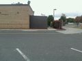
The Wendy's, to the east @40.4026,-74.1256
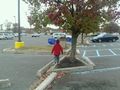
Evan, a tree, and a lamppost, to the north. @40.4026,-74.1256
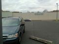
The Sears to our west. @40.4026,-74.1256
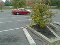
Another traffic island, and a fence in the distance, to the south. @40.4026,-74.1256


Achievements
(Is there an achievement for using the Droid app?)
Jevanyn earned the Reconnaissance Failure Demerit
|
Jevanyn earned the Excessive Advertising Warning
|