Difference between revisions of "2010-11-07 53 -1"
From Geohashing
imported>MykaDragonBlue ([live picture] It has become a bit dark now) |
imported>FippeBot m (Location) |
||
| (3 intermediate revisions by 2 users not shown) | |||
| Line 1: | Line 1: | ||
| + | {{meetup graticule|lat=53|lon=-1|date=2010-11-07}} | ||
| − | |||
| − | |||
| − | |||
| − | |||
| − | |||
| − | |||
| − | |||
| − | |||
| − | |||
| − | |||
| − | |||
| − | |||
| − | |||
| − | |||
| − | |||
| − | |||
| − | |||
== Location == | == Location == | ||
| − | + | middleton park, south of leeds | |
== Participants == | == Participants == | ||
| − | + | [[User:mykaDragonBlue|myka]] and [[User:mykaDragonBlue/Hashscot|possibly Fergus]] | |
== Plans == | == Plans == | ||
| − | + | if the bike is working ok, then ride out and find the hash. otherwise, try and figure out which buses go to roughly the right spot. | |
== Expedition == | == Expedition == | ||
| − | |||
| − | |||
*So. Hashing. | *So. Hashing. | ||
| Line 53: | Line 35: | ||
Image:2010-11-07_53_-1_16-24-04-489.jpg | Yay hashpoint [http://www.openstreetmap.org/?lat=53.7616&lon=-1.5514&zoom=16&layers=B000FTF @53.7616,-1.5514] | Image:2010-11-07_53_-1_16-24-04-489.jpg | Yay hashpoint [http://www.openstreetmap.org/?lat=53.7616&lon=-1.5514&zoom=16&layers=B000FTF @53.7616,-1.5514] | ||
| − | |||
| − | |||
Image:2010-11-07_53_-1_16-26-55-099.jpg | Night mode seems to work on this phone's camera [http://www.openstreetmap.org/?lat=53.7610&lon=-1.5513&zoom=16&layers=B000FTF @53.7610,-1.5513] | Image:2010-11-07_53_-1_16-26-55-099.jpg | Night mode seems to work on this phone's camera [http://www.openstreetmap.org/?lat=53.7610&lon=-1.5513&zoom=16&layers=B000FTF @53.7610,-1.5513] | ||
| Line 66: | Line 46: | ||
| − | |||
| − | |||
| − | |||
| − | |||
| − | |||
| − | |||
| − | |||
| − | |||
| − | |||
| − | |||
[[Category:Expeditions]] | [[Category:Expeditions]] | ||
| − | |||
[[Category:Expeditions with photos]] | [[Category:Expeditions with photos]] | ||
| − | |||
| − | |||
| − | |||
| − | |||
| − | |||
[[Category:Coordinates reached]] | [[Category:Coordinates reached]] | ||
| − | + | {{location|GB|ENG|LDS}} | |
| − | |||
| − | |||
| − | |||
| − | |||
| − | |||
| − | |||
| − | |||
| − | |||
| − | |||
Latest revision as of 04:33, 9 August 2019
| Sun 7 Nov 2010 in 53,-1: 53.7609772, -1.5510646 geohashing.info google osm bing/os kml crox |
Location
middleton park, south of leeds
Participants
myka and possibly Fergus
Plans
if the bike is working ok, then ride out and find the hash. otherwise, try and figure out which buses go to roughly the right spot.
Expedition
- So. Hashing.
I didn't think the bike would be up to it, but it appears to want to go adventuring, so i shall ride the 5 or 6 km to middleton wood. -- mykaDragonBlue [- i have no sig -] 15:23, 7 November 2010 (UTC)
- Two things
- i forgot how early it gets dark here. Lucky i have lights this time.
- i lost some fit having not ridden for a while. -- mykaDragonBlue [- i have no sig -] @53.7647,-1.5447 16:07, 7 November 2010 (UTC)
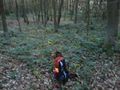
- This in not a bad wood really. I'd stay and wander around if it wasn't getting dark. Autumn colors and slightly damp and someone skulking around doing who knows what 50m further up the hill. -- mykaDragonBlue [- i have no sig -] @53.7610,-1.5463 16:36, 7 November 2010 (UTC)
Tracklog
Photos
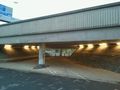
This is apparently a toucan crossing @53.7840,-1.5536
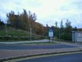
There is a wood... Sort of @53.7647,-1.5442
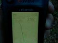
Yay hashpoint @53.7616,-1.5514
Night mode seems to work on this phone's camera @53.7610,-1.5513
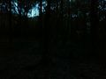
It has become a bit dark now


