Difference between revisions of "2010-11-07 59 17"
imported>Vswe |
imported>FippeBot m (Location) |
||
| (3 intermediate revisions by 2 users not shown) | |||
| Line 17: | Line 17: | ||
__NOTOC__ | __NOTOC__ | ||
== Location == | == Location == | ||
| − | + | ||
Dalby outside Uppsala | Dalby outside Uppsala | ||
| Line 28: | Line 28: | ||
| − | |||
| − | |||
== Expedition == | == Expedition == | ||
<!-- how it all turned out. your narrative goes here. --> | <!-- how it all turned out. your narrative goes here. --> | ||
| − | After putting on my XKCD t-shirt and a jacket I took my bag and my bicycle and biked the 20km to the geohash. I didn't | + | After putting on my XKCD t-shirt and a jacket I took my bag and my bicycle and biked the 20km to the geohash. I didn't |
| + | have a map nor a GPS but I had been very close to the geohash before and I had looked at the | ||
| + | location of the geohash at Google maps so when I came close it wouldn't be a problem. | ||
| + | |||
| + | But I didn't find the correct road to get to the geohash, I wasn't far away and I knew exactly where I were. But I still couldn't find the road. There were many roads but they all seemed to stop at a house, my road should've continued after a house to the geohash. So I took another road which I knew was the wrong one and parked my bike at the end of it. I should have continued on it but it was very difficult to bike on the field I was passing so therefore no bike achievement for me this time :). | ||
| + | |||
| + | After passing a field I could've continued on the next one in the same direction but I wasn't sure where I were going and I decided to make a right turn instead onto another field. I was very close to turn back to the old field and take the other way but then I saw three deer further away on the field I was standing on. I took a photo of them and then tried to get closer to get a better photo. Of course they ran away, but when I followed them I passed some trees on the field and suddenly I saw something I recognized. | ||
| + | |||
| + | This time it wasn't from above but it was surely the same area as I had seen earlier in Google maps. Thank you deer(wonder if this counts as "Beast of burden geohash achievement" :P). I went to the place where the geohash would be. I used my compass and some notes I had made earlier to take me to the geohash. | ||
| + | |||
| + | Not a perfect proof but if I wanted to make a fake proof why would I go 40km back and forth by bike to make it? :D I put out the tablecloth and ate some cookies and chocolate I brought from home but it was very cold compared to my clothing(around 0 degrees Celsius (no proof for the "Frozen Geohash" though)) so the picnic wasn't long. I juggled a bit to become warmer but it didn't helped much. To prove my circus tricks I juggled with two balls in one hand while managing the camera in the other. It wasn't easy. | ||
| + | |||
| + | After this I packed my stuff and started to make my way back. This time I though I take the planned route back since I knew where the road was. But after awhile I saw a sign that warned me of a bull. I got a bit scared because I didn't knew where he was. I quickly (after taking a picture of course) turned around and headed back the way I had come. After a few minutes walk I was back at my bike and rode it home. | ||
<!-- Nothing in this section currently > | <!-- Nothing in this section currently > | ||
| Line 42: | Line 52: | ||
== Photos == | == Photos == | ||
| − | + | ||
| − | |||
| − | |||
| − | |||
<gallery perrow="5"> | <gallery perrow="5"> | ||
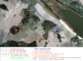
| + | Image:2010-11-07_59_17_route.png | My route. | ||
| + | Image:2010-11-07_59_17_view1.jpg | Just left my bike at those houses. | ||
| + | Image:2010-11-07_59_17_view2.jpg | Searching | ||
| + | Image:2010-11-07_59_17_deers1.jpg | Some deer... | ||
| + | Image:2010-11-07_59_17_deers2.JPG | ...escaping from me. | ||
| + | Image:2010-11-07_59_17_view4.jpg | Approaching the geohash | ||
| + | Image:2010-11-07_59_17_compass.jpg | Using a compass and some notes to find the geohash, more notes at the back of the paper. | ||
| + | Image:2010-11-07_59_17_trees.jpg | Some birches at the geohash that one can see on Google Maps. | ||
| + | Image:2010-11-07_59_17_Me.jpg | [[:Category:Grins|Stupid Grin]]<sup>tm</sup> | ||
| + | Image:2010-11-07_59_17_Date.JPG | Showing today's date on my cell(the phone, the date isn't printed on the cells in my body, or at least that's what I think) | ||
| + | Image:2010-11-07_59_17_picnic2.jpg | Yummy... | ||
| + | Image:2010-11-07_59_17_juggling1.jpg | It's difficult to juggle and operate a camera at the same time... | ||
| + | Image:2010-11-07_59_17_juggling2.jpg | ...but it works. | ||
| + | Image:2010-11-07_59_17_view5.jpg | Leaving the geohash | ||
| + | Image:2010-11-07_59_17_sign1.JPG | The "Warning for the bull" sign | ||
| + | Image:2010-11-07_59_17_sign2.JPG | Close look at the sign | ||
| + | Image:2010-11-07_59_17_bike.JPG | Back to my bike | ||
| + | {{ GalleryItem | File:2010-11-07_59_17_bike.JPG | Uppsala, Sweden | 2010-11-07 59 17 }} | ||
</gallery> | </gallery> | ||
| Line 52: | Line 77: | ||
== Achievements == | == Achievements == | ||
{{#vardefine:ribbonwidth|800px}} | {{#vardefine:ribbonwidth|800px}} | ||
| − | + | ||
{{Circus_geohash | latitude = 59 | longitude = 17 | date = 2010-11-07 | name = Vswe | performance = juggling }} | {{Circus_geohash | latitude = 59 | longitude = 17 | date = 2010-11-07 | name = Vswe | performance = juggling }} | ||
{{No_batteries_geohash | latitude = 59 | longitude = 17 | date = 2010-11-07 | name = Vswe }} | {{No_batteries_geohash | latitude = 59 | longitude = 17 | date = 2010-11-07 | name = Vswe }} | ||
{{Picnic | latitude = 59 | longitude = 17 | date = 2010-11-07 | name = Vswe | food = cookies & chocolate }} | {{Picnic | latitude = 59 | longitude = 17 | date = 2010-11-07 | name = Vswe | food = cookies & chocolate }} | ||
{{land geohash | latitude = 59 | longitude = 17 | date = 2010-11-07 | name = Vswe }} | {{land geohash | latitude = 59 | longitude = 17 | date = 2010-11-07 | name = Vswe }} | ||
| − | |||
| − | |||
| − | |||
| − | |||
| − | |||
| − | |||
| − | |||
| Line 70: | Line 88: | ||
[[Category:Expeditions with photos]] | [[Category:Expeditions with photos]] | ||
[[Category:Expedition without GPS]] | [[Category:Expedition without GPS]] | ||
| − | + | ||
| − | |||
[[Category:Coordinates reached]] | [[Category:Coordinates reached]] | ||
| + | {{location|SE|C}} | ||
Latest revision as of 04:33, 9 August 2019
| Sun 7 Nov 2010 in 59,17: 59.7609772, 17.5510646 geohashing.info google osm bing/os kml crox |
Location
Dalby outside Uppsala
Participants
- Vswe - my first time, please join me :)
Expedition
After putting on my XKCD t-shirt and a jacket I took my bag and my bicycle and biked the 20km to the geohash. I didn't have a map nor a GPS but I had been very close to the geohash before and I had looked at the location of the geohash at Google maps so when I came close it wouldn't be a problem.
But I didn't find the correct road to get to the geohash, I wasn't far away and I knew exactly where I were. But I still couldn't find the road. There were many roads but they all seemed to stop at a house, my road should've continued after a house to the geohash. So I took another road which I knew was the wrong one and parked my bike at the end of it. I should have continued on it but it was very difficult to bike on the field I was passing so therefore no bike achievement for me this time :).
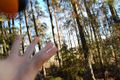
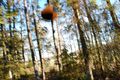
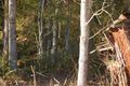
After passing a field I could've continued on the next one in the same direction but I wasn't sure where I were going and I decided to make a right turn instead onto another field. I was very close to turn back to the old field and take the other way but then I saw three deer further away on the field I was standing on. I took a photo of them and then tried to get closer to get a better photo. Of course they ran away, but when I followed them I passed some trees on the field and suddenly I saw something I recognized.
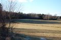
This time it wasn't from above but it was surely the same area as I had seen earlier in Google maps. Thank you deer(wonder if this counts as "Beast of burden geohash achievement" :P). I went to the place where the geohash would be. I used my compass and some notes I had made earlier to take me to the geohash.
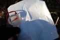
Not a perfect proof but if I wanted to make a fake proof why would I go 40km back and forth by bike to make it? :D I put out the tablecloth and ate some cookies and chocolate I brought from home but it was very cold compared to my clothing(around 0 degrees Celsius (no proof for the "Frozen Geohash" though)) so the picnic wasn't long. I juggled a bit to become warmer but it didn't helped much. To prove my circus tricks I juggled with two balls in one hand while managing the camera in the other. It wasn't easy.
After this I packed my stuff and started to make my way back. This time I though I take the planned route back since I knew where the road was. But after awhile I saw a sign that warned me of a bull. I got a bit scared because I didn't knew where he was. I quickly (after taking a picture of course) turned around and headed back the way I had come. After a few minutes walk I was back at my bike and rode it home.
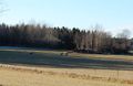
Photos
My route.
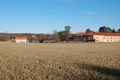
Just left my bike at those houses.
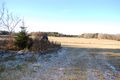
Searching
Some deer...
...escaping from me.
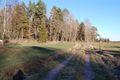
Approaching the geohash
Using a compass and some notes to find the geohash, more notes at the back of the paper.
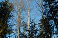
Some birches at the geohash that one can see on Google Maps.
Showing today's date on my cell(the phone, the date isn't printed on the cells in my body, or at least that's what I think)
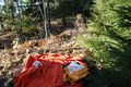
Yummy...
It's difficult to juggle and operate a camera at the same time...
...but it works.
Leaving the geohash
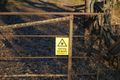
The "Warning for the bull" sign
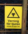
Close look at the sign
Back to my bike


Achievements
Vswe earned the Circus Geohash Achievement
|
Vswe earned the No Batteries Geohash Achievement
|
Vswe earned the Picnic achievement
|
Vswe earned the Land geohash achievement
|