Difference between revisions of "2010-11-10 39 -104"
imported>Cmanb (Created page with '<!-- If you did not specify these parameters in the template, please substitute appropriate things for IMAGE, LAT, LON, and DATE (YYYY-MM-DD format) [[Image:{{{image|IMAGE}}}|t…') |
imported>FippeBot m (Location) |
||
| (2 intermediate revisions by 2 users not shown) | |||
| Line 1: | Line 1: | ||
| − | |||
| − | |||
| − | |||
| − | |||
| − | |||
| − | |||
{{meetup graticule | {{meetup graticule | ||
| lat=39 | | lat=39 | ||
| Line 28: | Line 22: | ||
<!-- how it all turned out. your narrative goes here. --> | <!-- how it all turned out. your narrative goes here. --> | ||
| + | The only good or interesting thing about this expedition is that I reached the coordinates. | ||
| + | |||
| + | The Algorithm, in all it's mysterious wisdom, decided to drop the coords one measly block north of my homeward commute. It would have been tragic had I forgotten to look up the coordinates today and as a result miss this extremely easy hash. | ||
| + | |||
| + | I attempted to share my ride in real time using an iPhone app called Glympse. The result can be seen here [http://glympse.com/SX0-93P], but I can't really say it did what I thought it would, or that it contributed anything useful or interesting to the expedition. | ||
| + | |||
| + | So I arrived at the hash site. I recognized it spot I was looking for from the google maps satellite photos: three trees in a row at the southeast corner of the intersection. I tweeted my location while standing under the middle tree and as close to the house as I felt comfortable standing. | ||
| + | |||
| + | I took a couple pictures so one can see the landmarks present from google maps, namely the three trees by the side of the house. But the lighting was piss poor and the pictures turned out so crappy that it's not worth it to upload them here. If you are curious, they can be seen here [http://twitpic.com/35pesh] and here [http://instagr.am/p/NoZ9]. | ||
| + | Easy tag. Wish the light had been better so I could have snagged some better photos! | ||
== Photos == | == Photos == | ||
| Line 36: | Line 40: | ||
<gallery perrow="4"> | <gallery perrow="4"> | ||
Image:Planning.PNG | Pre-planning with Google Maps. | Image:Planning.PNG | Pre-planning with Google Maps. | ||
| + | Image:2010.11.10.N39.W104.iphonecoords.PNG | This is the map resulting from me tweeting my location. | ||
</gallery> | </gallery> | ||
| Line 41: | Line 46: | ||
== Achievements == | == Achievements == | ||
| − | |||
| − | |||
| − | |||
| − | |||
| − | |||
| − | |||
| − | |||
[[Category:Expeditions]] | [[Category:Expeditions]] | ||
| − | |||
[[Category:Expeditions with photos]] | [[Category:Expeditions with photos]] | ||
| − | |||
| − | |||
| − | |||
| − | |||
| − | |||
[[Category:Coordinates reached]] | [[Category:Coordinates reached]] | ||
| − | + | {{location|US|CO|DN}} | |
| − | |||
| − | |||
| − | |||
| − | |||
| − | |||
| − | |||
| − | |||
| − | |||
| − | |||
Latest revision as of 04:34, 9 August 2019
| Wed 10 Nov 2010 in 39,-104: 39.7631364, -104.9621653 geohashing.info google osm bing/os kml crox |
Location
Metro Denver in the Park Hill/5 Points area, on the corners of 33rd & Vine. Google maps places the marker right in somebody's living room. I guess my plan will be to check-in under the middle tree on the sidewalk by the house. It looks to be the closest I'll be able to get.
Participants
Plans
1. Pedal past on my way home. I'm going to try to use the glympse app that I've seen Denver Cruisers use to share my trip in real time.
Expedition
The only good or interesting thing about this expedition is that I reached the coordinates.
The Algorithm, in all it's mysterious wisdom, decided to drop the coords one measly block north of my homeward commute. It would have been tragic had I forgotten to look up the coordinates today and as a result miss this extremely easy hash.
I attempted to share my ride in real time using an iPhone app called Glympse. The result can be seen here [1], but I can't really say it did what I thought it would, or that it contributed anything useful or interesting to the expedition.
So I arrived at the hash site. I recognized it spot I was looking for from the google maps satellite photos: three trees in a row at the southeast corner of the intersection. I tweeted my location while standing under the middle tree and as close to the house as I felt comfortable standing.
I took a couple pictures so one can see the landmarks present from google maps, namely the three trees by the side of the house. But the lighting was piss poor and the pictures turned out so crappy that it's not worth it to upload them here. If you are curious, they can be seen here [2] and here [3].
Easy tag. Wish the light had been better so I could have snagged some better photos!
Photos
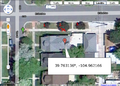
Pre-planning with Google Maps.
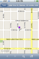
This is the map resulting from me tweeting my location.

