Difference between revisions of "2010-11-15 40 -89"
imported>Dvdllr (Created page with '{{subst:Expedition |lat = 40 |lon = -89 |date = 2010-11-15 }}') |
imported>FippeBot m (Location) |
||
| (4 intermediate revisions by one other user not shown) | |||
| Line 1: | Line 1: | ||
| − | + | __NOTOC__ | |
| − | |||
| − | |||
| − | |||
| − | |||
| − | |||
| − | |||
| − | |||
| − | |||
| − | |||
{{meetup graticule | {{meetup graticule | ||
| lat=40 | | lat=40 | ||
| Line 14: | Line 5: | ||
| date=2010-11-15 | | date=2010-11-15 | ||
}} | }} | ||
| − | |||
| − | |||
| − | |||
== Location == | == Location == | ||
| − | + | On residential road North Ardell Place on the west side of Peoria | |
== Participants == | == Participants == | ||
| − | + | * [[User:Dvdllr|Dvdllr]] & Rachel | |
== Plans == | == Plans == | ||
| − | + | Since this was the first geohash in what seemed like a while to be inside town, I thought it necessary to visit the place after work. Given that I could thoroughly explore the site beforehand with Google Street View and Bing Bird's Eye, I figured this one to be merely a drive-thru. | |
== Expedition == | == Expedition == | ||
| − | + | I kind of feel now this expedition wasn't worth the time, since it ended up being more of a chore than anything else. As I indicated, this trip ended up being only a drive-thru of the spot. I was at work later than I expected to be, and because of the stupid earth's tilted axis, it is quite early when it gets dark for the evening this time of the year. So the trip ended up being rushed and without much reward. | |
| − | + | == Photos == | |
| − | |||
| − | |||
| − | == Photos == | ||
| − | |||
| − | |||
| − | |||
<gallery perrow="5"> | <gallery perrow="5"> | ||
| + | Image:2010-11-15 40 -89 1.jpg | Exit on your left | ||
| + | Image:2010-11-15 40 -89 2.jpg | Of all six pictures attempted as I drove through the spot, this was the least blurry. And I'm going only 16 mph in a 25 zone. | ||
| + | Image:2010-11-15 40 -89 3.jpg | Intersecting roads | ||
</gallery> | </gallery> | ||
== Achievements == | == Achievements == | ||
{{#vardefine:ribbonwidth|800px}} | {{#vardefine:ribbonwidth|800px}} | ||
| − | + | {{land geohash | |
| − | + | | latitude = 40 | |
| − | + | | longitude = -89 | |
| − | + | | date = 2010-11-15 | |
| − | [[ | + | | name = [[User:Dvdllr|Dvdllr]] |
| − | + | }} | |
| − | + | {{Radio Yerevan | |
| − | + | | user = [[User:Dvdllr|Dvdllr]] | |
| − | [[ | + | | achievement = [[Speed Racer Achievement]] |
| − | -- | + | | latitude = 40 |
| − | + | | longitude = -89 | |
| − | + | | date = 2010-11-15 | |
| + | | detail = he failed to get any pictures of the GPS when it was both on the hashpoint and at the appropriate speed}} | ||
| + | |||
[[Category:Expeditions]] | [[Category:Expeditions]] | ||
| − | |||
[[Category:Expeditions with photos]] | [[Category:Expeditions with photos]] | ||
| − | |||
| − | |||
| − | |||
| − | |||
| − | |||
[[Category:Coordinates reached]] | [[Category:Coordinates reached]] | ||
| − | + | {{location|US|IL|PI}} | |
| − | |||
| − | |||
| − | |||
| − | |||
| − | |||
| − | |||
| − | |||
| − | |||
| − | |||
Latest revision as of 04:38, 9 August 2019
| Mon 15 Nov 2010 in 40,-89: 40.7159077, -89.6387643 geohashing.info google osm bing/os kml crox |
Location
On residential road North Ardell Place on the west side of Peoria
Participants
- Dvdllr & Rachel
Plans
Since this was the first geohash in what seemed like a while to be inside town, I thought it necessary to visit the place after work. Given that I could thoroughly explore the site beforehand with Google Street View and Bing Bird's Eye, I figured this one to be merely a drive-thru.
Expedition
I kind of feel now this expedition wasn't worth the time, since it ended up being more of a chore than anything else. As I indicated, this trip ended up being only a drive-thru of the spot. I was at work later than I expected to be, and because of the stupid earth's tilted axis, it is quite early when it gets dark for the evening this time of the year. So the trip ended up being rushed and without much reward.
Photos
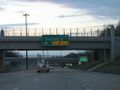
Exit on your left
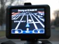
Of all six pictures attempted as I drove through the spot, this was the least blurry. And I'm going only 16 mph in a 25 zone.
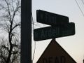
Intersecting roads


Achievements
Dvdllr earned the Land geohash achievement
|
Is it true that Dvdllr earned the Speed Racer Achievement?
|