Difference between revisions of "2010-11-17 55 13"
imported>Fasanen (Created page with '{{subst:Expedition |lat = 55 |lon = 13 |date = 2010-11-17 }}') |
imported>FippeBot m (Location) |
||
| (2 intermediate revisions by one other user not shown) | |||
| Line 1: | Line 1: | ||
| − | |||
| − | |||
| − | |||
| − | |||
| − | |||
| − | |||
| − | |||
| − | |||
| − | |||
| − | |||
{{meetup graticule | {{meetup graticule | ||
| lat=55 | | lat=55 | ||
| Line 15: | Line 5: | ||
}} | }} | ||
| − | |||
__NOTOC__ | __NOTOC__ | ||
== Location == | == Location == | ||
| − | + | Pasture in Hässleberga, [[wikipedia:Skåne|Skåne]], [[wikipedia:Sweden|Sweden]] | |
== Participants == | == Participants == | ||
| − | + | * [[User:Fasanen|Fasanen]] & Ms.C | |
== Plans == | == Plans == | ||
| − | + | Take a walk in the area of lake Eksholmssjön and make a slight detour to the hash. | |
== Expedition == | == Expedition == | ||
| − | + | Judging from aerial photos, this hashpoint seemed to be located to a not overly exciting pasture. We decided to make a small detour on the way to check out the perhaps more interesting surroundings of lake Eksholmssjön, some four kilometres south west from the hashpoint. There was a slight rain when we started our journey but the sun was able to show some faint rays when we got to Sturup airport. The hashpoint was 4 kilometres north of the runway and aligned with it, so we witnessed some aircraft in spectacular ascending angles. | |
| − | + | The coordinates were just 35 meters from the road in the pasture which was empty. Close by was another pasture with friendly sheep that greeted us loudly when we approached. I got some feelings of déjà vu when I caught a glimpse of the tower of Lyngby church behind the crest of a small hill just north from the hash point. This location was just about 1.4 kilometres from the hash coordinates close to the church that we visited [[2010-10-26_55_13 | 2010-10-26]]. After the usual documentation, we bid farewell to the sheep, returned to the car and drove off to the lake Eksholmssjön which turned out to be quite a nice conservation area. | |
| − | |||
== Photos == | == Photos == | ||
| − | |||
| − | |||
| − | |||
<gallery perrow="5"> | <gallery perrow="5"> | ||
| + | Image:201010175513 01.JPG | Proof | ||
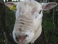
| + | Image:201010175513 02.JPG | Hail sheep! | ||
| + | Image:201010175513 03.JPG | View north | ||
| + | Image:201010175513 04.JPG | Flashback! Lyngby church tower! | ||
| + | Image:201010175513 06.JPG | Sheepish grin | ||
</gallery> | </gallery> | ||
== Achievements == | == Achievements == | ||
| − | {{ | + | {{land geohash | latitude=55 | longitude=13 | date=2010-11-17 | name=Fasanen}} |
| − | |||
| − | |||
| − | |||
| − | |||
| − | |||
| − | |||
| − | |||
| − | |||
| − | |||
| − | |||
| − | |||
| − | |||
[[Category:Expeditions]] | [[Category:Expeditions]] | ||
| − | + | [[Category:Expeditions with photos]] | |
| − | [[Category:Expeditions with photos]] | ||
| − | |||
| − | |||
| − | |||
| − | |||
| − | |||
[[Category:Coordinates reached]] | [[Category:Coordinates reached]] | ||
| − | + | {{location|SE|M}} | |
| − | |||
| − | |||
| − | |||
| − | |||
| − | |||
| − | |||
| − | |||
| − | |||
| − | |||
Latest revision as of 04:39, 9 August 2019
| Wed 17 Nov 2010 in 55,13: 55.5840567, 13.3474905 geohashing.info google osm bing/os kml crox |
Location
Pasture in Hässleberga, Skåne, Sweden
Participants
- Fasanen & Ms.C
Plans
Take a walk in the area of lake Eksholmssjön and make a slight detour to the hash.
Expedition
Judging from aerial photos, this hashpoint seemed to be located to a not overly exciting pasture. We decided to make a small detour on the way to check out the perhaps more interesting surroundings of lake Eksholmssjön, some four kilometres south west from the hashpoint. There was a slight rain when we started our journey but the sun was able to show some faint rays when we got to Sturup airport. The hashpoint was 4 kilometres north of the runway and aligned with it, so we witnessed some aircraft in spectacular ascending angles.
The coordinates were just 35 meters from the road in the pasture which was empty. Close by was another pasture with friendly sheep that greeted us loudly when we approached. I got some feelings of déjà vu when I caught a glimpse of the tower of Lyngby church behind the crest of a small hill just north from the hash point. This location was just about 1.4 kilometres from the hash coordinates close to the church that we visited 2010-10-26. After the usual documentation, we bid farewell to the sheep, returned to the car and drove off to the lake Eksholmssjön which turned out to be quite a nice conservation area.
Photos
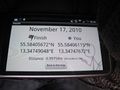
Proof
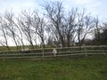
Hail sheep!
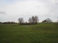
View north
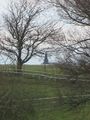
Flashback! Lyngby church tower!
Sheepish grin


Achievements
Fasanen earned the Land geohash achievement
|