Difference between revisions of "2010-11-21 49 8"
imported>Mampfred (Created page with '{{subst:Expedition |lat = 49 |lon = 8 |date = 2010-11-21 }}') |
imported>FippeBot m (Location) |
||
| (6 intermediate revisions by 2 users not shown) | |||
| Line 1: | Line 1: | ||
| − | |||
| − | |||
| − | |||
| − | |||
| − | |||
| − | |||
| − | |||
| − | |||
| − | |||
| − | |||
{{meetup graticule | {{meetup graticule | ||
| lat=49 | | lat=49 | ||
| Line 15: | Line 5: | ||
}} | }} | ||
| − | |||
| − | |||
== Location == | == Location == | ||
| − | + | Next to a sports field in Mainz. | |
== Participants == | == Participants == | ||
| − | + | *[[User:Mampfred|Mampfred]] | |
| + | *[[User:QuarterCacher|QuarterCacher]] | ||
== Plans == | == Plans == | ||
| − | + | Go there in the afternoon and visit a couple of Geocaches afterwards. | |
== Expedition == | == Expedition == | ||
| − | + | Went there, hash was pretty unspectacular in a strip of grass next to a sports field. [[User:QuarterCacher|QuarterCacher]] took a 360° panorama, which will be posted here when ready. | |
| + | |||
| + | We proceeded to do some Geocaches and actually found the first one less than 100 meters from the hash, we could actually see the hash from the cache, so that at least gives us an honorable mention. | ||
| + | |||
| + | The rest of the Geocaches: | ||
| + | *[http://coord.info/GC27JER GC27JER] - found | ||
| + | *[http://coord.info/GC14VHJ GC14VHJ] - found | ||
| + | *[http://coord.info/GC10TMN GC10TMN] - found | ||
| + | *[http://coord.info/GC2577E GC2577E] - found | ||
| + | |||
| + | In particular [http://coord.info/GC14VHJ GC14VHJ] was a bit adventurous as it was a climb Geocache. | ||
| + | We got very close to giving up before [[User:QuarterCacher|QuarterCacher]] actually spotted the Cache up in one of the trees. | ||
| + | He then decided that he couldn't take it if we got home without logging this one so | ||
| + | he had a look around the "Schrebergärten" in the area and actually found a ladder and got permission from the | ||
| + | owner to use it (Our excuse was "we accidentally threw something in a tree and want it back"). | ||
| + | |||
| + | We made sure that no-one could see us and took the ladder to the Cache. After some more climbing in the tree we got | ||
| + | it and logged it. Well done [[User:QuarterCacher|QuarterCacher]]! | ||
| + | |||
| + | And a special "Hi" goes to "The X-Mans", who actually visited all of the geocaches we did but in the opposite direction. We probably passed by them at some point but didn't notice. | ||
== Tracklog == | == Tracklog == | ||
| − | + | See [http://www.everytrail.com/view_trip.php?trip_id=890767 here]. | |
== Photos == | == Photos == | ||
| − | |||
| − | |||
| − | |||
<gallery perrow="5"> | <gallery perrow="5"> | ||
| + | Image:2010-11-21_49_8_coordinates.jpg | Coordinates ... | ||
| + | Image:2010-11-21_49_8_reached.jpg | ... reached. | ||
| + | Image:2010-11-21_49_8_map.jpg | Next to a sports field on the screen ... | ||
| + | Image:2010-11-21_49_8_sports_field.jpg | ... and in reality. | ||
| + | Image:2010-11-21_49_8_panorama.jpg |The sports field as "poor mans" panorama | ||
| + | Image:2010-11-21_49_8_jens.jpg | [[User:QuarterCacher|QuarterCacher]] taking the 360° panorama | ||
| + | Image:2010-11-21_49_8_ladder.jpg | [[User:QuarterCacher|QuarterCacher]] and the ladder for the Cache ... | ||
| + | Image:2010-11-21_49_8_tree.jpg | ... in the tree. | ||
</gallery> | </gallery> | ||
== Achievements == | == Achievements == | ||
{{#vardefine:ribbonwidth|800px}} | {{#vardefine:ribbonwidth|800px}} | ||
| − | + | {{Hash collision | |
| − | + | | latitude = 49 | |
| − | + | | longitude = 8 | |
| − | + | | date = 2010-11-21 | |
| − | + | | name = Mampfred and QuarterCacher | |
| − | [[ | + | | link = http://coord.info/GC14VHJ |
| − | + | | id = GC14VHJ | |
| − | + | | distance = 160 m | |
| − | + | | honor = jup | |
| − | [[ | + | | image = 2010-11-21_49_8_tree.jpg |
| − | -- | + | }} |
| + | {{Land geohash | ||
| + | | latitude = 49 | ||
| + | | longitude = 8 | ||
| + | | date = 2010-11-21 | ||
| + | | name = [[User:Mampfred|Mampfred]] and [[User:QuarterCacher|QuarterCacher]] | ||
| + | }} | ||
| + | {{Consecutive_geohash | ||
| + | | latitude = 50 | ||
| + | | longitude = 8 | ||
| + | | count = 2 | ||
| + | | date = 2010-11-20 | ||
| + | | name = Mampfred and QuarterCacher | ||
| + | }} | ||
| + | {{Minesweeper geohash | ||
| + | | graticule = Frankfurt am Main, Germany | ||
| + | | ranknumber = 1 | ||
| + | | s = true | ||
| + | | name = Mampfred and QuarterCacher | ||
| + | }} | ||
| − | |||
[[Category:Expeditions]] | [[Category:Expeditions]] | ||
| − | |||
[[Category:Expeditions with photos]] | [[Category:Expeditions with photos]] | ||
| − | |||
| − | |||
| − | |||
| − | |||
| − | |||
[[Category:Coordinates reached]] | [[Category:Coordinates reached]] | ||
| − | + | {{location|DE|HE|GG}} | |
| − | |||
| − | |||
| − | |||
| − | |||
| − | |||
| − | |||
| − | |||
| − | |||
| − | |||
Latest revision as of 04:41, 9 August 2019
| Sun 21 Nov 2010 in 49,8: 49.9714152, 8.3468424 geohashing.info google osm bing/os kml crox |
Location
Next to a sports field in Mainz.
Participants
Plans
Go there in the afternoon and visit a couple of Geocaches afterwards.
Expedition
Went there, hash was pretty unspectacular in a strip of grass next to a sports field. QuarterCacher took a 360° panorama, which will be posted here when ready.
We proceeded to do some Geocaches and actually found the first one less than 100 meters from the hash, we could actually see the hash from the cache, so that at least gives us an honorable mention.
The rest of the Geocaches:
In particular GC14VHJ was a bit adventurous as it was a climb Geocache. We got very close to giving up before QuarterCacher actually spotted the Cache up in one of the trees. He then decided that he couldn't take it if we got home without logging this one so he had a look around the "Schrebergärten" in the area and actually found a ladder and got permission from the owner to use it (Our excuse was "we accidentally threw something in a tree and want it back").
We made sure that no-one could see us and took the ladder to the Cache. After some more climbing in the tree we got it and logged it. Well done QuarterCacher!
And a special "Hi" goes to "The X-Mans", who actually visited all of the geocaches we did but in the opposite direction. We probably passed by them at some point but didn't notice.
Tracklog
See here.
Photos
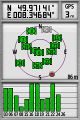
Coordinates ...
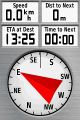
... reached.
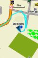
Next to a sports field on the screen ...
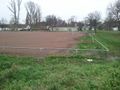
... and in reality.
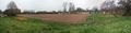
The sports field as "poor mans" panorama
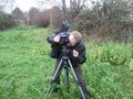
QuarterCacher taking the 360° panorama
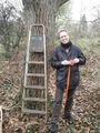
QuarterCacher and the ladder for the Cache ...
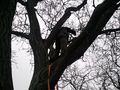
... in the tree.


Achievements
Mampfred and QuarterCacher earned the Hash collision honorable mention
|
Mampfred and QuarterCacher earned the Land geohash achievement
|
Mampfred and QuarterCacher earned the Consecutive geohash achievement
|
Mampfred and QuarterCacher achieved level 1 of the Minesweeper Geohash achievement
|