Difference between revisions of "2010-11-24 53 10"
imported>Bierhefe (→Bierhefe) |
m |
||
| (2 intermediate revisions by 2 users not shown) | |||
| Line 4: | Line 4: | ||
| date=2010-11-24 | | date=2010-11-24 | ||
| graticule_name=Hamburg (East) | | graticule_name=Hamburg (East) | ||
| − | | graticule_link=Hamburg, Germany | + | | graticule_link=Hamburg (East), Germany |
}} | }} | ||
| Line 29: | Line 29: | ||
== Tracklog == | == Tracklog == | ||
=== Bierhefe === | === Bierhefe === | ||
| − | * [http://waka.bplaced.net/geohash/2010-11-24_53_10.gpx http://waka.bplaced.net/geohash/2010-11-24_53_10.gpx] | + | * [http://waka.bplaced.net/geohash/2010-11-24_53_10.gpx http://waka.bplaced.net/geohash/2010-11-24_53_10.gpx] or on [http://www.everytrail.com/view_trip.php?trip_id=987010 everytrail] |
== Photos == | == Photos == | ||
| Line 63: | Line 63: | ||
[[Category:Expeditions with photos]] | [[Category:Expeditions with photos]] | ||
[[Category:Coordinates reached]] | [[Category:Coordinates reached]] | ||
| + | {{location|DE|SH|OD}} | ||
Latest revision as of 21:08, 26 January 2021
| Wed 24 Nov 2010 in Hamburg (East): 53.5508656, 10.1810708 geohashing.info google osm bing/os kml crox |
Location
On a muddy trail in a little town called Oststeinbek.
Participants
Expedition
Bierhefe
Okay, actually we are two persons, me and my gf. But my gf didn't have the time to go with me today, so I went to this geohash alone. This was going to be the very first Geohash I could visit. In the past few weeks there where some near my home, but just that bit too far away to get there (I'm not a very trained cyclist, plus public transportation is very limited in the eastern suburbs of Hamburg) so I was quite happy to learn that todays Geohash would be close enough to actually get there.
Well, when I got home from University I just had time to pack some things (my GPS, something to drink, some food, etc.) and to check out some nearby geocaches.
But I guess we all know it: If you are in a hurry, things will go wrong. I had to inflate my front tire first, then I had to look for my headband and some gloves (it's getting cold outside!). I found the headband about 10 minutes later, but no gloves. Ah well, it isn't THAT cold anyway... off I go! Oh wait! If I plan to bicycle there I should take my cycle with me, right? Grr...
All in all, I wasted 40 minutes to get ready, so it already was 15:40 (3:40 pm) when I finally started my journey.
Luckily I got to my destination point a lot quicker than I originally thought, so it was about 16:20 (4:20 pm) when I arrived. It seemed that nobody else had been here, so I took a picture of my hashcot and my GPS, searched for some nearby geocaches (very unsuccsesful search this time... only found one and I planned to find 5! But it was getting dark, so I actually looked for only three...).
Tracklog
Bierhefe
Photos
Bierhefe
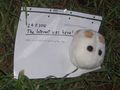
My Hashcot (a brewer's yeast, or "Bierhefe" in german ;) ) and my marker
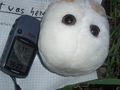
My Hashcot, my GPS (I'm off by a few yards, I guess) and my marker
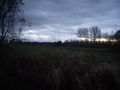
It's getting dark.
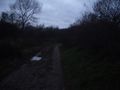
The muddy trail


Achievements
Bierhefe earned the Land geohash achievement
|
Error creating thumbnail: Unable to save thumbnail to destination |
Bierhefe earned the Bicycle geohash achievement
|
Yes, I forgot to take a picture of my bike, but once I upload the track it should be proof enough, because I went a lot faster than I could've done by foot alone (also, I'm not crazy enought to walk the whole way) but a lot slower than I could've if I went there by bus.