Difference between revisions of "2010-11-25 51 11"
imported>Mampfred (Created page with '{{subst:Expedition |lat = 51 |lon = 11 |date = 2010-11-25 }}') |
imported>FippeBot m (Location) |
||
| (9 intermediate revisions by 2 users not shown) | |||
| Line 1: | Line 1: | ||
| − | |||
| − | |||
| − | |||
| − | |||
| − | |||
| − | |||
| − | |||
| − | |||
| − | |||
| − | |||
{{meetup graticule | {{meetup graticule | ||
| lat=51 | | lat=51 | ||
| Line 15: | Line 5: | ||
}} | }} | ||
| − | |||
__NOTOC__ | __NOTOC__ | ||
== Location == | == Location == | ||
| − | + | In a field (again !) near Sömmerda. | |
== Participants == | == Participants == | ||
| − | + | *[[User:Mampfred|Mampfred]] | |
| + | *[[User:Rincewind|Rincewind]] | ||
== Plans == | == Plans == | ||
| − | + | Drive there after work and have a picnic. | |
| + | |||
| + | "What, you say it's too dark after work to have a picnic AND it's gonna be snowing tonight? I don't care, I want the picnic achievement" - [[User:Rincewind|Rincewind]] | ||
== Expedition == | == Expedition == | ||
| − | + | Let's see, we started off around 7 pm and went to a local supermarket first to get some stuff for the picnic. We ended up with some Leberkäsebrötchen, Chocolate-Puddings and (most important) beer. We also made a quick stop at [[User:Rincewind|Rincewind]]s place to get a blanket and some cuttlery. | |
| + | |||
| + | The hash turned out to be a couple of hundred meters off a "road" through the village (settlement?) and then through fields. The road changed from concrete to unmade, muddy grass road and back spontaneously at one point. We drove as far as we could (thank god for four-wheel-drive) and alternately waded through wet grass and/or sticky mud. The hash itself was unspectacular, we took a photo and moved on to a strip of grass a couple of meter further on. | ||
| + | |||
| + | We then proceeded to have our picnic in the pitch black and with a little snow to keep us company. | ||
| + | |||
| + | (It was very scenic, I have no idea what [[User:Mampfred|Mampfred]] whines about. The food was even remotely warm, still. And it wasn't even a frozen hash as we had still about 0.5°C and it was only SLIGHTLY wet ... Apart from that, the mud in that place has industrial glue-strength, if anyone wants to exploit that fact. I'm dreadfully looking towards the near future containing shoe cleaning. - [[User:Rincewind|Rincewind]]) | ||
| + | |||
| + | "We HAVE to change the rules for the picnic achievement to make sunshine a must criteria ..." - [[User:Mampfred|Mampfred]] | ||
== Tracklog == | == Tracklog == | ||
| − | + | See [http://www.everytrail.com/view_trip.php?trip_id=894628 here]. | |
== Photos == | == Photos == | ||
| − | |||
| − | |||
| − | |||
<gallery perrow="5"> | <gallery perrow="5"> | ||
| + | Image:2010-11-25_51_11_snowflake.jpg | Snowflake. In the snow. | ||
| + | Image:2010-11-25_51_11_food_cooker.jpg | Innovative food cooking for the win. | ||
| + | Image:2010-11-25_51_11_perparations.jpg | Preparations. In the snow. | ||
| + | Image:2010-11-25_51_11_farming_equipment.jpg | Some farming equipment along the way. In the snow. | ||
| + | Image:2010-11-25_51_11_coordinates.jpg | Coordinates ... | ||
| + | Image:2010-11-25_51_11_reached.jpg | ... reached. In the snow. | ||
| + | Image:2010-11-25_51_11_hash.jpg | The hash, can you see it? No snow? | ||
| + | Image:2010-11-25_51_11_picnic.jpg | Should qualify for the [[Picnic achievement]]. In the snow. | ||
| + | Image:2010-11-25_51_11_rincewind.jpg | Enjoying the picnic. In the snow. | ||
| + | Image:2010-11-25_51_11_stupid_flash_grin.jpg | Stupid <strike>grin</strike> ... flash! In the snow. | ||
| + | Image:2010-11-25_51_11_dirt.jpg | Dirt was just one of our problems. | ||
| + | Image:2010-11-25_51_11_erfurt.jpg | Erfurt ... | ||
| + | Image:2010-11-25_51_11_at_night.jpg | ... at night. In the snow. | ||
</gallery> | </gallery> | ||
== Achievements == | == Achievements == | ||
{{#vardefine:ribbonwidth|800px}} | {{#vardefine:ribbonwidth|800px}} | ||
| − | + | {{Picnic geohash | |
| − | + | | latitude = 51 | |
| − | + | | longitude = 11 | |
| − | + | | date = 2010-11-25 | |
| − | + | | name = [[User:Mampfred|Mampfred]] and [[User:Rincewind|Rincewind]] | |
| − | [[ | + | }} |
| − | + | {{Minesweeper geohash | |
| − | + | | graticule = Erfurt, Germany | |
| − | + | | ranknumber = 2 | |
| − | [[ | + | | w = true |
| − | + | | n = true | |
| + | | name = Mampfred and Rincewind | ||
| + | }} | ||
| + | {{Land geohash | ||
| + | | latitude = 51 | ||
| + | | longitude = 11 | ||
| + | | date = 2010-11-25 | ||
| + | | name = [[User:Mampfred|Mampfred]] and [[User:Rincewind|Rincewind]] | ||
| + | }} | ||
| − | |||
[[Category:Expeditions]] | [[Category:Expeditions]] | ||
| − | |||
[[Category:Expeditions with photos]] | [[Category:Expeditions with photos]] | ||
| − | |||
| − | |||
| − | |||
| − | |||
| − | |||
[[Category:Coordinates reached]] | [[Category:Coordinates reached]] | ||
| − | + | {{location|DE|TH|SÖM}} | |
| − | |||
| − | |||
| − | |||
| − | |||
| − | |||
| − | |||
| − | |||
| − | |||
| − | |||
Latest revision as of 04:44, 9 August 2019
| Thu 25 Nov 2010 in 51,11: 51.1533829, 11.2176960 geohashing.info google osm bing/os kml crox |
Location
In a field (again !) near Sömmerda.
Participants
Plans
Drive there after work and have a picnic.
"What, you say it's too dark after work to have a picnic AND it's gonna be snowing tonight? I don't care, I want the picnic achievement" - Rincewind
Expedition
Let's see, we started off around 7 pm and went to a local supermarket first to get some stuff for the picnic. We ended up with some Leberkäsebrötchen, Chocolate-Puddings and (most important) beer. We also made a quick stop at Rincewinds place to get a blanket and some cuttlery.
The hash turned out to be a couple of hundred meters off a "road" through the village (settlement?) and then through fields. The road changed from concrete to unmade, muddy grass road and back spontaneously at one point. We drove as far as we could (thank god for four-wheel-drive) and alternately waded through wet grass and/or sticky mud. The hash itself was unspectacular, we took a photo and moved on to a strip of grass a couple of meter further on.
We then proceeded to have our picnic in the pitch black and with a little snow to keep us company.
(It was very scenic, I have no idea what Mampfred whines about. The food was even remotely warm, still. And it wasn't even a frozen hash as we had still about 0.5°C and it was only SLIGHTLY wet ... Apart from that, the mud in that place has industrial glue-strength, if anyone wants to exploit that fact. I'm dreadfully looking towards the near future containing shoe cleaning. - Rincewind)
"We HAVE to change the rules for the picnic achievement to make sunshine a must criteria ..." - Mampfred
Tracklog
See here.
Photos

Snowflake. In the snow.
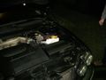
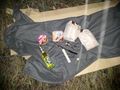
Innovative food cooking for the win.
Preparations. In the snow.
Some farming equipment along the way. In the snow.
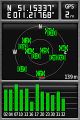
Coordinates ...
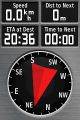
... reached. In the snow.
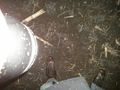
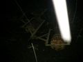
The hash, can you see it? No snow?
Should qualify for the Picnic achievement. In the snow.
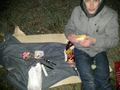
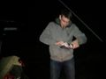
Enjoying the picnic. In the snow.
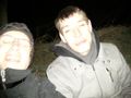
Stupid
grin... flash! In the snow.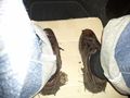
Dirt was just one of our problems.
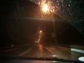
Erfurt ...
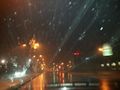
... at night. In the snow.


Achievements
Mampfred and Rincewind earned the Picnic achievement
|
Mampfred and Rincewind achieved level 2 of the Minesweeper Geohash achievement
|
Mampfred and Rincewind earned the Land geohash achievement
|