Difference between revisions of "2010-12-07 59 17"
imported>Vswe (Hashtime!) |
imported>FippeBot m (Location) |
||
| (8 intermediate revisions by one other user not shown) | |||
| Line 15: | Line 15: | ||
*School ends at 10:30. | *School ends at 10:30. | ||
*Two options here: | *Two options here: | ||
| − | #Wait until 11:00 to eat lunch in school or | + | #<s>Wait until 11:00 to eat lunch in school or</s> |
#Skip lunch(or eat it somewhere else) to be able to catch an earlier bus. | #Skip lunch(or eat it somewhere else) to be able to catch an earlier bus. | ||
*Head down to the train station by the city bus(goes every 10/15 minute). | *Head down to the train station by the city bus(goes every 10/15 minute). | ||
| Line 23: | Line 23: | ||
*After another 15 minutes I'll get off the bus. | *After another 15 minutes I'll get off the bus. | ||
*About 30 minutes walk to the geohash. | *About 30 minutes walk to the geohash. | ||
| − | *After doing all the hash thingys walk back, then bus 895 then bus 804 then walk home. | + | *After doing all the hash thingys walk back, then bus 895 <s>then bus 804</s> [bus 895 will go all the way back to the train station] then walk home. |
== Expedition == | == Expedition == | ||
| + | After school I took a city bus to the train station, just like the plans. There I bought a 20 time ticket for an even better price(the one I planned to buy didn't existed somehow). Then I took bus 804 and switched to bus 895, just as planned. However when going by bus 895 I noticed how often it stopped, there were bus stops almost everywhere. When I checked earlier online it said there only was a few of them. Now I had to decide if I should stick to the plans or going off at a later bus stop allowing me to take an earlier bus home. However, if I chose the second option I would only have to walk a total distance of 1 km and the whole trip would consist of 90 minutes by bus and 30 minutes by foot. Therefore I chose the first one: stick to the plan. | ||
| + | After walking about two and a half kilometer I arrived at the snowy field and easily found the hashpoint. Hurray! Took some pictures and celebrated by eating a [[User:Vswe#Fun_stuff|gingerbread geohasher]]. Afterwards I headed back and after another two and a half kilometer reached the bus stop I planned to catch the bus on. It was about an hour until the bus would arrive though. While I waited I ate some day-old winter-cold home-made left-over pizza-slices. Then I started to get cold myself so I started walking. When I finally got on the bus it was almost dark. It had been excellent weather all the time and I had walked a total distance of 10 km. A wonderful trip. | ||
| + | == Tracklog == | ||
| + | Tracklog[http://maps.google.com/maps/ms?ie=UTF8&hl=sv&msa=0&msid=110921429028229839370.000496d5219281c0431b7&ll=59.755012,17.554092&spn=0.271848,0.617294&z=11] | ||
| + | == Photos == | ||
| + | <gallery perrow="5"> | ||
| + | Image:2010-12-07_59_17_me1.jpg | Me at the first bus. | ||
| + | Image:2010-12-07_59_17_me2.jpg | And at the second bus. | ||
| + | Image:2010-12-07_59_17_view1.jpg | Leaving the bus making the rest of the way by foot. | ||
| + | Image:2010-12-07_59_17_view2.jpg | The snow made it look wonderful. | ||
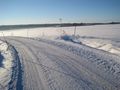
| + | Image:2010-12-07_59_17_view3.jpg | Doesn't it look nice? | ||
| + | Image:2010-12-07_59_17_view4.jpg | Onto the small road... | ||
| + | Image:2010-12-07_59_17_GPS1.jpg | Now I'm not far away. | ||
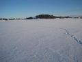
| + | Image:2010-12-07_59_17_view5.jpg | It's somewhere on that field. | ||
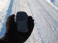
| + | Image:2010-12-07_59_17_GPS2.jpg | Approaching... | ||
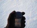
| + | Image:2010-12-07_59_17_GPS3.jpg | Proof for reaching the geohash. 0 meters to go. | ||
| + | Image:2010-12-07_59_17_me3.jpg | [[:Category:Grins|Stupid Grin]]<sup>tm</sup> | ||
| + | Image:2010-12-07_59_17_me4.jpg | The actual hashpoint. | ||
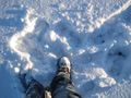
| + | Image:2010-12-07_59_17_view6.jpg | My not so straight tracks to the hash. | ||
| + | Image:2010-12-07_59_17_me5.jpg | Enjoying a [[User:Vswe#Fun_stuff|gingerbread geohasher]], still at the hash. | ||
| + | Image:2010-12-07_59_17_view7.jpg | Back to the bus stop. | ||
| + | Image:2010-12-07_59_17_pizza.jpg | PIZZA! | ||
| + | Image:2010-12-07_59_17_view8.jpg | The bus stop I finally stopped at. A nice sunset. | ||
| + | </gallery> | ||
| + | == Achievements == | ||
| + | {{#vardefine:ribbonwidth|800px}} | ||
| + | {{Public transport geohash | latitude = 59 | longitude = 17 | date = 2010-12-07 | busline = bus 804 and 895| name = Vswe}} | ||
| + | {{land geohash | latitude = 59 | longitude = 17 | date = 2010-12-07 | name = Vswe }} | ||
| − | [[Category: | + | [[Category:Expeditions]] |
| + | [[Category:Expeditions with photos]] | ||
| + | [[Category:Coordinates reached]] | ||
| + | {{location|SE|C}} | ||
Latest revision as of 04:51, 9 August 2019
| Tue 7 Dec 2010 in 59,17: 59.6332503, 17.4608869 geohashing.info google osm bing/os kml crox |
Location
In a field outside Uppsala, near Bålsta. It's not in a forest this time! :O
Participants
Plans
- School ends at 10:30.
- Two options here:
Wait until 11:00 to eat lunch in school or- Skip lunch(or eat it somewhere else) to be able to catch an earlier bus.
- Head down to the train station by the city bus(goes every 10/15 minute).
- Buy a 10 times ticket for a good price, don't know exactly where though.
- Then take bus 804 at 11:10 or 12:40 depending on where I ate lunch. 11:10 suits better though.
- After 30 minutes I have to change bus to bus number 895.
- After another 15 minutes I'll get off the bus.
- About 30 minutes walk to the geohash.
- After doing all the hash thingys walk back, then bus 895
then bus 804[bus 895 will go all the way back to the train station] then walk home.
Expedition
After school I took a city bus to the train station, just like the plans. There I bought a 20 time ticket for an even better price(the one I planned to buy didn't existed somehow). Then I took bus 804 and switched to bus 895, just as planned. However when going by bus 895 I noticed how often it stopped, there were bus stops almost everywhere. When I checked earlier online it said there only was a few of them. Now I had to decide if I should stick to the plans or going off at a later bus stop allowing me to take an earlier bus home. However, if I chose the second option I would only have to walk a total distance of 1 km and the whole trip would consist of 90 minutes by bus and 30 minutes by foot. Therefore I chose the first one: stick to the plan.
After walking about two and a half kilometer I arrived at the snowy field and easily found the hashpoint. Hurray! Took some pictures and celebrated by eating a gingerbread geohasher. Afterwards I headed back and after another two and a half kilometer reached the bus stop I planned to catch the bus on. It was about an hour until the bus would arrive though. While I waited I ate some day-old winter-cold home-made left-over pizza-slices. Then I started to get cold myself so I started walking. When I finally got on the bus it was almost dark. It had been excellent weather all the time and I had walked a total distance of 10 km. A wonderful trip.
Tracklog
Tracklog[1]
Photos

Me at the first bus.
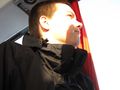
And at the second bus.
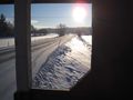
Leaving the bus making the rest of the way by foot.
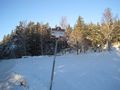
The snow made it look wonderful.
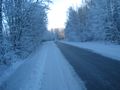
Doesn't it look nice?
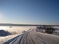
Onto the small road...
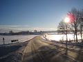
Now I'm not far away.
It's somewhere on that field.
Approaching...
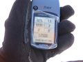
Proof for reaching the geohash. 0 meters to go.
The actual hashpoint.
My not so straight tracks to the hash.
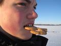
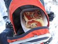
Enjoying a gingerbread geohasher, still at the hash.
Back to the bus stop.
PIZZA!
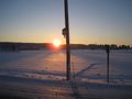
The bus stop I finally stopped at. A nice sunset.


Achievements
Vswe earned the Public transport geohash achievement
|
Vswe earned the Land geohash achievement
|