Difference between revisions of "2010-12-12 47 8"
imported>TheOneRing (Created page with '{{meetup graticule | lat=47 | lon=8 | date=2010-12-12 }} == The Place == The hashpoint is in Bassersdorf near Zürich. == The Plan == === The OneRing === Unfortunately I have t…') |
imported>FippeBot m (Location) |
||
| (8 intermediate revisions by 3 users not shown) | |||
| Line 6: | Line 6: | ||
== The Place == | == The Place == | ||
| − | The | + | The geohash is in Bassersdorf near Zürich. |
| − | == The | + | == Who Went == |
| + | [[User:TheOneRing|TheOneRing]] - by public transport. | ||
| + | |||
| + | == The Expedition == | ||
=== The OneRing === | === The OneRing === | ||
| − | + | I decided to go by train to [[Zürich, Switzerland]] and from there with another train to Bassersdorf. The village itself is near the airport "Zürich-Kloten" which I recognized immediately, because every minute a plane was starting and flew over me. After arriving at the train station in Bassersdorf the geohash was approx. 2km inside the village. On the way I saw a cat but it ran away from me so I could not pet it. Finally the geohash was located on a hill, not on top but on a hillside. It was marked with a great flag of Switzerland, which stand 5m next to the geohash. The countryside was not very attractive and after taking the usual photos I left the place. | |
| + | |||
| + | == Photos == | ||
| + | <gallery perrow="5"> | ||
| + | Image:20101212Train1.jpg|The train to Bassersdorf | ||
| + | Image:20101212TrainStation.jpg|The train station of Bassersdorf | ||
| + | Image:MeplusFlag.jpg|Non-stupid grin (Swiss flag in the background) | ||
| + | Image:20101212hashpoint.jpg|The tripod marks the geohash (or maybe it is the Apple tree) | ||
| + | Image:20101212GPS.jpg|The proof that I reached the right coordinates... | ||
| + | Image:20101212Date.jpg|...at the right date | ||
| + | Image:20101212SwissFlag.jpg|A great Flag of Switzerland at the geohash | ||
| + | Image:20101212Surrounding.jpg|The hill where the geohash is located | ||
| + | Image:20101212Train2.jpg|The train back to Zürich | ||
| + | </gallery> | ||
| + | |||
| + | == Achievements == | ||
| + | {{land geohash | latitude = 47 | longitude = 8 | date = 2010-12-12 | name = TheOneRing}} | ||
| + | {{Public transport geohash | latitude = 47 | longitude = 8 | date = 2010-12-12 |name = TheOneRing}} | ||
| + | {{Minesweeper geohash | graticule = Bern, Switzerland | ranknumber = 1 | ne = true | name = TheOneRing }} | ||
| + | |||
| + | [[Category:Expeditions]] | ||
| + | [[Category:Expeditions with photos]] | ||
| + | [[Category:Coordinates reached]] | ||
| + | {{location|CH|ZH}} | ||
Latest revision as of 04:54, 9 August 2019
| Sun 12 Dec 2010 in 47,8: 47.4447425, 8.6258899 geohashing.info google osm bing/os kml crox |
The Place
The geohash is in Bassersdorf near Zürich.
Who Went
TheOneRing - by public transport.
The Expedition
The OneRing
I decided to go by train to Zürich, Switzerland and from there with another train to Bassersdorf. The village itself is near the airport "Zürich-Kloten" which I recognized immediately, because every minute a plane was starting and flew over me. After arriving at the train station in Bassersdorf the geohash was approx. 2km inside the village. On the way I saw a cat but it ran away from me so I could not pet it. Finally the geohash was located on a hill, not on top but on a hillside. It was marked with a great flag of Switzerland, which stand 5m next to the geohash. The countryside was not very attractive and after taking the usual photos I left the place.
Photos
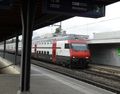
The train to Bassersdorf
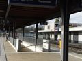
The train station of Bassersdorf

Non-stupid grin (Swiss flag in the background)
The tripod marks the geohash (or maybe it is the Apple tree)
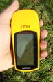
The proof that I reached the right coordinates...
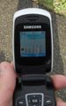
...at the right date
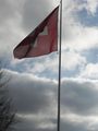
A great Flag of Switzerland at the geohash
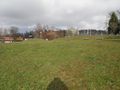
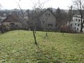
The hill where the geohash is located
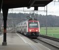
The train back to Zürich


Achievements
TheOneRing earned the Land geohash achievement
|
TheOneRing earned the Public transport geohash achievement
|
TheOneRing achieved level 1 of the Minesweeper Geohash achievement
|