Difference between revisions of "2010-12-15 49 8"
From Geohashing
imported>Ryo (An expedition message sent via Geohash Droid for Android.) |
imported>FippeBot m (Location) |
||
| (8 intermediate revisions by 2 users not shown) | |||
| Line 1: | Line 1: | ||
| − | |||
<!-- If you did not specify these parameters in the template, please substitute appropriate values for IMAGE, LAT, LON, and DATE (YYYY-MM-DD format) | <!-- If you did not specify these parameters in the template, please substitute appropriate values for IMAGE, LAT, LON, and DATE (YYYY-MM-DD format) | ||
| Line 15: | Line 14: | ||
}} | }} | ||
| − | + | ||
__NOTOC__ | __NOTOC__ | ||
== Location == | == Location == | ||
| − | + | ||
| + | Field near Kirschgartshausen | ||
== Participants == | == Participants == | ||
| − | + | ||
| + | * [[user:Ryo|Ryo]] | ||
== Plans == | == Plans == | ||
| − | + | ||
| + | No plans... just had the idea and off I went. | ||
== Expedition == | == Expedition == | ||
| − | |||
| − | + | I spontaneously went there. It began to snow and the wide open field looked like a winter-wonderland. | |
| − | + | Luckily the ground was frozen. | |
| + | |||
| + | Pretty straightforward and fun with the written sign left there. | ||
| + | |||
== Photos == | == Photos == | ||
| − | + | ||
| − | + | ||
| − | |||
<gallery perrow="5"> | <gallery perrow="5"> | ||
| + | |||
| + | Image:2010-12-15_49_8_16-08-44-828.jpg | At an field near Kirschgartshausen [http://www.openstreetmap.org/?lat=49.580912590026855&lon=8.462090492248535&zoom=16&layers=B000FTF @49.5809,8.4621] | ||
| + | |||
| + | Image:2010-12-15_49_8_16-12-06-054.jpg | Field near Kirschgartshausen | ||
</gallery> | </gallery> | ||
== Achievements == | == Achievements == | ||
{{#vardefine:ribbonwidth|800px}} | {{#vardefine:ribbonwidth|800px}} | ||
| − | |||
| + | * Land geohash | ||
| − | |||
| − | |||
| − | |||
| − | + | [[Category:Expeditions]] | |
| − | |||
| − | [[Category: | ||
| − | |||
| − | |||
| − | |||
| − | |||
[[Category:Expeditions with photos]] | [[Category:Expeditions with photos]] | ||
| − | |||
| − | |||
| − | |||
| − | |||
| − | |||
[[Category:Coordinates reached]] | [[Category:Coordinates reached]] | ||
| − | + | {{location|DE|BW|MA}} | |
| − | |||
| − | |||
| − | |||
| − | |||
| − | |||
| − | |||
| − | |||
| − | |||
| − | |||
Latest revision as of 04:56, 9 August 2019
| Wed 15 Dec 2010 in 49,8: 49.5809127, 8.4620689 geohashing.info google osm bing/os kml crox |
Location
Field near Kirschgartshausen
Participants
Plans
No plans... just had the idea and off I went.
Expedition
I spontaneously went there. It began to snow and the wide open field looked like a winter-wonderland. Luckily the ground was frozen.
Pretty straightforward and fun with the written sign left there.
Photos
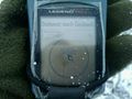
At an field near Kirschgartshausen @49.5809,8.4621
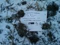
Field near Kirschgartshausen


Achievements
- Land geohash