Difference between revisions of "2010-12-24 43 -124"
From Geohashing
imported>Michael5000 m |
m (per Renaming Proposal) |
||
| (4 intermediate revisions by 3 users not shown) | |||
| Line 7: | Line 7: | ||
}} | }} | ||
| − | + | ||
__NOTOC__ | __NOTOC__ | ||
== Location == | == Location == | ||
| Line 20: | Line 20: | ||
== Expedition == | == Expedition == | ||
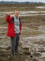
| − | Our second annual attempt to hash the Coos Bay | + | Our second annual attempt to hash the Coos Bay graticule was a success! We had looked at the hashpoint before starting our Christmas trip, so we knew to bring heavy boots. Checking the tide table before setting out, this adventure turned out to require nothing more arduous than a half hour drive following by squelching out into thick tidal mud. |
== Photos == | == Photos == | ||
| Line 33: | Line 33: | ||
== Achievements == | == Achievements == | ||
{{#vardefine:ribbonwidth|800px}} | {{#vardefine:ribbonwidth|800px}} | ||
| − | + | ||
| − | {{ | + | * Land Geohash |
| + | |||
| + | {{Graticule unlocked | ||
| latitude = 43 | | latitude = 43 | ||
| longitude = -124 | | longitude = -124 | ||
| date = 2010-12-24 | | date = 2010-12-24 | ||
| name = [[User:Michael5000|Michael5000]] & [[User:Mrs.5000|Mrs.5000]] | | name = [[User:Michael5000|Michael5000]] & [[User:Mrs.5000|Mrs.5000]] | ||
| − | | image = | + | | image = 2010-12-24 43 -124 group photo.jpg |
}} | }} | ||
| − | |||
| − | |||
[[Category:Expeditions]] | [[Category:Expeditions]] | ||
| Line 51: | Line 51: | ||
[[Category:Coordinates reached]] | [[Category:Coordinates reached]] | ||
| + | {{location|US|OR|CO}} | ||
Latest revision as of 05:59, 20 March 2024

| Fri 24 Dec 2010 in 43,-124: 43.3753123, -124.1643310 geohashing.info google osm bing/os kml crox |
Location
In a tidal flat just off of East Bay Drive.
Participants
Expedition
Our second annual attempt to hash the Coos Bay graticule was a success! We had looked at the hashpoint before starting our Christmas trip, so we knew to bring heavy boots. Checking the tide table before setting out, this adventure turned out to require nothing more arduous than a half hour drive following by squelching out into thick tidal mud.
Photos
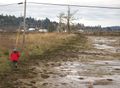
Approaching the hashpoint.
This is the place.

Team photo.


Achievements
- Land Geohash
Michael5000 & Mrs.5000 earned the Graticule Unlocked Achievement
|