Difference between revisions of "2011-01-15 35 -106"
From Geohashing
imported>Redaragorn (Created page with "{{meetup graticule | lat=35 | lon=-106 | date=2011-01-15 }} == Location == Steep terrain on the south side of Sandia, not more than a quarter mile from the [http://www.examiner...") |
imported>FippeBot m (Location) |
||
| Line 38: | Line 38: | ||
[[Category:Expeditions]] | [[Category:Expeditions]] | ||
[[Category:Coordinates reached]] | [[Category:Coordinates reached]] | ||
| + | {{location|US|NM|BE}} | ||
Latest revision as of 05:13, 9 August 2019
| Sat 15 Jan 2011 in 35,-106: 35.0734244, -106.4637741 geohashing.info google osm bing/os kml crox |
Location
Steep terrain on the south side of Sandia, not more than a quarter mile from the Eye of the Sandias.
Participants
Plans
I can't hardly let another hash on Sandia go to waste. This one is near the interesting, quirky Eye of the Sandias. I've done that hike before, and although it is moderately steep, it's not terribly long. I'm thinking I'll take the boy along and hope that the steep bushwhack isn't TOO unreasonable.
Expedition
Track
The track is located here.
Pictures
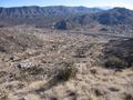
View of the neighborhood below the hash, and the Manzanita Mountains to the south.

Me grinning at the hash.
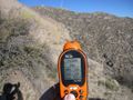
GPS coordinates with Sandia in the background.


