Difference between revisions of "2011-01-17 48 8"
From Geohashing
imported>Ekorren (Been there. Report still to be done.) |
imported>FippeBot m (Location) |
||
| (One intermediate revision by one other user not shown) | |||
| Line 20: | Line 20: | ||
<gallery> | <gallery> | ||
| + | File:2011-01-17 48 8 detour.jpg|Detour ahead (OSM actually knew there was a gap. Google didn't.) | ||
| + | File:2011-01-17 48 8 track.jpg|This way | ||
| + | File:2011-01-17 48 8 drive in.jpg|Years ago, someone tried a preemptive drive in hash | ||
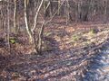
| + | File:2011-01-17 48 8 Hashpoint.jpg|The actual hashpoint | ||
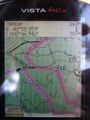
| + | File:2011-01-17 48 8 GPS.jpg|Coordinates reached | ||
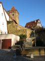
| + | File:2011-01-17 48 8 Oetisheim 2.jpg|Ötisheim (hash village) | ||
| + | File:2011-01-17 48 8 Oetisheim 1.jpg| | ||
</gallery> | </gallery> | ||
| Line 26: | Line 33: | ||
[[Category:Expeditions with photos]] | [[Category:Expeditions with photos]] | ||
[[Category:Coordinates reached]] | [[Category:Coordinates reached]] | ||
| + | {{location|DE|BW|PF}} | ||
Latest revision as of 05:15, 9 August 2019
| Mon 17 Jan 2011 in 48,8: 48.9771560, 8.7823476 geohashing.info google osm bing/os kml crox |
Contents
Location
In a forest between Ötisheim, Ölbronn and Maulbronn
Participants
Expedition
Did a detour on the way home from Heidelberg, by bike from Ölbronn to Mühlacker.
Gallery
Detour ahead (OSM actually knew there was a gap. Google didn't.)
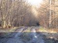
This way
Years ago, someone tried a preemptive drive in hash
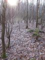
The actual hashpoint
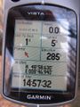
Coordinates reached
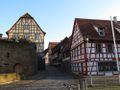
Ötisheim (hash village)