Difference between revisions of "2011-01-21 53 9"
From Geohashing
imported>Hermann (→Photos) |
imported>Hermann (wrote everything) |
||
| Line 1: | Line 1: | ||
| − | |||
| − | |||
| − | |||
| − | |||
| − | |||
| − | |||
| − | |||
| − | |||
| − | |||
| − | |||
{{meetup graticule | {{meetup graticule | ||
| lat=53 | | lat=53 | ||
| Line 14: | Line 4: | ||
| date=2011-01-21 | | date=2011-01-21 | ||
}} | }} | ||
| − | |||
| − | |||
__NOTOC__ | __NOTOC__ | ||
== Location == | == Location == | ||
| − | + | An apple farm near "Buxtehude". | |
== Participants == | == Participants == | ||
| − | + | [[User:Hermann|Hermann]] played puppet master talking a fellow student to visit the hash for him. | |
| − | |||
| − | |||
| − | |||
== Expedition == | == Expedition == | ||
| − | + | === [[User:Hermann|Hermann]] === | |
| − | + | When I showed him the location of the hash a friend of mine exclamed: "How do ''they'' know where I am living?" He was willing to take photos of the hash, but he has no GPS device. Bing Maps supplies a high resolution [http://www.bing.com/maps/default.aspx?v=2&cp=53.5010444~9.7825491&lvl=18&style=b birds eye view] of the hash. You almost can make out the individual apples. | |
| − | == | ||
| − | |||
| − | |||
== Photos == | == Photos == | ||
<gallery perrow="3"> | <gallery perrow="3"> | ||
| − | File:Hermann_Geohash_2011-01-28_53_9_P1040319.jpg|The hash is | + | File:Hermann_Geohash_2011-01-28_53_9_P1040319.jpg|The hash is there ... |
| − | File:Hermann_Geohash_2011-01-28_53_9_P1040320.jpg|... or | + | File:Hermann_Geohash_2011-01-28_53_9_P1040320.jpg|... or over there ... |
| − | File:Hermann_Geohash_2011-01-28_53_9_P1040321.jpg|... or rather | + | File:Hermann_Geohash_2011-01-28_53_9_P1040321.jpg|... or rather there . |
</gallery> | </gallery> | ||
== Achievements == | == Achievements == | ||
{{#vardefine:ribbonwidth|800px}} | {{#vardefine:ribbonwidth|800px}} | ||
| − | + | {{Puppet Master Geohash | |
| − | + | | latitude = 53 | |
| − | + | | longitude = 9 | |
| − | + | | date = 2011-01-28 | |
| − | + | | puppet = a fellow student | |
| − | [[ | + | | name = [[User:Hermann|Hermann]] |
| + | }} | ||
| − | |||
| − | |||
| − | |||
| − | |||
| − | |||
| − | |||
[[Category:Expeditions]] | [[Category:Expeditions]] | ||
| − | |||
[[Category:Expeditions with photos]] | [[Category:Expeditions with photos]] | ||
| − | |||
[[Category:Expedition without GPS]] | [[Category:Expedition without GPS]] | ||
| − | |||
| − | |||
| − | |||
| − | |||
| − | |||
| − | |||
| − | |||
[[Category:Coordinates not reached]] | [[Category:Coordinates not reached]] | ||
| − | + | [[Category:Not reached - No public access]] | |
| − | |||
| − | [[Category:Not reached - No public access]] | ||
| − | |||
| − | |||
| − | |||
Revision as of 13:03, 29 January 2011
| Fri 21 Jan 2011 in 53,9: 53.5010444, 9.7825491 geohashing.info google osm bing/os kml crox |
Location
An apple farm near "Buxtehude".
Participants
Hermann played puppet master talking a fellow student to visit the hash for him.
Expedition
Hermann
When I showed him the location of the hash a friend of mine exclamed: "How do they know where I am living?" He was willing to take photos of the hash, but he has no GPS device. Bing Maps supplies a high resolution birds eye view of the hash. You almost can make out the individual apples.
Photos
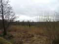
The hash is there ...
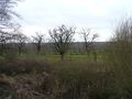
... or over there ...
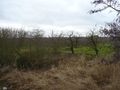
... or rather there .


Achievements
Hermann earned the Puppet Master Geohash achievement
|