Difference between revisions of "2011-01-30 46 8"
imported>TheOneRing (→The Plan) |
m (per Renaming Proposal) |
||
| (3 intermediate revisions by 2 users not shown) | |||
| Line 13: | Line 13: | ||
== The Expedition == | == The Expedition == | ||
=== TheOneRing === | === TheOneRing === | ||
| − | I decided to go to this geohash, because it was in a [[Virgin Graticule]]. I went by train to Alpnach via Lucerne, which took 1,5 hours. The geohash was a bit outside the village, so I made a little walk through it. The area, where I assumed the geohash, looked like private property and I looked every now and then, if I can see the owner to get permission (and the [[Ambassador achievement]]). First noone appeared, I walked to the geohash next to a farm house and I took the usual photos.<br/> | + | I decided to go to this geohash, because it was in a [[Virgin Graticule]]. I went by train to Alpnach (OW) via Lucerne (LU), which took only 1,5 hours. The geohash was a bit outside the village, so I made a little walk through it. The area, where I assumed the geohash, looked like private property and I looked every now and then, if I can see the owner to get permission (and the [[Ambassador achievement]]). First noone appeared, I walked to the geohash next to a farm house and I took the usual photos.<br/> |
| − | Suddenly the owner of the farm house came out and asked me, if I am taking photos. I confirmed his guess and asked, if I am allowed to do. I was prepared to explain, why I am there and what I was doing exactly, but he only said, that it is ok, the meadows, though private, are not restricted area. I thanked him, completed my galery of photos and made my way back to the village.<br/> | + | Suddenly the owner of the farm house came out and asked me, if I am taking photos. I confirmed his guess and asked, if I am allowed to do. I was prepared to explain, why I am there and what I was doing exactly, but he only said, that it is ok, the meadows, though private, are not restricted area. I thanked him, completed my galery of photos and made my way back to the village. Unfortunately the weather was not very nice, it was quite foggy all day.<br/> |
| − | Following a loudspeaker and my own curiosity I went directly into a sports event. But what of winter sport could this be? Finally I found out there took the '''Innerschweizer Crosslauf-Meisterschaft 2011''' place (Central Switzerland cross country running championships). I was quite stunned that this was taking place in January but I saw it with my own eyes.<br/> | + | Following a loudspeaker and my own curiosity I went directly into a sports event. But what kind of winter sport could this be? Finally I found out there took the '''Innerschweizer Crosslauf-Meisterschaft 2011''' place (Central Switzerland cross country running championships). I was quite stunned that this was taking place in January but I saw it with my own eyes.<br/> |
Afterwards I walked back to the train station and took the next train to Lucerne and from there to Berne. | Afterwards I walked back to the train station and took the next train to Lucerne and from there to Berne. | ||
| + | |||
| + | == Photos == | ||
| + | <gallery perrow="6"> | ||
| + | Image:20110130Train.jpg|The train I took to Alpnach | ||
| + | Image:20110130Seeblick.jpg|The house Seeblick (Lake view)... | ||
| + | Image:20110130KeinSeeblick.jpg|...but I can't see the lake. Anyone else? | ||
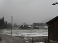
| + | Image:20110130Panorama.jpg|A panorama of the countryside (the geohash is right to the farm house) | ||
| + | Image:20110130Geohash1.jpg|The tripod marks the today's geohash | ||
| + | Image:20110130Geohash2.jpg|The geohash with farm house in the background | ||
| + | Image:20110130Bauernhaus.jpg|Farm house with Swiss flag | ||
| + | Image:20110130GPS.jpg|Proof that I reached the right coordinates... | ||
| + | Image:20110130Ticket.jpg|...on the right date | ||
| + | Image:20110130StupidGrin.jpg|Obligatory self shot | ||
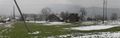
| + | Image:20110130Umgebung.jpg|The surrounding uphill (the flag in the center is of Obwalden) | ||
| + | Image:20110130Umgebung2.jpg|The surrounding downhill | ||
| + | </gallery> | ||
| + | |||
| + | == Achievements == | ||
| + | {{Graticule unlocked | latitude = 46 | longitude = 8 | date = 2011-01-30 | name = TheOneRing }} | ||
| + | {{land geohash | latitude = 46 | longitude = 8 | date = 2011-01-30 | name = TheOneRing }} | ||
| + | {{Public transport geohash | latitude = 46 | longitude = 8 | date = 2011-01-30 | name = TheOneRing}} | ||
| + | {{Ambassador geohash | latitude = 46 | longitude = 8 | date = 2011-01-30 | name = TheOneRing }} | ||
| + | {{Minesweeper geohash | graticule = Bern, Switzerland | ranknumber = 3 | e = true | ne = true | n = true | name = TheOneRing }} | ||
| + | {{Minesweeper geohash | graticule = Zürich, Switzerland | ranknumber = 3 | s = true | sw = true | w = true | name = TheOneRing }} | ||
| + | {{Minesweeper geohash | graticule = Basel, Switzerland | ranknumber = 3 | se = true | e = true | s = true | name = TheOneRing }} | ||
| + | |||
| + | [[Category:Expeditions]] | ||
| + | [[Category:Expeditions with photos]] | ||
| + | [[Category:Coordinates reached]] | ||
| + | {{location|CH|OW}} | ||
Latest revision as of 05:58, 20 March 2024
| Sun 30 Jan 2011 in 46,8: 46.9377187, 8.2592357 geohashing.info google osm bing/os kml crox |
Location
The geohash is near Alpnach (canton Obwalden).
Who Went
TheOneRing - by public transport.
The Expedition
TheOneRing
I decided to go to this geohash, because it was in a Virgin Graticule. I went by train to Alpnach (OW) via Lucerne (LU), which took only 1,5 hours. The geohash was a bit outside the village, so I made a little walk through it. The area, where I assumed the geohash, looked like private property and I looked every now and then, if I can see the owner to get permission (and the Ambassador achievement). First noone appeared, I walked to the geohash next to a farm house and I took the usual photos.
Suddenly the owner of the farm house came out and asked me, if I am taking photos. I confirmed his guess and asked, if I am allowed to do. I was prepared to explain, why I am there and what I was doing exactly, but he only said, that it is ok, the meadows, though private, are not restricted area. I thanked him, completed my galery of photos and made my way back to the village. Unfortunately the weather was not very nice, it was quite foggy all day.
Following a loudspeaker and my own curiosity I went directly into a sports event. But what kind of winter sport could this be? Finally I found out there took the Innerschweizer Crosslauf-Meisterschaft 2011 place (Central Switzerland cross country running championships). I was quite stunned that this was taking place in January but I saw it with my own eyes.
Afterwards I walked back to the train station and took the next train to Lucerne and from there to Berne.
Photos
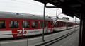
The train I took to Alpnach
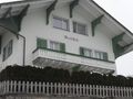
The house Seeblick (Lake view)...
...but I can't see the lake. Anyone else?
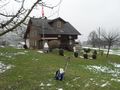
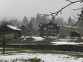
A panorama of the countryside (the geohash is right to the farm house)
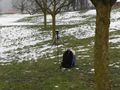
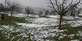
The tripod marks the today's geohash
The geohash with farm house in the background
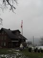
Farm house with Swiss flag
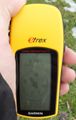
Proof that I reached the right coordinates...
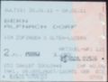
...on the right date
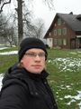
Obligatory self shot
The surrounding uphill (the flag in the center is of Obwalden)
The surrounding downhill


Achievements
TheOneRing earned the Graticule Unlocked Achievement
|
TheOneRing earned the Land geohash achievement
|
TheOneRing earned the Public transport geohash achievement
|
TheOneRing earned the Ambassador achievement
|
TheOneRing achieved level 3 of the Minesweeper Geohash achievement
|
TheOneRing achieved level 3 of the Minesweeper Geohash achievement
|
TheOneRing achieved level 3 of the Minesweeper Geohash achievement
|