Difference between revisions of "2011-02-16 52 5"
imported>Antior |
imported>FippeBot m (Location) |
||
| (7 intermediate revisions by 3 users not shown) | |||
| Line 1: | Line 1: | ||
| − | + | [[Image:2011-02-16_52_5_j.jpg|thumb|left]] | |
| − | |||
| − | |||
| − | |||
| − | |||
| − | |||
| − | |||
| − | |||
{{meetup graticule | {{meetup graticule | ||
| lat=52 | | lat=52 | ||
| Line 17: | Line 10: | ||
== Location == | == Location == | ||
Somewhere near Loosdrecht. Lots of water there, but the hash appears to be on dry land. | Somewhere near Loosdrecht. Lots of water there, but the hash appears to be on dry land. | ||
| + | |||
| + | |||
== Participants == | == Participants == | ||
| − | * [[User: | + | * [[User:CO2|CO2]] |
* [[User:Freeze_XJ|Freeze_XJ]] | * [[User:Freeze_XJ|Freeze_XJ]] | ||
== Plans == | == Plans == | ||
| − | Well, | + | Well, Mr. Freeze told CO2: "You're going hashing or I will '''destroy''' you." So that's the story. I guess I'm going hashing tomorrow. - [[User:CO2|CO2]] |
== Expedition == | == Expedition == | ||
| Line 29: | Line 24: | ||
After deciding to cycle there, we packed a map, a decent screenshot of the place (still no GPS), and went for it... The weather decided to help us, so we had a lot of sunshine, and only a few clouds, no wind to speak of, and about 10 degrees Celcius... Cycling to the hash was easy enough... | After deciding to cycle there, we packed a map, a decent screenshot of the place (still no GPS), and went for it... The weather decided to help us, so we had a lot of sunshine, and only a few clouds, no wind to speak of, and about 10 degrees Celcius... Cycling to the hash was easy enough... | ||
| − | You call this EASY? | + | |
| + | :''You call this EASY? There were upward slopes with more than 10 meters of height difference. I call that a mountain route! - [[User:CO2|CO2]]'' | ||
...and after a short break at the heath fields south of Hilversum, we arrived at the track leading us straight towards the hashpoint, slightly north of Oud Loosdrecht (translation might be something like Old Lostright, still thinking about a proper translation for something totally untranslatable). However, no cycling was allowed there, so we went on by foot, walking over an increasingly grassy path, past warnings of quicksand, nature and other dangers. | ...and after a short break at the heath fields south of Hilversum, we arrived at the track leading us straight towards the hashpoint, slightly north of Oud Loosdrecht (translation might be something like Old Lostright, still thinking about a proper translation for something totally untranslatable). However, no cycling was allowed there, so we went on by foot, walking over an increasingly grassy path, past warnings of quicksand, nature and other dangers. | ||
| + | |||
The hash itself was slightly off the path, in a particularly wet area, but we did manage to keep our feet dry. The way back involved nothing more than backtracking our way to our bikes, mounting them, and going south... Hmmm, or so we thought. The problem with relying on those nice pre-cooked bicycle sign routes is that once you miss 1 checkpoint, you can keep going on for miles before you realize something is wrong. We only found out that there was an issue when we entered Boomhoek (Treehook, if you translate it, and no, it does not walk). From there, our best option was simply going on, through several very small villages, until we reached a known road in Groenekan (Green Can, if you wish). The full trip took slightly over 4 hours, after which we both went home for a solid dinner. | The hash itself was slightly off the path, in a particularly wet area, but we did manage to keep our feet dry. The way back involved nothing more than backtracking our way to our bikes, mounting them, and going south... Hmmm, or so we thought. The problem with relying on those nice pre-cooked bicycle sign routes is that once you miss 1 checkpoint, you can keep going on for miles before you realize something is wrong. We only found out that there was an issue when we entered Boomhoek (Treehook, if you translate it, and no, it does not walk). From there, our best option was simply going on, through several very small villages, until we reached a known road in Groenekan (Green Can, if you wish). The full trip took slightly over 4 hours, after which we both went home for a solid dinner. | ||
== Photos == | == Photos == | ||
| − | + | ||
| − | |||
| − | |||
<gallery perrow="5"> | <gallery perrow="5"> | ||
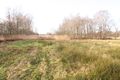
| − | Image:2011- | + | Image:2011-02-16_52_5_f.jpg | The Hilversum Heath, doggone important :P |
| − | Image: | + | Image:2011-02-16_52_5_a.jpg | Some more of that |
| − | Image:2011- | + | Image:2011-02-16_52_5_b.jpg | It's a kitty! We found on the way there. |
| − | Image:2011- | + | Image:2011-02-16_52_5_g.jpg | Local swan with companions |
| − | Image:2011- | + | Image:2011-02-16_52_5_c.jpg | This is what's left of the last people that tried... |
| + | Image:2011-02-16_52_5_h.jpg | Sign telling us we're in the right area | ||
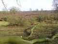
| + | Image:2011-02-16_52_5_d.jpg | Wet land. | ||
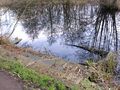
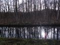
| + | Image:2011-02-16_52_5_i.jpg | The actual hashpoint... in the reeds | ||
| + | Image:2011-02-16_52_5_e.jpg | Standing on the hashpoint | ||
| + | Image:2011-02-16_52_5_j.jpg | A crocus attracting attention | ||
</gallery> | </gallery> | ||
| − | |||
[[Category:Expeditions]] | [[Category:Expeditions]] | ||
| Line 54: | Line 53: | ||
[[Category:Expedition without GPS]] | [[Category:Expedition without GPS]] | ||
[[Category:Coordinates reached]] | [[Category:Coordinates reached]] | ||
| + | {{location|NL|NH}} | ||
Latest revision as of 05:35, 9 August 2019

| Wed 16 Feb 2011 in 52,5: 52.2158268, 5.0904454 geohashing.info google osm bing/os kml crox |
Location
Somewhere near Loosdrecht. Lots of water there, but the hash appears to be on dry land.
Participants
Plans
Well, Mr. Freeze told CO2: "You're going hashing or I will destroy you." So that's the story. I guess I'm going hashing tomorrow. - CO2
Expedition
Report by Freeze_XJ (mostly).
After deciding to cycle there, we packed a map, a decent screenshot of the place (still no GPS), and went for it... The weather decided to help us, so we had a lot of sunshine, and only a few clouds, no wind to speak of, and about 10 degrees Celcius... Cycling to the hash was easy enough...
- You call this EASY? There were upward slopes with more than 10 meters of height difference. I call that a mountain route! - CO2
...and after a short break at the heath fields south of Hilversum, we arrived at the track leading us straight towards the hashpoint, slightly north of Oud Loosdrecht (translation might be something like Old Lostright, still thinking about a proper translation for something totally untranslatable). However, no cycling was allowed there, so we went on by foot, walking over an increasingly grassy path, past warnings of quicksand, nature and other dangers.
The hash itself was slightly off the path, in a particularly wet area, but we did manage to keep our feet dry. The way back involved nothing more than backtracking our way to our bikes, mounting them, and going south... Hmmm, or so we thought. The problem with relying on those nice pre-cooked bicycle sign routes is that once you miss 1 checkpoint, you can keep going on for miles before you realize something is wrong. We only found out that there was an issue when we entered Boomhoek (Treehook, if you translate it, and no, it does not walk). From there, our best option was simply going on, through several very small villages, until we reached a known road in Groenekan (Green Can, if you wish). The full trip took slightly over 4 hours, after which we both went home for a solid dinner.
Photos
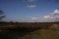
The Hilversum Heath, doggone important :P
Some more of that
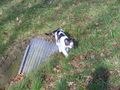
It's a kitty! We found on the way there.
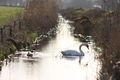
Local swan with companions
This is what's left of the last people that tried...
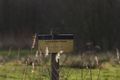
Sign telling us we're in the right area
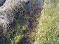
Wet land.
The actual hashpoint... in the reeds
Standing on the hashpoint
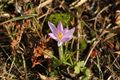
A crocus attracting attention


