Difference between revisions of "2011-02-21 52 5"
From Geohashing
imported>Antior |
imported>FippeBot m (Location) |
||
| (7 intermediate revisions by 2 users not shown) | |||
| Line 1: | Line 1: | ||
| − | + | [[Image:2011-02-21_52_5e.jpg|thumb|left]] | |
| − | |||
| − | |||
| − | |||
| − | |||
| − | |||
| − | |||
| − | |||
{{meetup graticule | {{meetup graticule | ||
| lat=52 | | lat=52 | ||
| Line 20: | Line 13: | ||
== Participants == | == Participants == | ||
| − | A friend of [[User: | + | A friend of [[User:CO2|CO2's]]. |
== Plans == | == Plans == | ||
| Line 26: | Line 19: | ||
== Expedition == | == Expedition == | ||
| − | + | ''(This report was written by CO2's friend)'' | |
| + | |||
| + | The hashpoint was near a bus stop I always pass, so easy enough to get to. I got off the bus at said bus stop and walked to the hash in the freezing cold. The hashpoint was two blocks away, right on a parking spot, with a car parked right on it. I took some pictures there and then returned to the warm bus and continued my way to class. | ||
== Photos == | == Photos == | ||
| − | |||
| − | |||
| − | |||
<gallery perrow="5"> | <gallery perrow="5"> | ||
| + | Image:2011-02-21_52_5a.jpg | Bus stop | ||
| + | Image:2011-02-21_52_5b.jpg | Hashpoint | ||
| + | Image:2011-02-21_52_5c.jpg | Street with the hashpoint | ||
| + | Image:2011-02-21_52_5d.jpg | Canal next to the street | ||
| + | Image:2011-02-21_52_5e.jpg | Typical bus in Utrecht | ||
</gallery> | </gallery> | ||
== Achievements == | == Achievements == | ||
{{#vardefine:ribbonwidth|800px}} | {{#vardefine:ribbonwidth|800px}} | ||
| − | |||
| + | {{land geohash | ||
| + | | latitude = 52 | ||
| + | | longitude = 5 | ||
| + | | date = 2011-02-21 | ||
| + | }} | ||
| − | + | {{No_batteries_geohash | |
| − | + | | latitude = 52 | |
| − | + | | longitude = 5 | |
| − | + | | date = 2011-02-21 | |
| − | + | }} | |
| − | |||
| − | |||
| + | Possibly also a Freezing Geohash, but this can't be proven. | ||
| − | |||
[[Category:Expeditions]] | [[Category:Expeditions]] | ||
| − | |||
[[Category:Expeditions with photos]] | [[Category:Expeditions with photos]] | ||
| − | |||
[[Category:Expedition without GPS]] | [[Category:Expedition without GPS]] | ||
| − | |||
| − | |||
| − | |||
[[Category:Coordinates reached]] | [[Category:Coordinates reached]] | ||
| − | + | {{location|NL|UT}} | |
| − | |||
| − | |||
| − | |||
| − | |||
| − | |||
| − | |||
| − | |||
| − | |||
| − | |||
Latest revision as of 05:37, 9 August 2019

| Mon 21 Feb 2011 in 52,5: 52.0777414, 5.1213441 geohashing.info google osm bing/os kml crox |
Location
In the center of Utrecht.
Participants
A friend of CO2's.
Plans
It's close to a bus stop. Just visit it and take a few pictures.
Expedition
(This report was written by CO2's friend)
The hashpoint was near a bus stop I always pass, so easy enough to get to. I got off the bus at said bus stop and walked to the hash in the freezing cold. The hashpoint was two blocks away, right on a parking spot, with a car parked right on it. I took some pictures there and then returned to the warm bus and continued my way to class.
Photos
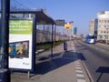
Bus stop
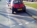
Hashpoint
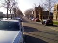
Street with the hashpoint
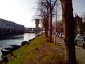
Canal next to the street
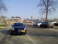
Typical bus in Utrecht


Achievements
This user earned the Land geohash achievement
|
This user earned the No Batteries Geohash Achievement
|
Possibly also a Freezing Geohash, but this can't be proven.