2011-02-23 43 4
From Geohashing
Revision as of 19:40, 23 February 2011 by imported>Sourcerer (Created page with "== Location == In a reed bed 844 metres south east of the Draillasse de Saint-Gilles access road in the Camargue Natural Park. {{meetup graticule | lat=43 | lon=4 ...")
Contents
Location
In a reed bed 844 metres south east of the Draillasse de Saint-Gilles access road in the Camargue Natural Park.
| Wed 23 Feb 2011 in Nîmes: 43.6544104, 4.5305760 geohashing.info google osm bing/os kml crox |
Participants
The Failed Expedition
Sourcerer was walking from Générac to Arles and the pre-planned route passed near the geohash. It was possible to get to within 844 metres but gates, dykes and reed beds made access impossible. The first reason was lack of public access. Had access been possible, the reed bed might still have been inaccessible. The reed bed may have been an abandoned rice paddy, allowed to revert for nature conservation reasons.
Sourcerer earned the No trespassing consolation prize
|
Photo Gallery
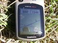
GPS Evidence
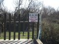
Private Property
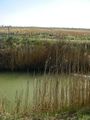
Dyke and Reeds Prevent Access
Seriously No Access!
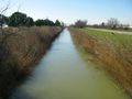
In Lincolnshire, they use a long pole to vault a ditch like this
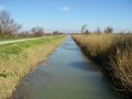
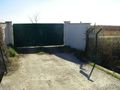
No Access the Other Way Either


Other Geohashing Expeditions and Plans on This Day
Expeditions and Plans
| 2011-02-23 | ||
|---|---|---|
| Midland, Texas | Phineas | On Hogan Rd., between Waddell and North Loop 250. |
| Roswell, Georgia | NWoodruff | Off to the side of the road in Suwanee. |
| Fond du Lac, Wisconsin | Someone went | Somewhere |
| Nîmes, France | Sourcerer | In a reed bed 844 metres south east of the Draillasse de Saint-Gilles acces... |
| Vancouver, British Columbia | User:thepiguy | Secret tennis court FTW! |