Difference between revisions of "2011-02-26 39 -0"
imported>MykaDragonBlue (→Participants: <--) |
imported>MykaDragonBlue (→Achievements: cherry) |
||
| Line 63: | Line 63: | ||
<!-- Add any achievement ribbons you earned below, or remove this section --> | <!-- Add any achievement ribbons you earned below, or remove this section --> | ||
| + | {{Virgin graticule | ||
| + | | latitude = 39 | ||
| + | | longitude = -0 | ||
| + | | date = 2011-02-26 | ||
| + | | name = [[User:mykaDragonBlue|myka]] and [[User:MykaDragonBlue/Hashscot|possibly Fergus]] | ||
| + | | image = 2011-02-26 39 -0 mdb 003.jpg | ||
| + | }} | ||
| − | |||
| − | |||
| − | |||
| − | |||
| − | |||
| − | |||
| − | |||
| − | |||
| − | |||
[[Category:Expeditions]] | [[Category:Expeditions]] | ||
| − | |||
[[Category:Expeditions with photos]] | [[Category:Expeditions with photos]] | ||
| − | |||
| − | |||
| − | |||
| − | |||
| − | |||
[[Category:Coordinates reached]] | [[Category:Coordinates reached]] | ||
| − | |||
| − | |||
| − | |||
| − | |||
| − | |||
| − | |||
| − | |||
| − | |||
| − | |||
| − | |||
Revision as of 21:41, 2 March 2011
| Sat 26 Feb 2011 in 39,-0: 39.5847362, -0.5654490 geohashing.info google osm bing/os kml crox |
Location
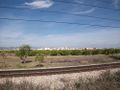
hash found outside Valencia, Spain, in one of a series of small plots used to grow various crops.
Participants
myka and possibly Fergus
Plans
Expedition
by chance i was stopped outside valencia and decided to check the coordinates for the day.
lo and behold (once i managed to get them) the hash turned out to be only 20km away, in roughly the direction i was going anyway. i entered the point in my GPS and let it direct me to within a few hundred meters. knowing the OSM map i had would be unlikely to include all the little service roads, i knew i'd have to override it from there.
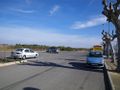
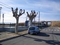
i did a quick drive by first, but decided not to take the car in because someone was working in the next field, and this van does stand out as being nut local. instead, i parked at the metro station just a few hundred meters away (the Spanish seem to have something against leaving space to park on the roadside).
crossing the track a couple of times (carefully, in order to use roads and paths instead or wandering through the fields) i made my way to the exact spot, right under a pile of dead branches, took some photos, then walked back to the van.
now onwards and northwards
--myka
- photos might take quite a while
Tracklog
Photos
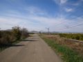
the road
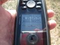
the proofs
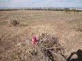
the hash
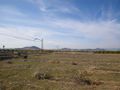
the view
the town
the van
the metro


