Difference between revisions of "2011-02-26 45 -122"
imported>Michael5000 (→Achievements) |
imported>Michael5000 (→Photos) |
||
| Line 42: | Line 42: | ||
--> | --> | ||
<gallery perrow="5"> | <gallery perrow="5"> | ||
| + | File:2010-02-26_45_-122_Me.JPG|I don't mind telling you it was a cold day for a bike ride. | ||
| + | File:2010-02-26_45_-122_Trail_Bear.JPG|The Columbia River Bike Trail is quite awesome. | ||
| + | File:2010-02-26_45_-122_Plane.JPG|The hashpoint is right off the end of the north runway at PDX. I was grazed by Horizon's plane with the livery of my ''alma mater''! | ||
| + | File:2010-02-26 45 -122 Bear Scrawl.JPG|We left a message for other cold-weather adventurers. | ||
</gallery> | </gallery> | ||
Revision as of 21:55, 26 February 2011
| Sat 26 Feb 2011 in 45,-122: 45.5847362, -122.5654490 geohashing.info google osm bing/os kml crox |
Location
On the Columbia River Bike Path between Marine Drive and the Columbia.
Participants
Plans
Jim has a get-together in Salem, so was going to leave shortly to try to go to the hashpoint before heading South.
Michael5000 planned, as a new year's resolution with UnwiseOwl, to go geohashing on Feb. 26 no matter what. It's just good luck that today's hashpoint turned out to be something of a creampuff.
Expedition
Michael5000 dressed pretty warmly for a sub-freezing bicycle ride, but still lost track of his toes four miles into the nineteen-mile jaunt. Google Maps clearly shows the hashpoint on the trail; by my GPS the point was about a foot and a half north of the trail. I left a message for passers-by, and no doubt somebody at the other end of a CCT camera noticed the dude with a black balaclava making chalk marks and photographing airport operations. Then I rode home.
Tracklog
Photos
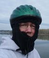
I don't mind telling you it was a cold day for a bike ride.
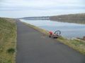
The Columbia River Bike Trail is quite awesome.
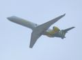
The hashpoint is right off the end of the north runway at PDX. I was grazed by Horizon's plane with the livery of my alma mater!
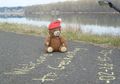
We left a message for other cold-weather adventurers.


Achievements
