Difference between revisions of "2011-03-02 44 -90"
imported>Atrum |
m (per Renaming Proposal) |
||
| (22 intermediate revisions by 3 users not shown) | |||
| Line 14: | Line 14: | ||
}} | }} | ||
| − | + | ||
__NOTOC__ | __NOTOC__ | ||
== Location == | == Location == | ||
| Line 20: | Line 20: | ||
== Participants == | == Participants == | ||
| − | + | ||
*[[user:Atrum|Atrum]] | *[[user:Atrum|Atrum]] | ||
*[[user:Dratheus|Dratheus]] | *[[user:Dratheus|Dratheus]] | ||
== Plans == | == Plans == | ||
| − | Our plans were to drive to a spot near the hashpoint. | + | Our plans were to drive to a spot near the hashpoint. |
| + | |||
| + | We then planned on calling up the land owner and requesting permission to access the field. We also | ||
| + | brought along some snowshoes in case we were able to walk to the hash on the other end of the field. | ||
| + | |||
| + | If we couldn't contact the owner, we were going to decide there if we still wanted to go. If we were | ||
| + | denied permission, we were going to just get as close as we could while on public land. | ||
== Expedition == | == Expedition == | ||
| − | |||
| − | |||
| − | + | This was both Dratheus' and my (Atrum's) first expedition. | |
| − | + | ||
| + | We first disembarked in the car from Drath's home to the north of Spencer. We traveled to Spencer | ||
| + | and started to head east on highway C. We followed C until it reached a town called Rozelleville | ||
| + | where we started to head south on highway M. | ||
| + | |||
| + | It was on highway M that we saw about 30 whitetail | ||
| + | deer eating in a field just before dark, with some turkeys in another field near by. Eventually, | ||
| + | we turned west on highway H and came to a road called Shady Road. We missed the turn and had to | ||
| + | turn north on some other road, working our way back to the west to hook up with Shady Road. | ||
| + | We came to an intersection right near the field where the hash was located at. | ||
| + | |||
| + | After a failed | ||
| + | attempt to contact the owner, we decided we didn't want to come all this way for nothing. | ||
| + | Getting on our snowshoes, we walked to the west around the cut down corn and got far enough | ||
| + | that we were able to cut back to the south to where we believed the hash to be. | ||
| + | |||
| + | On Google Earth, you can see the shadow of a large pine tree and we orientated ourselves with what we | ||
| + | believed to be the same tree. There was also a small food plot (standing corn) in a small | ||
| + | indent on the west side of the field and we were able to see this as well and were able to get | ||
| + | our bearings. After deciding we were at the right spot, we took our pictures and headed back | ||
| + | over the same tracks we already made. | ||
| + | |||
| + | When we got back to the car, Drath discovered he had been | ||
| + | violently attacked by raptors (his snowshoes rubbed away at his ankles) and we worked our way to | ||
| + | Marshfield after snagging a picture of some yaks at a farm near by. We stopped at McDonald's where | ||
| + | he got food and I got a Shamrock shake. | ||
| + | |||
| + | Our evening ended perfectly as after we went through | ||
| + | Spencer on the return trip home, "Africa" by Toto was played on the radio, one of the best songs | ||
| + | ever created. And that was our first expedition. | ||
| + | |||
== Photos == | == Photos == | ||
<gallery perrow="5"> | <gallery perrow="5"> | ||
Image:CloseUp Google.jpg | A closer image of the hash via Google Maps/Google Earth. | Image:CloseUp Google.jpg | A closer image of the hash via Google Maps/Google Earth. | ||
| + | Image:Regional Google.jpg | The hash from a little farther out. | ||
| + | Image:Route March 2.jpg | The route traveled to the hash. County highways written in. | ||
| + | Image:DSCN0140.JPG | The field we traversed, facing east. | ||
| + | Image:Drath car.JPG | Drath's car and the scenery and field from the hash, facing northwest. | ||
| + | Image:Drath Fell.JPG | Dratheus when he fell over while attempting to walk backwards in snowshoes. | ||
| + | Image:Atrum Pine.JPG | Me, Atrum, at the hash. The pine in the background is the one from Google Earth. | ||
| + | Image:WI Forest.JPG | The forest to the east. The big pine is the one we used for navigation. | ||
| + | Image:March 2 sunset.JPG | Sunset from the hash; farm with the yaks. | ||
| + | Image:Foodplot.JPG | Foodplot to the northeast. This is also the indent of the woods on Google Earth. | ||
| + | Image:WI Raptor Attack.JPG | Raptors! | ||
| + | Image:MandH.JPG | Proof that we were at least at the intersection of M and H. | ||
| + | Image:WI yak.JPG | Yaks! | ||
| + | Image:Deer.JPG | 25+ deer in a field by highway M. | ||
| + | Image:Brrrrrr.JPG | 16 degrees Fahrenheit. Achievement please? | ||
</gallery> | </gallery> | ||
== Achievements == | == Achievements == | ||
{{#vardefine:ribbonwidth|800px}} | {{#vardefine:ribbonwidth|800px}} | ||
| − | + | ||
| + | {{land geohash | ||
| + | |||
| + | | latitude = 44 | ||
| + | | longitude = -90 | ||
| + | | date = 2011-03-02 | ||
| + | | name = Atrum and Dratheus | ||
| + | | image = Atrum Pine.JPG | ||
| + | }} | ||
| + | {{Frozen Geohash | ||
| + | |||
| + | | latitude = 44 | ||
| + | | longitude = -90 | ||
| + | | date = 2011-03-02 | ||
| + | | temperature = 16°F | ||
| + | | name = Atrum and Dratheus | ||
| + | | image = Brrrrrr.JPG | ||
| + | }} | ||
| + | {{No_batteries_geohash | ||
| + | |||
| + | | latitude = 44 | ||
| + | | longitude = -90 | ||
| + | | date = 2011-03-02 | ||
| + | | name = Atrum and Dratheus | ||
| + | | image = CloseUp Google.jpg | ||
| + | }} | ||
| + | {{Velociraptor geohash | ||
| + | |||
| + | | latitude = 44 | ||
| + | | longitude = -90 | ||
| + | | date = 2011-03-02 | ||
| + | | name = Dratheus | ||
| + | | image = WI Raptor Attack.JPG | ||
| + | }} | ||
| + | {{Graticule unlocked | ||
| + | |||
| + | | latitude = 44 | ||
| + | | longitude = -90 | ||
| + | | date = 2011-03-02 | ||
| + | | name = Atrum and Dratheus | ||
| + | }} | ||
| − | |||
| − | |||
| − | |||
| − | |||
| − | |||
| − | |||
| − | |||
| − | |||
[[Category:Expeditions]] | [[Category:Expeditions]] | ||
| − | + | ||
[[Category:Expeditions with photos]] | [[Category:Expeditions with photos]] | ||
| − | + | ||
[[Category:Expedition without GPS]] | [[Category:Expedition without GPS]] | ||
| − | + | ||
| − | |||
| − | |||
[[Category:Coordinates reached]] | [[Category:Coordinates reached]] | ||
| − | + | {{location|US|WI|WO}} | |
| − | |||
| − | |||
| − | |||
| − | |||
| − | |||
| − | |||
| − | |||
| − | |||
| − | |||
Latest revision as of 05:56, 20 March 2024
| Wed 2 Mar 2011 in 44,-90: 44.6620520, -90.0380045 geohashing.info google osm bing/os kml crox |
Location
The hash was located near the town of Hewitt and Auburndale in the Marshfield graticule. It was located in a field near county highway H.
Participants
Plans
Our plans were to drive to a spot near the hashpoint.
We then planned on calling up the land owner and requesting permission to access the field. We also brought along some snowshoes in case we were able to walk to the hash on the other end of the field.
If we couldn't contact the owner, we were going to decide there if we still wanted to go. If we were denied permission, we were going to just get as close as we could while on public land.
Expedition
This was both Dratheus' and my (Atrum's) first expedition.
We first disembarked in the car from Drath's home to the north of Spencer. We traveled to Spencer and started to head east on highway C. We followed C until it reached a town called Rozelleville where we started to head south on highway M.
It was on highway M that we saw about 30 whitetail deer eating in a field just before dark, with some turkeys in another field near by. Eventually, we turned west on highway H and came to a road called Shady Road. We missed the turn and had to turn north on some other road, working our way back to the west to hook up with Shady Road. We came to an intersection right near the field where the hash was located at.
After a failed attempt to contact the owner, we decided we didn't want to come all this way for nothing. Getting on our snowshoes, we walked to the west around the cut down corn and got far enough that we were able to cut back to the south to where we believed the hash to be.
On Google Earth, you can see the shadow of a large pine tree and we orientated ourselves with what we believed to be the same tree. There was also a small food plot (standing corn) in a small indent on the west side of the field and we were able to see this as well and were able to get our bearings. After deciding we were at the right spot, we took our pictures and headed back over the same tracks we already made.
When we got back to the car, Drath discovered he had been violently attacked by raptors (his snowshoes rubbed away at his ankles) and we worked our way to Marshfield after snagging a picture of some yaks at a farm near by. We stopped at McDonald's where he got food and I got a Shamrock shake.
Our evening ended perfectly as after we went through Spencer on the return trip home, "Africa" by Toto was played on the radio, one of the best songs ever created. And that was our first expedition.
Photos
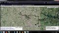
A closer image of the hash via Google Maps/Google Earth.
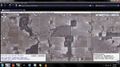
The hash from a little farther out.
The route traveled to the hash. County highways written in.
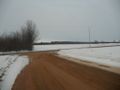
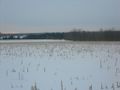
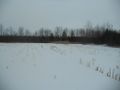
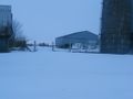
The field we traversed, facing east.
Drath's car and the scenery and field from the hash, facing northwest.
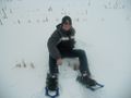
Dratheus when he fell over while attempting to walk backwards in snowshoes.
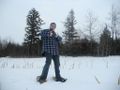
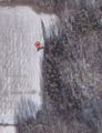
Me, Atrum, at the hash. The pine in the background is the one from Google Earth.
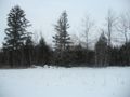
The forest to the east. The big pine is the one we used for navigation.
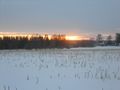
Sunset from the hash; farm with the yaks.
Foodplot to the northeast. This is also the indent of the woods on Google Earth.
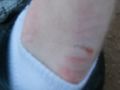
Raptors!
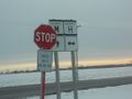
Proof that we were at least at the intersection of M and H.
Yaks!
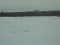
25+ deer in a field by highway M.
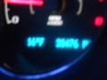
16 degrees Fahrenheit. Achievement please?


Achievements
Atrum and Dratheus earned the Land geohash achievement
|

Atrum and Dratheus earned the No Batteries Geohash Achievement
|
Dratheus earned the Velociraptor Geohash Achievement
|
Atrum and Dratheus earned the Graticule Unlocked Achievement
|