Difference between revisions of "2011-03-06 50 8"
imported>Mampfred (Created page with "{{subst:Expedition |lat = 50 |lon = 5 |date = 2011-03-06 }}") |
imported>FippeBot m (Location) |
||
| (4 intermediate revisions by one other user not shown) | |||
| Line 1: | Line 1: | ||
| − | + | {{advert|image=2011-03-06_50_8_marker.jpg}} | |
| − | |||
| − | |||
| − | |||
| − | |||
| − | |||
| − | |||
| − | |||
| − | |||
| − | |||
{{meetup graticule | {{meetup graticule | ||
| lat=50 | | lat=50 | ||
| − | | lon= | + | | lon=8 |
| date=2011-03-06 | | date=2011-03-06 | ||
}} | }} | ||
| − | |||
__NOTOC__ | __NOTOC__ | ||
== Location == | == Location == | ||
| − | + | Somewhere in a strip of wood near Oestrich-Winkel. | |
== Participants == | == Participants == | ||
| − | + | *[[User:Mampfred|Mampfred]] | |
| + | *[[User:LadyBB|LadyBB]] | ||
| + | |||
| + | == Expedition == | ||
| + | We started off at 2:30pm and took the A66/B42 to Oestrich-Winkel. Google actually showed a road leading most of the way to the hash but unfortunately it wasn't open to the public (residents only). So considering the brilliant weather that day we parked at the "Lohmühle" about 2 km from the hash and started walking. | ||
| − | + | We came across a very nice view point looking back across Oestrich-Winkel, took a couple of photos and noted that we were following the "Flötenweg". From there we seem to have crossed an airstrip for model airplanes (see sign below) before finding a little horse riding center hidden in the woods with two dogs that went mental from as far as a couple of hundred meters away. | |
| − | |||
| − | + | Moving on (strangely going up all the time) we got closer and LadyBB took over the GPS. At which point Mampfred did get ... let's call it impatient, as these things aren't as intuitive as you might think. The GPS, not LadyBB. Well, both, actually. Anyway, we eventually found the hash, built an XKCD sign and planted the marker a couple of meters into the woods. | |
| − | + | ||
| + | On the way back we passed a strange ruin which apparently is video surveiled to discourage thefts ... although it doesn't exactly look like there's something to steal there. We didn't even try so we'll never find out if there's a) something to steal or b) indeed a surveilance system ;) | ||
| + | |||
| + | We visited some old friends of LadyBB on the way back which is why the GPS track stops quite suddenly because we didn't want to reveal their location. Thanks for the coffee :) | ||
| + | |||
| + | In total we walked about 6km up and down a hill with a 210m altitude difference, look at the last bit of the track log where the speed/altitude graph looks like the very hill itself. I might be wrong here but I do get the feeling sometimes that for some reason hashes tend to be on top of steep hills in our area. [[Bill Gates Achievement|Bill]], you doing that on purpose? | ||
== Tracklog == | == Tracklog == | ||
| − | + | See [http://www.everytrail.com/view_trip.php?trip_id=991750 here]. | |
== Photos == | == Photos == | ||
| − | |||
| − | |||
| − | |||
<gallery perrow="5"> | <gallery perrow="5"> | ||
| + | Image:2011-03-06_50_8_cottage_1.jpg | Where we parked, which is opposite the ... | ||
| + | Image:2011-03-06_50_8_lohmuehle.jpg | ... Lohmühle. | ||
| + | Image:2011-03-06_50_8_map_floetenweg.jpg | Walking along the "Flötenweg" | ||
| + | </gallery> | ||
| + | <gallery perrow="1" widths=600px> | ||
| + | Image:2011-03-06_50_8_panorama_1.jpg | Very nice panorama from the view point | ||
| + | </gallery> | ||
| + | <gallery perrow="5"> | ||
| + | Image:2011-03-06_50_8_sign.jpg | Passing a model pane airstrip. "Do not stop! Move along quickly!" | ||
| + | Image:2011-03-06_50_8_waldhof.jpg | A riding center along the way called "Waldhof" ... | ||
| + | Image:2011-03-06_50_8_wolf.jpg | ... with some dogs (only one in the picture) going mental in front of it. | ||
| + | Image:2011-03-06_50_8_here.jpg | LadyBB looking confused. Here? | ||
| + | Image:2011-03-06_50_8_coordinates.jpg | Coordinates ... | ||
| + | Image:2011-03-06_50_8_reached.jpg | ... reached. | ||
| + | Image:2011-03-06_50_8_woods.jpg | Hash-rays. | ||
| + | Image:2011-03-06_50_8_woman_and_grins.jpg | Female: grin. Male: annoyed at female working the GPS ;) | ||
| + | Image:2011-03-06_50_8_marker.jpg | Our active geohasher marker ... | ||
| + | Image:2011-03-06_50_8_xkcd.jpg | ... and the XKCD sign ... | ||
| + | Image:2011-03-06_50_8_xkcd_sign.jpg | ... united. | ||
| + | Image:2011-03-06_50_8_panorama_2.jpg | Another shot of the panorama. | ||
| + | Image:2011-03-06_50_8_castle_2.jpg | Strange ruin on the way back. | ||
| + | Image:2011-03-06_50_8_sunset.jpg | This took longer than expected, the sun is setting soon. | ||
</gallery> | </gallery> | ||
== Achievements == | == Achievements == | ||
{{#vardefine:ribbonwidth|800px}} | {{#vardefine:ribbonwidth|800px}} | ||
| − | + | {{Land geohash | |
| + | | latitude = 50 | ||
| + | | longitude = 8 | ||
| + | | date = 2011-03-06 | ||
| + | | name = [[User:Mampfred|Mampfred]] and [[User:LadyBB|LadyBB]] | ||
| + | }} | ||
| + | {{Consecutive_geohash | ||
| + | | latitude = 50 | ||
| + | | longitude = 8 | ||
| + | | count = 2 | ||
| + | | date = 2011-03-05 | ||
| + | | name = Mampfred and LadyBB | ||
| + | }} | ||
| − | |||
| − | |||
| − | |||
| − | |||
| − | |||
| − | |||
| − | |||
| − | |||
| − | |||
| − | |||
| − | |||
[[Category:Expeditions]] | [[Category:Expeditions]] | ||
| − | |||
[[Category:Expeditions with photos]] | [[Category:Expeditions with photos]] | ||
| − | |||
| − | |||
| − | |||
| − | |||
| − | |||
[[Category:Coordinates reached]] | [[Category:Coordinates reached]] | ||
| − | + | {{location|DE|HE|SWA}} | |
| − | |||
| − | |||
| − | |||
| − | |||
| − | |||
| − | |||
| − | |||
| − | |||
| − | |||
Latest revision as of 05:45, 9 August 2019
| Have you seen our geohashing marker? We'd love to hear from you! Click here to say "hi" and tell us what you've seen!
Curious about what geohashing is? Read more! |  |
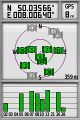
| Sun 6 Mar 2011 in 50,8: 50.0356622, 8.0063962 geohashing.info google osm bing/os kml crox |
Location
Somewhere in a strip of wood near Oestrich-Winkel.
Participants
Expedition
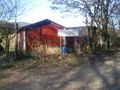
We started off at 2:30pm and took the A66/B42 to Oestrich-Winkel. Google actually showed a road leading most of the way to the hash but unfortunately it wasn't open to the public (residents only). So considering the brilliant weather that day we parked at the "Lohmühle" about 2 km from the hash and started walking.
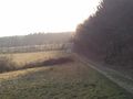
We came across a very nice view point looking back across Oestrich-Winkel, took a couple of photos and noted that we were following the "Flötenweg". From there we seem to have crossed an airstrip for model airplanes (see sign below) before finding a little horse riding center hidden in the woods with two dogs that went mental from as far as a couple of hundred meters away.
Moving on (strangely going up all the time) we got closer and LadyBB took over the GPS. At which point Mampfred did get ... let's call it impatient, as these things aren't as intuitive as you might think. The GPS, not LadyBB. Well, both, actually. Anyway, we eventually found the hash, built an XKCD sign and planted the marker a couple of meters into the woods.
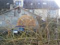
On the way back we passed a strange ruin which apparently is video surveiled to discourage thefts ... although it doesn't exactly look like there's something to steal there. We didn't even try so we'll never find out if there's a) something to steal or b) indeed a surveilance system ;)
We visited some old friends of LadyBB on the way back which is why the GPS track stops quite suddenly because we didn't want to reveal their location. Thanks for the coffee :)
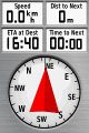
In total we walked about 6km up and down a hill with a 210m altitude difference, look at the last bit of the track log where the speed/altitude graph looks like the very hill itself. I might be wrong here but I do get the feeling sometimes that for some reason hashes tend to be on top of steep hills in our area. Bill, you doing that on purpose?
Tracklog
See here.
Photos
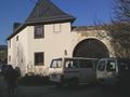
Where we parked, which is opposite the ...
... Lohmühle.
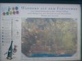
Walking along the "Flötenweg"


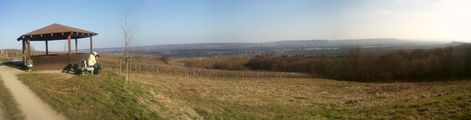
Very nice panorama from the view point

Passing a model pane airstrip. "Do not stop! Move along quickly!"
A riding center along the way called "Waldhof" ...
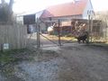
... with some dogs (only one in the picture) going mental in front of it.
LadyBB looking confused. Here?
Coordinates ...
... reached.
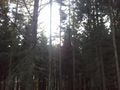
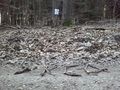
Hash-rays.
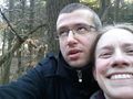
Female: grin. Male: annoyed at female working the GPS ;)
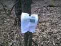
Our active geohasher marker ...
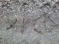
... and the XKCD sign ...
... united.
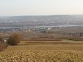
Another shot of the panorama.
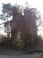
Strange ruin on the way back.
This took longer than expected, the sun is setting soon.


Achievements
Mampfred and LadyBB earned the Land geohash achievement
|
Mampfred and LadyBB earned the Consecutive geohash achievement
|