Difference between revisions of "2011-03-09 50 8"
imported>Mampfred (Created page with "{{subst:Expedition |lat = 50 |lon = 8 |date = 2011-03-09 }}") |
imported>FippeBot m (Location) |
||
| (5 intermediate revisions by 2 users not shown) | |||
| Line 1: | Line 1: | ||
| − | |||
| − | |||
| − | |||
| − | |||
| − | |||
| − | |||
| − | |||
| − | |||
| − | |||
| − | |||
{{meetup graticule | {{meetup graticule | ||
| lat=50 | | lat=50 | ||
| Line 15: | Line 5: | ||
}} | }} | ||
| − | |||
__NOTOC__ | __NOTOC__ | ||
== Location == | == Location == | ||
| − | + | Too close to miss this one, a little outside Wiesbaden. | |
== Participants == | == Participants == | ||
| − | + | *[[User:LadyBB|LadyBB]] | |
| + | |||
| + | == Expedition == | ||
| + | Because the hash is located between Wiesbaden-Erbenheim and Wiesbaden-Igstadt in a field and just a few kilometers from my working place, I decided to do the hash instead a proper lunch break in the early afternoon. | ||
| − | + | I drove 5 km to the community centre Erbenheim and walked around 2 km along a very good frequented and bituminised hiking and cycle track. On my way I met several inline skaters, strollers, walkers, one lady with a baby buggy, one rider with her horse and nearly on the end of my walk back to Erbenheim a youth group with their chaperon who explained them different trees. | |
| − | |||
| − | + | But when I left the official track to head for the hash coordinates I was just on my own. I passed two big trees (the area around them was very swampy) and landed at last on dry field. I took a few pictures of myself, the hash point and the hash area and went back to my car. | |
| − | |||
== Tracklog == | == Tracklog == | ||
| − | + | TODO | |
== Photos == | == Photos == | ||
| − | |||
| − | |||
| − | |||
<gallery perrow="5"> | <gallery perrow="5"> | ||
| + | Image:2011-03-09_50_8_car.jpg | The hash car at the "Bürgerhaus Erbenheim". | ||
| + | Image:2011-03-09_50_8_coordinates.jpg | Coordinates reached! | ||
| + | Image:2011-03-09_50_8_grin.jpg | The grin picture and in the background ... | ||
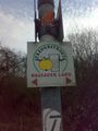
| + | Image:2011-03-09_50_8_sign_3.jpg | ... a sign to for a farm shop. | ||
| + | Image:2011-03-09_50_8_bush.jpg | The swampy trees from the hash point, | ||
| + | Image:2011-03-09_50_8_field.jpg | view to Igstadt ... | ||
| + | Image:2011-03-09_50_8_field_2.jpg | ... and back to Erbenheim. | ||
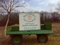
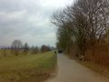
| + | Image:2011-03-09_50_8_sign.jpg | The tack is a popular cycle route ... | ||
| + | Image:2011-03-09_50_8_sign_2.jpg | ... as well as walking trail. | ||
| + | Image:2011-03-09_50_8_track.jpg | The youth group aT the end of the expedition. | ||
</gallery> | </gallery> | ||
== Achievements == | == Achievements == | ||
{{#vardefine:ribbonwidth|800px}} | {{#vardefine:ribbonwidth|800px}} | ||
| − | + | {{Land geohash | |
| − | + | | latitude = 50 | |
| − | + | | longitude = 8 | |
| − | + | | date = 2011-03-09 | |
| − | + | | name = [[User:LadyBB|LadyBB]] | |
| − | [[ | + | }} |
| − | |||
| − | |||
| − | |||
| − | |||
| − | |||
| − | |||
[[Category:Expeditions]] | [[Category:Expeditions]] | ||
| − | |||
[[Category:Expeditions with photos]] | [[Category:Expeditions with photos]] | ||
| − | |||
| − | |||
| − | |||
| − | |||
| − | |||
[[Category:Coordinates reached]] | [[Category:Coordinates reached]] | ||
| − | + | {{location|DE|HE|WI}} | |
| − | |||
| − | |||
| − | |||
| − | |||
| − | |||
| − | |||
| − | |||
| − | |||
| − | |||
Latest revision as of 05:46, 9 August 2019
| Wed 9 Mar 2011 in 50,8: 50.0732677, 8.3145703 geohashing.info google osm bing/os kml crox |
Location
Too close to miss this one, a little outside Wiesbaden.
Participants
Expedition
Because the hash is located between Wiesbaden-Erbenheim and Wiesbaden-Igstadt in a field and just a few kilometers from my working place, I decided to do the hash instead a proper lunch break in the early afternoon.
I drove 5 km to the community centre Erbenheim and walked around 2 km along a very good frequented and bituminised hiking and cycle track. On my way I met several inline skaters, strollers, walkers, one lady with a baby buggy, one rider with her horse and nearly on the end of my walk back to Erbenheim a youth group with their chaperon who explained them different trees.
But when I left the official track to head for the hash coordinates I was just on my own. I passed two big trees (the area around them was very swampy) and landed at last on dry field. I took a few pictures of myself, the hash point and the hash area and went back to my car.
Tracklog
TODO
Photos
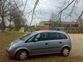
The hash car at the "Bürgerhaus Erbenheim".
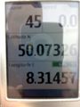
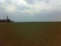
Coordinates reached!
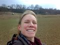
The grin picture and in the background ...
... a sign to for a farm shop.
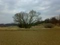
The swampy trees from the hash point,
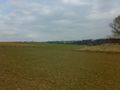
view to Igstadt ...
... and back to Erbenheim.
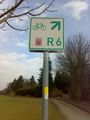
The tack is a popular cycle route ...
... as well as walking trail.
The youth group aT the end of the expedition.


Achievements
LadyBB earned the Land geohash achievement
|