Difference between revisions of "2011-03-09 61 24"
imported>PekkaR |
imported>Jiml m (Seems like someone went, and reached the hashpoint.) |
||
| Line 14: | Line 14: | ||
}} | }} | ||
| − | + | ||
__NOTOC__ | __NOTOC__ | ||
== Location == | == Location == | ||
| − | + | ||
In the Finnish woods in Hattula near road Rannikontie [http://kansalaisen.karttapaikka.fi/linkki?scale=8000&text=hash&srs=EPSG%3A3067&y=6773925&x=355117&lang=fi[Karttapaikka map]]. | In the Finnish woods in Hattula near road Rannikontie [http://kansalaisen.karttapaikka.fi/linkki?scale=8000&text=hash&srs=EPSG%3A3067&y=6773925&x=355117&lang=fi[Karttapaikka map]]. | ||
| Line 24: | Line 24: | ||
== Participants == | == Participants == | ||
| − | + | ||
* [[User:PekkaR|PekkaR]] | * [[User:PekkaR|PekkaR]] | ||
== Plans == | == Plans == | ||
| − | + | ||
Today's hashpoint is quite near my home - about 12 kilometers. I decided go after work to a little snow shoe walk. It was also a good chance to test my new Atlas snow shoes. | Today's hashpoint is quite near my home - about 12 kilometers. I decided go after work to a little snow shoe walk. It was also a good chance to test my new Atlas snow shoes. | ||
---- | ---- | ||
| Line 45: | Line 45: | ||
== Tracklog == | == Tracklog == | ||
| − | + | ||
<gallery perrow="5"> | <gallery perrow="5"> | ||
Image:2011-03-09_61-24_track.gif | Tracklog | Image:2011-03-09_61-24_track.gif | Tracklog | ||
| Line 51: | Line 51: | ||
== Photos == | == Photos == | ||
| − | + | ||
| − | |||
| − | |||
<gallery perrow="5"> | <gallery perrow="5"> | ||
Image: 2011-03-09_61-24_gpsr.jpg | GPSr | Image: 2011-03-09_61-24_gpsr.jpg | GPSr | ||
| − | Image: 2011-03-09_61-24_forest_1.jpg | | + | Image: 2011-03-09_61-24_forest_1.jpg | Forest |
| − | Image: 2011-03-09_61-24_forest_2.jpg | | + | Image: 2011-03-09_61-24_forest_2.jpg | More Forest |
| − | Image: 2011-03-09_61-24_forest_3.jpg | | + | Image: 2011-03-09_61-24_forest_3.jpg | Even more forest |
| − | Image: 2011-03-09_61-24_snowshoe.jpg | | + | Image: 2011-03-09_61-24_snowshoe.jpg | Look, a foot! |
</gallery> | </gallery> | ||
== Achievements == | == Achievements == | ||
{{#vardefine:ribbonwidth|800px}} | {{#vardefine:ribbonwidth|800px}} | ||
| − | + | ||
| + | * Land geohash | ||
| Line 71: | Line 70: | ||
[[Category:New report]] | [[Category:New report]] | ||
| − | |||
| − | |||
| − | |||
| − | |||
| − | |||
[[Category:Expeditions]] | [[Category:Expeditions]] | ||
| − | + | ||
[[Category:Expeditions with photos]] | [[Category:Expeditions with photos]] | ||
| − | |||
| − | |||
| − | |||
| − | + | ||
[[Category:Coordinates reached]] | [[Category:Coordinates reached]] | ||
| − | |||
| − | |||
| − | |||
| − | |||
| − | |||
| − | |||
| − | |||
| − | |||
| − | |||
| − | |||
[[Category:Pages in Finnish]] | [[Category:Pages in Finnish]] | ||
Revision as of 01:52, 21 April 2011
| Wed 9 Mar 2011 in 61,24: 61.0732677, 24.3145703 geohashing.info google osm bing/os kml crox |
Location
In the Finnish woods in Hattula near road Rannikontie [Karttapaikka map].
Suomalaisessa metsässä Hattulassa Rannikontien lähistöllä [Karttapaikka].
Participants
Plans
Today's hashpoint is quite near my home - about 12 kilometers. I decided go after work to a little snow shoe walk. It was also a good chance to test my new Atlas snow shoes.
Päivän hässipiste sattui aika lähelle - noin 12 km kotoa. Päätin töiden jälkeen lähteä pienelle lumikenkäretkelle. Samalla pääsin kokeilemaan uusia Atlas-lumikenkiä.
Expedition
Drive from Hämeenlinna to Hattula didn't take long time. I left my car near Onninen Steel warehouse. I put on my snow shoes and went to to the forest. Sun was already setting. I hiked to the point guided by my Garmin. Surroundings was a typical Finnish woods but very neat like a park. I arrived to the hashpoint at 5:00 pm. I took some photos and turned back to my car. The snow shoes worked well, they are bigger than my old shoes and did not sink to powder snow as much than the old ones.
Onninen Steel warehouse is quite enormous, area of the building is about 25 000 square meters. [Onninen].
Automatka Hämeenlinnasta Hattulaan ei kauaa kestänyt. Jätin auton parkkiin lähellä Onnisen terminaalia. Lumikengät jalkaan ja metsään. Aurinko oli jo aika alhaalla, mutta oli vielä valoisaa. Talsin metsässä gepsin ohjaamana kohti nollapistettä. Maasto oli tyypillistä suomalaista metsää, mutta hyvin hoidettua, puistomaista. Saavuin hässipisteelle klo 17:00. Nollapisteessä piti vähän pyöriä, että GPS pysähtyi näyttämään oikeita lukemia. Otin muutaman kuvan ja lähdin takaisin autolle. Lumikengät toimivat hyvin, ne ovat isommat kuin vanhat muoviläpyskäni ja kantavat paremmin pehmeässä lumessa.
Hässipisteen lähellä oleva Onnisen Teräspalvelukeskus on melko valtava, hallipinta-alaa on yli 25 000 m2 [Onninen].
Tracklog
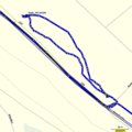
Tracklog

Photos
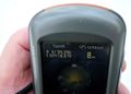
GPSr
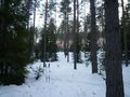
Forest
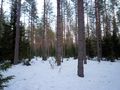
More Forest
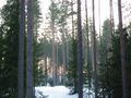
Even more forest
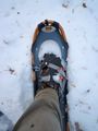
Look, a foot!


Achievements
- Land geohash