Difference between revisions of "2011-03-18 50 8"
imported>Mampfred |
imported>FippeBot m (Location) |
||
| (2 intermediate revisions by one other user not shown) | |||
| Line 1: | Line 1: | ||
| + | {{advert|image = 2011-03-18_50_8_marker.jpg}} | ||
{{meetup graticule | {{meetup graticule | ||
| lat=50 | | lat=50 | ||
| Line 14: | Line 15: | ||
== Plans == | == Plans == | ||
| − | Quick outing on a | + | Quick outing on a friday afternoon, will leave soon(tm). |
== Expedition == | == Expedition == | ||
| − | + | Exactly as planned, drove most of the way but decided to have a walk for the last kilometer or so. Parked near a sports ground and found the hash just outside the woods in front of a (very) little field. There was a stand right next to it, too bad it wasn't on top of it or we could have qualified for a [[Stacking achievement]]. Took some photos and headed back home. | |
== Tracklog == | == Tracklog == | ||
| − | + | See [http://www.everytrail.com/view_trip.php?trip_id=1003494 here]. | |
== Photos == | == Photos == | ||
| − | |||
| − | |||
| − | |||
<gallery perrow="5"> | <gallery perrow="5"> | ||
| + | Image:2011-03-18_50_8_parked.jpg | Parked the car near a ... | ||
| + | Image:2011-03-18_50_8_sports_ground.jpg | ... sports ground - and what an important one (see next photo). | ||
| + | Image:2011-03-18_50_8_sign.jpg | Seriously. If you even attempt to play here you WILL BE prosecuted. Or killed. Or both. ("This sports ground belongs to the city of Altenhain. Any playing without official approval is strongly forbidden.") | ||
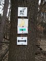
| + | Image:2011-03-18_50_8_this_way.jpg | I'm thinking this sign will lead us to the hash. Any hash in fact. | ||
| + | Image:2011-03-18_50_8_still_this_way.jpg | Yep, still on the right track. | ||
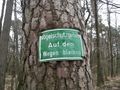
| + | Image:2011-03-18_50_8_stay.jpg | Bird-preservation area. Stay on the track. Luckily to our left, the hash was on the right of the track. | ||
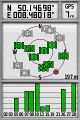
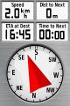
| + | Image:2011-03-18_50_8_coordinates.jpg | Coordinates ... | ||
| + | Image:2011-03-18_50_8_reached.jpg | ... reached. | ||
| + | Image:2011-03-18_50_8_still_south_east.jpg | View to the south east of the hash. | ||
| + | Image:2011-03-18_50_8_still_south_west.jpg | View to the south west of the hash. | ||
| + | Image:2011-03-18_50_8_hash_outlook.jpg | Look, a stand right next to the hash. | ||
| + | Image:2011-03-18_50_8_ladybb.jpg | Looking from the stand down on LadyBB and the hash. | ||
| + | Image:2011-03-18_50_8_grin.jpg | Stupid Grin(tm). | ||
| + | Image:2011-03-18_50_8_marker.jpg | We also left a marker on the stand. | ||
</gallery> | </gallery> | ||
== Achievements == | == Achievements == | ||
{{#vardefine:ribbonwidth|800px}} | {{#vardefine:ribbonwidth|800px}} | ||
| − | + | {{Land geohash | |
| + | | latitude = 50 | ||
| + | | longitude = 8 | ||
| + | | date = 2011-03-18 | ||
| + | | name = [[User:Mampfred|Mampfred]] and [[User:LadyBB|LadyBB]] | ||
| + | }} | ||
| − | |||
| − | |||
| − | |||
[[Category:Expeditions]] | [[Category:Expeditions]] | ||
| − | |||
[[Category:Expeditions with photos]] | [[Category:Expeditions with photos]] | ||
| − | |||
| − | |||
| − | |||
| − | |||
| − | |||
[[Category:Coordinates reached]] | [[Category:Coordinates reached]] | ||
| − | + | {{location|DE|HE|MTK}} | |
| − | |||
| − | |||
| − | |||
| − | |||
| − | |||
| − | |||
| − | |||
| − | |||
| − | |||
Latest revision as of 05:52, 9 August 2019
| Have you seen our geohashing marker? We'd love to hear from you! Click here to say "hi" and tell us what you've seen!
Curious about what geohashing is? Read more! |  |
| Fri 18 Mar 2011 in 50,8: 50.1469812, 8.4801805 geohashing.info google osm bing/os kml crox |
Location
In the woods near Bad Soden.
Participants
Plans
Quick outing on a friday afternoon, will leave soon(tm).
Expedition
Exactly as planned, drove most of the way but decided to have a walk for the last kilometer or so. Parked near a sports ground and found the hash just outside the woods in front of a (very) little field. There was a stand right next to it, too bad it wasn't on top of it or we could have qualified for a Stacking achievement. Took some photos and headed back home.
Tracklog
See here.
Photos
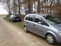
Parked the car near a ...
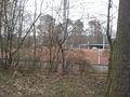
... sports ground - and what an important one (see next photo).
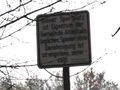
Seriously. If you even attempt to play here you WILL BE prosecuted. Or killed. Or both. ("This sports ground belongs to the city of Altenhain. Any playing without official approval is strongly forbidden.")
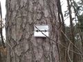
I'm thinking this sign will lead us to the hash. Any hash in fact.
Yep, still on the right track.
Bird-preservation area. Stay on the track. Luckily to our left, the hash was on the right of the track.
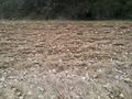
Coordinates ...
... reached.
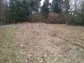
View to the south east of the hash.
View to the south west of the hash.
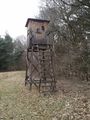
Look, a stand right next to the hash.
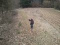
Looking from the stand down on LadyBB and the hash.

Stupid Grin(tm).
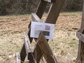
We also left a marker on the stand.


Achievements
Mampfred and LadyBB earned the Land geohash achievement
|