Difference between revisions of "2011-03-19 43 27"
imported>Kisolre (Created page with "{{subst:Expedition |lat = 43 |lon = 27 |date = 2011-03-19 }}") |
imported>Kisolre |
||
| Line 1: | Line 1: | ||
| − | |||
<!-- If you did not specify these parameters in the template, please substitute appropriate values for IMAGE, LAT, LON, and DATE (YYYY-MM-DD format) | <!-- If you did not specify these parameters in the template, please substitute appropriate values for IMAGE, LAT, LON, and DATE (YYYY-MM-DD format) | ||
| Line 15: | Line 14: | ||
}} | }} | ||
| − | |||
__NOTOC__ | __NOTOC__ | ||
== Location == | == Location == | ||
| − | + | In a field near the road from the highway to [http://bg.wikipedia.org/wiki/%D0%92%D0%B5%D1%82%D1%80%D0%B8%D0%BD%D0%BE Vetrino] village. | |
== Participants == | == Participants == | ||
| − | + | [[User:kisolre|Kisolre]] | |
| − | == | + | == Expedition == |
| − | + | Since friday, saturday and sunday hashes come at once I checked all 3 days and found them easily reachable. So I decided to go for some achievements in bulk. | |
| − | + | Today's expedition was by car. I loaded gas and drove to the field. At the main road I saw a flock of storks and took a picture of them. Since the hash was some 700m from the main road I drove on a near dirt road to get near. The field has been tilthed recently and I had to change my boots to a more sturdy ones which I had brought just in case. I took some fotos, planted a stick with a geohashing card and headed back home. | |
| − | |||
| − | + | Once at home I realised that I drove some 70+ km just to reach the hash and it was fuel for nothing :( So I decided to try to never do that again. Just for this 3 hashes. After that if no meaningful reason to go there then don't go. | |
| − | |||
== Photos == | == Photos == | ||
| − | < | + | <gallery perrow="4"> |
| − | Image: | + | Image:2011-03-19_Storks.jpg | Storks by the road |
| − | -- | + | Image:2011-03-19_43_27_Field.jpg | The field fo the hash |
| − | + | Image:2011-03-19_43_27_Proof.jpg | Proof | |
| + | Image:2011-03-19_43_27_Kisolre.jpg | Me at the hash | ||
| + | Image:2011-03-19_43_27_Card.jpg | Geohashing card | ||
</gallery> | </gallery> | ||
| − | |||
| − | |||
| − | |||
| − | |||
| − | |||
| − | |||
| − | |||
| − | |||
| − | |||
| − | |||
| − | |||
| − | |||
| − | |||
| − | |||
| − | |||
[[Category:Expeditions]] | [[Category:Expeditions]] | ||
| − | |||
[[Category:Expeditions with photos]] | [[Category:Expeditions with photos]] | ||
| − | |||
| − | |||
| − | |||
| − | |||
| − | |||
[[Category:Coordinates reached]] | [[Category:Coordinates reached]] | ||
| − | |||
| − | |||
| − | |||
| − | |||
| − | |||
| − | |||
| − | |||
| − | |||
| − | |||
| − | |||
Revision as of 09:59, 23 March 2011
| Sat 19 Mar 2011 in 43,27: 43.2779449, 27.4288261 geohashing.info google osm bing/os kml crox |
Location
In a field near the road from the highway to Vetrino village.
Participants
Expedition
Since friday, saturday and sunday hashes come at once I checked all 3 days and found them easily reachable. So I decided to go for some achievements in bulk.
Today's expedition was by car. I loaded gas and drove to the field. At the main road I saw a flock of storks and took a picture of them. Since the hash was some 700m from the main road I drove on a near dirt road to get near. The field has been tilthed recently and I had to change my boots to a more sturdy ones which I had brought just in case. I took some fotos, planted a stick with a geohashing card and headed back home.
Once at home I realised that I drove some 70+ km just to reach the hash and it was fuel for nothing :( So I decided to try to never do that again. Just for this 3 hashes. After that if no meaningful reason to go there then don't go.
Photos
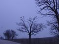
Storks by the road
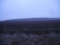
The field fo the hash
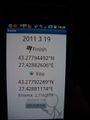
Proof

Me at the hash
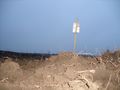
Geohashing card


