Difference between revisions of "2011-03-19 50 8"
imported>Mampfred (Created page with "{{meetup graticule | lat=50 | lon=8 | date=2011-03-19 }} __NOTOC__ == Location == In the woods ... somewhere. == Participants == *Mampfred *[[User:LadyBB|Lad...") |
imported>Mampfred |
||
| Line 7: | Line 7: | ||
__NOTOC__ | __NOTOC__ | ||
== Location == | == Location == | ||
| − | In the woods | + | In the hills in the "Höllenwald" ("hell-woods") between Schmitten and Finsternthal. |
== Participants == | == Participants == | ||
| Line 17: | Line 17: | ||
== Expedition == | == Expedition == | ||
| − | + | Little walk, ey? We drove to Schmitten as this was the closest town according to our Falk navigation system. We realized that we wouldn't get close enough so we tried what Google was suggesting in the first place to approach the hash from Finsternthal and walk up the "Schmitter Weg". | |
| + | |||
| + | Stopped when the road became too dirty and walked the rest of the way. The hash was about 200 meters into the woods up a hill, you can see this nicely in the track log. We walked about 3.7km with a change of elevation of about 170 meters up and down again. Very nice weather, lots of sun, a little snow on top of the mountain, great hobby. | ||
== Tracklog == | == Tracklog == | ||
| − | + | See [http://www.everytrail.com/view_trip.php?trip_id=1004277 here]. | |
== Photos == | == Photos == | ||
| − | |||
| − | |||
| − | |||
<gallery perrow="5"> | <gallery perrow="5"> | ||
| + | Image:2011-03-19_50_8_track.jpg | Parking on the "Schmittener Weg". LadyBB preparing for the walk. | ||
| + | Image:2011-03-19_50_8_sign.jpg | Hmm, this reminds me of the sign [[2011-03-18 50 8|yesterday]] ;) | ||
| + | Image:2011-03-19_50_8_look_at_hash_from_track.jpg | The hash must be up there somewhere. | ||
| + | Image:2011-03-19_50_8_coordinates.jpg | Coordinates ... | ||
| + | Image:2011-03-19_50_8_reached.jpg | ... reached. | ||
| + | Image:2011-03-19_50_8_hash.jpg | "The hash" | ||
| + | Image:2011-03-19_50_8_from_the_hash_to_the_top.jpg | Looking from the hash to the rest of the way to the top of the crest. | ||
| + | Image:2011-03-19_50_8_grin.jpg | Stupid grin with the hash in the background. | ||
| + | Image:2011-03-19_50_8_what_goes_up_has_to_go_down.jpg | Shame the photo can't convey how steep it is and how far we climbed here. | ||
| + | Image:2011-03-19_50_8_snow_ans_sun.jpg | Snow in front, sun in the back, how nice. | ||
| + | Image:2011-03-19_50_8_sunny.jpg | What a sunny day. | ||
| + | Image:2011-03-19_50_8_sunnier.jpg | Even sunnier. | ||
| + | Image:2011-03-19_50_8_sunny_day_again.jpg | ... | ||
</gallery> | </gallery> | ||
== Achievements == | == Achievements == | ||
{{#vardefine:ribbonwidth|800px}} | {{#vardefine:ribbonwidth|800px}} | ||
| − | + | {{Consecutive_geohash | |
| − | + | | latitude = 50 | |
| − | + | | longitude = 8 | |
| − | [[ | + | | count = 2 |
| + | | date = 2011-03-18 | ||
| + | | name = Mampfred and LadyBB | ||
| + | }} | ||
| + | {{Land geohash | ||
| + | | latitude = 50 | ||
| + | | longitude = 8 | ||
| + | | date = 2011-03-19 | ||
| + | | name = [[User:Mampfred|Mampfred]] and [[User:LadyBB|LadyBB]] | ||
| + | }} | ||
| − | |||
[[Category:Expeditions]] | [[Category:Expeditions]] | ||
| − | |||
[[Category:Expeditions with photos]] | [[Category:Expeditions with photos]] | ||
| − | |||
| − | |||
| − | |||
| − | |||
| − | |||
[[Category:Coordinates reached]] | [[Category:Coordinates reached]] | ||
| − | |||
| − | |||
| − | |||
| − | |||
| − | |||
| − | |||
| − | |||
| − | |||
| − | |||
| − | |||
Revision as of 13:45, 19 March 2011
| Sat 19 Mar 2011 in 50,8: 50.2779449, 8.4288261 geohashing.info google osm bing/os kml crox |
Location
In the hills in the "Höllenwald" ("hell-woods") between Schmitten and Finsternthal.
Participants
Plans
Little walk in the morning before we get some guests in the afternoon.
Expedition
Little walk, ey? We drove to Schmitten as this was the closest town according to our Falk navigation system. We realized that we wouldn't get close enough so we tried what Google was suggesting in the first place to approach the hash from Finsternthal and walk up the "Schmitter Weg".
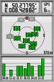
Stopped when the road became too dirty and walked the rest of the way. The hash was about 200 meters into the woods up a hill, you can see this nicely in the track log. We walked about 3.7km with a change of elevation of about 170 meters up and down again. Very nice weather, lots of sun, a little snow on top of the mountain, great hobby.
Tracklog
See here.
Photos
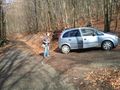
Parking on the "Schmittener Weg". LadyBB preparing for the walk.
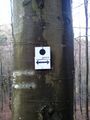
Hmm, this reminds me of the sign yesterday ;)
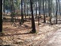
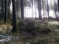
The hash must be up there somewhere.
Coordinates ...
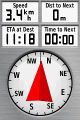
... reached.
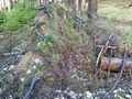
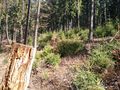
"The hash"
Looking from the hash to the rest of the way to the top of the crest.
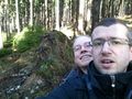
Stupid grin with the hash in the background.
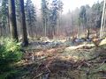
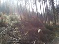
Shame the photo can't convey how steep it is and how far we climbed here.
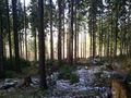
Snow in front, sun in the back, how nice.
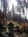
What a sunny day.
Even sunnier.
...


Achievements
Mampfred and LadyBB earned the Consecutive geohash achievement
|
Mampfred and LadyBB earned the Land geohash achievement
|