Difference between revisions of "2011-03-23 50 4"
imported>Lemming (→Participants) |
imported>FippeBot m (Location) |
||
| (6 intermediate revisions by 2 users not shown) | |||
| Line 1: | Line 1: | ||
| − | + | [[Image:{{{image|2011_03_23_50_4_3_Abdij_van_'t_Park.jpg}}}|thumb|left]] | |
| − | |||
| − | |||
| − | |||
| − | |||
| − | |||
| − | |||
| − | |||
{{meetup graticule | {{meetup graticule | ||
| lat=50 | | lat=50 | ||
| Line 14: | Line 7: | ||
}} | }} | ||
| − | |||
__NOTOC__ | __NOTOC__ | ||
== Location == | == Location == | ||
| − | |||
Tivolistraat in Heverlee (Leuven), a small road next to the railway. | Tivolistraat in Heverlee (Leuven), a small road next to the railway. | ||
== Participants == | == Participants == | ||
| − | [[User:Lemming|Lemming]] | + | * [[User:Lemming|Lemming]] |
== Plans == | == Plans == | ||
| − | |||
Trying to get there before sunset, for a nice photo. 18:45 is the earliest possible for [[User:Lemming|Lemming]]. | Trying to get there before sunset, for a nice photo. 18:45 is the earliest possible for [[User:Lemming|Lemming]]. | ||
== Expedition == | == Expedition == | ||
| − | + | As Wednesday's geohash was rather close to my home, I picked this one as my very first geohashing trip. I took my camera to work, so I could walk to the target directly from the train station after my evening commute. In the end I needed about 25 minutes to get there, as I took time to take pictures. Afterwards I walked 150 m more to visit a friends house :-) No [[drag-along achievement]] because the friend was home alone with his child... So my first geohash expedition was a short one, but it was a fun thing to do. I'll certainly will try this again in the future. | |
| − | |||
| − | |||
| − | |||
== Photos == | == Photos == | ||
| − | < | + | <gallery> |
| − | Image: | + | Image:2011_03_23_50_4_1_office_buildings.jpg | Walking away from the dead trees |
| − | + | Image:2011_03_23_50_4_2_blossom.jpg | Towards the blossoming ones | |
| − | + | Image:2011_03_23_50_4_3_Abdij_van_'t_Park.jpg | Abdij van 't Park (abbey) | |
| + | Image:2011_03_23_50_4_4_geohash_reached.jpg | Someone left an iPhone | ||
| + | Image:2011_03_23_50_4_5_sunset.jpg | Sunset | ||
| + | Image:2011_03_23_50_4_6_sunset_railroad.jpg | Sunset railroad | ||
</gallery> | </gallery> | ||
== Achievements == | == Achievements == | ||
{{#vardefine:ribbonwidth|800px}} | {{#vardefine:ribbonwidth|800px}} | ||
| − | + | {{land geohash | |
| − | + | | latitude = 50 | |
| − | + | | longitude = 4 | |
| − | + | | date = 2011-03-23 | |
| − | + | | name = [[User:Lemming|Lemming]] | |
| − | [[ | + | }} |
| − | |||
| − | |||
| − | |||
| − | |||
| − | |||
| − | |||
[[Category:Expeditions]] | [[Category:Expeditions]] | ||
| − | |||
[[Category:Expeditions with photos]] | [[Category:Expeditions with photos]] | ||
| − | |||
| − | |||
| − | |||
| − | |||
| − | |||
[[Category:Coordinates reached]] | [[Category:Coordinates reached]] | ||
| − | + | {{location|BE|VBR}} | |
| − | |||
| − | |||
| − | |||
| − | |||
| − | |||
| − | |||
| − | |||
| − | |||
| − | |||
Latest revision as of 05:58, 9 August 2019

| Wed 23 Mar 2011 in 50,4: 50.8654680, 4.7129840 geohashing.info google osm bing/os kml crox |
Location
Tivolistraat in Heverlee (Leuven), a small road next to the railway.
Participants
Plans
Trying to get there before sunset, for a nice photo. 18:45 is the earliest possible for Lemming.
Expedition
As Wednesday's geohash was rather close to my home, I picked this one as my very first geohashing trip. I took my camera to work, so I could walk to the target directly from the train station after my evening commute. In the end I needed about 25 minutes to get there, as I took time to take pictures. Afterwards I walked 150 m more to visit a friends house :-) No drag-along achievement because the friend was home alone with his child... So my first geohash expedition was a short one, but it was a fun thing to do. I'll certainly will try this again in the future.
Photos

Walking away from the dead trees

Towards the blossoming ones
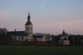
Abdij van 't Park (abbey)
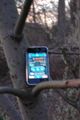
Someone left an iPhone
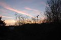
Sunset
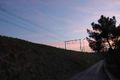
Sunset railroad


Achievements
Lemming earned the Land geohash achievement
|