Difference between revisions of "2011-03-24 42 -71"
imported>Shishire |
imported>FippeBot m (Location) |
||
| (4 intermediate revisions by 3 users not shown) | |||
| Line 1: | Line 1: | ||
| − | |||
| − | |||
| − | |||
| − | |||
| − | |||
| − | |||
| − | |||
| − | |||
| − | |||
{{meetup graticule | {{meetup graticule | ||
| lat=42 | | lat=42 | ||
| Line 14: | Line 5: | ||
}} | }} | ||
| − | |||
__NOTOC__ | __NOTOC__ | ||
== Location == | == Location == | ||
| Line 27: | Line 17: | ||
== Expedition == | == Expedition == | ||
Today's was fairly easy. It was in the middle of a residential neighborhood, down one of many side streets. I pulled up at the location after a couple minutes, and found that the coordinates placed the point in someone's yard. I stopped my car and got out, but I decided against trespassing. I got 22 feet from the coordinates, and I have a photo with EXIF to prove it. Also, it turns out that the GeoHash Droid application is really useful if you've got an android device. | Today's was fairly easy. It was in the middle of a residential neighborhood, down one of many side streets. I pulled up at the location after a couple minutes, and found that the coordinates placed the point in someone's yard. I stopped my car and got out, but I decided against trespassing. I got 22 feet from the coordinates, and I have a photo with EXIF to prove it. Also, it turns out that the GeoHash Droid application is really useful if you've got an android device. | ||
| − | |||
| − | |||
| − | |||
== Photos == | == Photos == | ||
| − | |||
| − | |||
| − | |||
<gallery perrow="5"> | <gallery perrow="5"> | ||
| − | |||
Image:2011-03-24_42_-71_15-55-34-137.jpg | Just made it here. Today's coordinates were 3 miles from my work, so I stopped by on lunch. It's snowing, even though you can't see in the picture. [http://www.openstreetmap.org/?lat=42.5277&lon=-71.1152&zoom=16&layers=B000FTF @42.5277,-71.1152] | Image:2011-03-24_42_-71_15-55-34-137.jpg | Just made it here. Today's coordinates were 3 miles from my work, so I stopped by on lunch. It's snowing, even though you can't see in the picture. [http://www.openstreetmap.org/?lat=42.5277&lon=-71.1152&zoom=16&layers=B000FTF @42.5277,-71.1152] | ||
| + | Image:2011-03-24_42_-71_17-07-33-502.jpg | Mandatory Grin | ||
</gallery> | </gallery> | ||
== Achievements == | == Achievements == | ||
{{#vardefine:ribbonwidth|800px}} | {{#vardefine:ribbonwidth|800px}} | ||
| − | |||
| + | * Land Geohash | ||
| − | |||
| − | |||
| − | |||
| − | |||
| − | |||
| − | |||
| − | |||
| − | |||
| − | |||
[[Category:Expeditions]] | [[Category:Expeditions]] | ||
| − | |||
[[Category:Expeditions with photos]] | [[Category:Expeditions with photos]] | ||
| − | |||
| − | |||
| − | |||
| − | |||
| − | |||
[[Category:Coordinates reached]] | [[Category:Coordinates reached]] | ||
| − | + | {{location|US|MA|MI}} | |
| − | |||
| − | |||
| − | |||
| − | |||
| − | |||
| − | |||
| − | |||
| − | |||
| − | |||
Latest revision as of 05:58, 9 August 2019
| Thu 24 Mar 2011 in 42,-71: 42.5277437, -71.1152577 geohashing.info google osm bing/os kml crox |
Location
Today's hash was located on right off the street, in what appears to be either a side or back yard.
Participants
Plans
I checked today's coordinates as I was getting ready to leave work for lunch, and discovered, to my surprise that they were located about 3 miles from my work. So I decided to swing by after I ate, take the mandatory photo, and see how it turned out.
Expedition
Today's was fairly easy. It was in the middle of a residential neighborhood, down one of many side streets. I pulled up at the location after a couple minutes, and found that the coordinates placed the point in someone's yard. I stopped my car and got out, but I decided against trespassing. I got 22 feet from the coordinates, and I have a photo with EXIF to prove it. Also, it turns out that the GeoHash Droid application is really useful if you've got an android device.
Photos
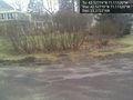
Just made it here. Today's coordinates were 3 miles from my work, so I stopped by on lunch. It's snowing, even though you can't see in the picture. @42.5277,-71.1152

Mandatory Grin


Achievements
- Land Geohash