Difference between revisions of "2011-03-24 49 8"
imported>Ilpadre (tracklog) |
imported>FippeBot m (Location) |
||
| (6 intermediate revisions by one other user not shown) | |||
| Line 9: | Line 9: | ||
Between Peterstal (since 1975 a part of Heidelberg, the point itself is close to Heidelberg's northernmost point) and Wilhelmsfeld, near a street, in very steep terrain. | Between Peterstal (since 1975 a part of Heidelberg, the point itself is close to Heidelberg's northernmost point) and Wilhelmsfeld, near a street, in very steep terrain. | ||
| − | |||
| − | |||
| − | |||
== Participants == | == Participants == | ||
| Line 18: | Line 15: | ||
== Expedition == | == Expedition == | ||
| − | - | + | '''Expedition total:''' 3 hours, walked 26 km. |
| + | |||
| + | This expedition was this month's tenth expedition in the Mannheim graticule. March 2011 is now the month with the most expeditions in 49 8 since the beginning of geohashing! | ||
| + | |||
| + | When on Wednesday I realized the coordinates were only about 13 km from central Heidelberg, I immediately started to think about a walk expedition. It both fitted into my current training regime and would beat my personal best walk expedition distance. The coordinates also looked very accessible on Google's satellite images. On top of that, the weather was sunny and warm, and I had enough time in the evening to start early in order to be back home before it would be getting dark. | ||
| + | |||
| + | I started the expedition a little later than planned, but everything else went fine. I'm suffering from shin splints since a few weeks, but the pain didn't get worse during the run (maybe also due to some kinesio taping). When I left the sunny Neckar valley to run towards Peterstal, it got significantly colder - the sun must have left the valley hours ago. The street led uphill, and I soon approached the coordinates. They were not close to the street, as I had hoped, but seemed to be about 10 or 20 m next to it - between trees, and in very steep terrain. It wasn't safe to enter the forest in a 90 degree angle towards the hashpoint, as the risk of slipping and falling back on the street would have been too great. So I searched for a more convenient point to climb up, and soon found the coordinates, event though satellite reception was really bad in the valley unter all those trees. | ||
| + | |||
| + | When I was back down at the Neckar, the sky was getting orange and I realized that due to my late start of the expedition I had no chance to be back in Heidelberg to take some pictures of the setting sun. Instead, I was greeted by bats hunting insects in the twilight. I still managed to take some pictures of the gradually dimming, atmospheric post-sunset light near the Old Bridge. When I returned home exactly 3 hours after I left, it was almost dark, and I realized that this expedition was my longest run in about 7 years. | ||
== Tracklog == | == Tracklog == | ||
| Line 27: | Line 32: | ||
<gallery> | <gallery> | ||
| + | File:2011-03-24 49 8 neckarwiese.jpg|Every time the sun comes out, it soon gets crowded here. | ||
| + | File:2011-03-24 49 8 neckar.jpg|Still a beautiful sight, even after six years of living in Heidelberg. | ||
| + | File:2011-03-24 49 8 baustelle.jpg|The traffic on that road is restricted by extensive construction work. | ||
| + | File:2011-03-24 49 8 geese.jpg|A pair of geese. | ||
| + | File:2011-03-24 49 8 stift.jpg|A Benedictine monastery. | ||
| + | File:2011-03-24 49 8 lefthere.jpg|Leaving the Nackar to turn left here. | ||
| + | File:2011-03-24 49 8 peterstal.jpg|"Peterstal greets you all." | ||
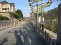
| + | File:2011-03-24 49 8 approaching.jpg|Getting closer. The point is somewhere to the left. | ||
| + | File:2011-03-24 49 8 stupidgrin.jpg|Obligatory. | ||
| + | File:2011-03-24 49 8 west.jpg|At the hashpoint, looking west. | ||
| + | File:2011-03-24 49 8 sunset.jpg|Back at the Neckar. | ||
| + | File:2011-03-24 49 8 bat.jpg|They were much too fast for me. | ||
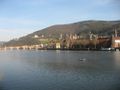
| + | File:2011-03-24 49 8 panorama1.jpg|Heidelberg's treasured Old Bridge, built in the 1780s, destroyed by the Wehrmacht in 1945, then rebuilt. | ||
| + | File:2011-03-24 49 8 panorama2.jpg|Standing on that bridge. | ||
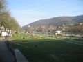
| + | File:2011-03-24 49 8 skatepark.jpg|Building a skatepark. | ||
| + | File:2011-03-24 49 8 2h59min59s.jpg|Back home after 3 hours. | ||
</gallery> | </gallery> | ||
| Line 33: | Line 54: | ||
[[Category:Expeditions with photos]] | [[Category:Expeditions with photos]] | ||
[[Category:Coordinates reached]] | [[Category:Coordinates reached]] | ||
| + | {{location|DE|BW|HD|city=true}} | ||
Latest revision as of 05:59, 9 August 2019
| Thu 24 Mar 2011 in 49,8: 49.4534780, 8.7590657 geohashing.info google osm bing/os kml crox |
Location
Between Peterstal (since 1975 a part of Heidelberg, the point itself is close to Heidelberg's northernmost point) and Wilhelmsfeld, near a street, in very steep terrain.
Participants
Expedition
Expedition total: 3 hours, walked 26 km.
This expedition was this month's tenth expedition in the Mannheim graticule. March 2011 is now the month with the most expeditions in 49 8 since the beginning of geohashing!
When on Wednesday I realized the coordinates were only about 13 km from central Heidelberg, I immediately started to think about a walk expedition. It both fitted into my current training regime and would beat my personal best walk expedition distance. The coordinates also looked very accessible on Google's satellite images. On top of that, the weather was sunny and warm, and I had enough time in the evening to start early in order to be back home before it would be getting dark.
I started the expedition a little later than planned, but everything else went fine. I'm suffering from shin splints since a few weeks, but the pain didn't get worse during the run (maybe also due to some kinesio taping). When I left the sunny Neckar valley to run towards Peterstal, it got significantly colder - the sun must have left the valley hours ago. The street led uphill, and I soon approached the coordinates. They were not close to the street, as I had hoped, but seemed to be about 10 or 20 m next to it - between trees, and in very steep terrain. It wasn't safe to enter the forest in a 90 degree angle towards the hashpoint, as the risk of slipping and falling back on the street would have been too great. So I searched for a more convenient point to climb up, and soon found the coordinates, event though satellite reception was really bad in the valley unter all those trees.
When I was back down at the Neckar, the sky was getting orange and I realized that due to my late start of the expedition I had no chance to be back in Heidelberg to take some pictures of the setting sun. Instead, I was greeted by bats hunting insects in the twilight. I still managed to take some pictures of the gradually dimming, atmospheric post-sunset light near the Old Bridge. When I returned home exactly 3 hours after I left, it was almost dark, and I realized that this expedition was my longest run in about 7 years.
Tracklog
http://www.everytrail.com/view_trip.php?trip_id=1011770 (bad reception during large parts of the trip)
Photos
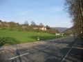
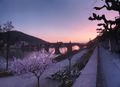
Every time the sun comes out, it soon gets crowded here.
Still a beautiful sight, even after six years of living in Heidelberg.
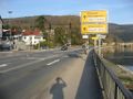
The traffic on that road is restricted by extensive construction work.
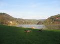
A pair of geese.
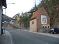
A Benedictine monastery.
Leaving the Nackar to turn left here.
"Peterstal greets you all."
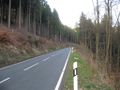
Getting closer. The point is somewhere to the left.
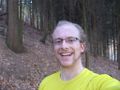
Obligatory.
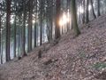
At the hashpoint, looking west.
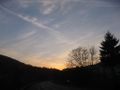
Back at the Neckar.
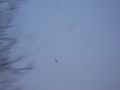
They were much too fast for me.
Heidelberg's treasured Old Bridge, built in the 1780s, destroyed by the Wehrmacht in 1945, then rebuilt.
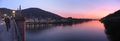
Standing on that bridge.
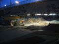
Building a skatepark.
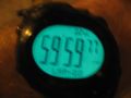
Back home after 3 hours.


