Difference between revisions of "2011-03-27 46 6"
imported>TheOneRing (→Location) |
imported>TheOneRing |
||
| Line 11: | Line 11: | ||
[[User:TheOneRing|TheOneRing]] - by public transport. | [[User:TheOneRing|TheOneRing]] - by public transport. | ||
| − | == The | + | == The Expedition == |
| − | + | === TheOneRing === | |
| + | The weather conditions were really good at the beginning: warm, but a mix of sun and clouds. That's why I decided to go to the hash. | ||
| + | |||
| + | I went by train to Neuchâtel and from there to Fleurier. The geohash itself was only approx. 2.5km (as the bird flies) away from the train station, but I had to walk 4.5km in total because the difference in altutude was 300m, considering that I was in the Jura mountains. I passed some interesting rock formations on the way. | ||
| + | |||
| + | After a certain time I reached a forest where I expected the geohash to be. On my way I saw an abandoned bus. It brought the movie '''Into the wild''' and the story of Christopher McCandless into my mind. At the geohash I took the usual photos, had a small lunch and walked back to Fleurier. I left a marker at the geohash, which is completely bio-degradable. | ||
| + | |||
| + | Just when I entered the train to Neuchâtel it started to rain a bit, so I was lucky in the end. | ||
| + | |||
| + | == Photos == | ||
| + | === TheOneRing === | ||
| + | <gallery perrow="6"> | ||
| + | Image:20110327SaintSulpice.jpg|The village of Saint Sulpice near Fleurier | ||
| + | Image:20110327Formation.jpg|Mosaic of a rock formation | ||
| + | Image:20110327Geohash1.jpg|My eTrex marks the geohash | ||
| + | Image:20110327Geohash2.jpg|Close-up from before | ||
| + | Image:20110327GPS.jpg|Proof that I reached the right coordinates... | ||
| + | Image:20110327Ticket.jpg|...on the right date | ||
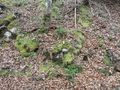
| + | Image:20110327Marker.jpg|An ecological marker at the geohash | ||
| + | Image:20110327StupidGrin.jpg|An exhausted, but happy StupidGrin | ||
| + | Image:20110327Surroundig2.jpg|View up... | ||
| + | Image:20110327Surroundig1.jpg|...and down the way | ||
| + | Image:20110327Surroundig3.jpg|Fortunately the geohash wasn't 5m this way | ||
| + | Image:20110327Bus.jpg|An abandoned bus | ||
| + | </gallery> | ||
| + | |||
| + | == Achievements == | ||
| + | {{land geohash | latitude = 47 | longitude = 7 | date = 2011-02-26 | name = TheOneRing }} | ||
| + | {{Public transport geohash | latitude = 47 | longitude = 7 | date = 2011-02-26 | name = TheOneRing}} | ||
| + | {{Minesweeper geohash | graticule = Bern, Switzerland | ranknumber = 4 | e = true | ne = true | n = true | w = true | name = TheOneRing }} | ||
| + | {{Minesweeper geohash | graticule = Basel, Switzerland | ranknumber = 4 | se = true | e = true | s = true | sw = true | name = TheOneRing }} | ||
| + | |||
| + | [[Category:Expeditions]] | ||
| + | [[Category:Expeditions with photos]] | ||
| + | [[Category:Coordinates reached]] | ||
Revision as of 16:48, 27 March 2011
| Sun 27 Mar 2011 in 46,6: 46.9159722, 6.5487657 geohashing.info google osm bing/os kml crox |
Contents
Location
The geohash is in a forest near the village of Fleurier (canton Neuchâtel), only approx. 7km from the border to France.
Who Went
TheOneRing - by public transport.
The Expedition
TheOneRing
The weather conditions were really good at the beginning: warm, but a mix of sun and clouds. That's why I decided to go to the hash.
I went by train to Neuchâtel and from there to Fleurier. The geohash itself was only approx. 2.5km (as the bird flies) away from the train station, but I had to walk 4.5km in total because the difference in altutude was 300m, considering that I was in the Jura mountains. I passed some interesting rock formations on the way.
After a certain time I reached a forest where I expected the geohash to be. On my way I saw an abandoned bus. It brought the movie Into the wild and the story of Christopher McCandless into my mind. At the geohash I took the usual photos, had a small lunch and walked back to Fleurier. I left a marker at the geohash, which is completely bio-degradable.
Just when I entered the train to Neuchâtel it started to rain a bit, so I was lucky in the end.
Photos
TheOneRing
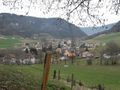
The village of Saint Sulpice near Fleurier
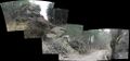
Mosaic of a rock formation
My eTrex marks the geohash
Close-up from before
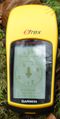
Proof that I reached the right coordinates...
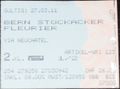
...on the right date
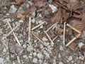
An ecological marker at the geohash

An exhausted, but happy StupidGrin
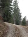
View up...
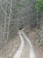
...and down the way
Fortunately the geohash wasn't 5m this way
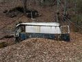
An abandoned bus


Achievements
TheOneRing earned the Land geohash achievement
|
TheOneRing earned the Public transport geohash achievement
|
TheOneRing achieved level 4 of the Minesweeper Geohash achievement
|
TheOneRing achieved level 4 of the Minesweeper Geohash achievement
|