Difference between revisions of "2011-03-30 33 -83"
imported>FippeBot m (Location) |
|||
| (11 intermediate revisions by 2 users not shown) | |||
| Line 45: | Line 45: | ||
I danced the GPS around for about 15 minutes and found out how frustrating technology can be. My GPS is a cheap automobile unit. The refresh on the location is slow and jumpy. The whole dance was in water over the tops of my shoes. | I danced the GPS around for about 15 minutes and found out how frustrating technology can be. My GPS is a cheap automobile unit. The refresh on the location is slow and jumpy. The whole dance was in water over the tops of my shoes. | ||
| − | I took some pictures of the site including the GPS readout, a shot of the hill that I would climb to leave, and a Stupid Grin photo. Found a carnivore skull in the ground cover near the hash. The area was quite beautiful and quiet. I did get a scare when I heard a loud crash nearby (deer? bear? ''raptor''?). I figured I did as well as could be expected for my first time out so I slogged my way back to the car. The trip home was fine except for the wet feet. | + | I took some pictures of the site including the GPS readout, a shot of the hill that I would climb to leave, and a Stupid Grin photo. Found a carnivore skull in the ground cover near the hash. The area was quite beautiful and quiet. I did get a scare when I heard a loud crash nearby (deer? bear? ''raptor''?). I figured I did as well as could be expected for my first time out so I slogged my way back to the car. I left behind a small tag attached to a tree as the only impact of my visit. The trip home was fine except for the wet feet. Round trip travel about 140 miles, 3.5 hours. |
== Photos == | == Photos == | ||
| Line 52: | Line 52: | ||
--> | --> | ||
<gallery perrow="5"> | <gallery perrow="5"> | ||
| + | |||
| + | File:2011-03-30 33 -83 Mansfield.JPG | Mansfield, GA - a lovely little town. | ||
| + | File:2011-03-30 33 -83 Mansfield2.JPG | Historical marker in Mansfield, GA. | ||
| + | File:2011-03-30 33 -83 Monticello.JPG | Jasper County courthouse (famous from movie ''My Cousin Vinnie'', 1992) | ||
| + | File:2011-03-30 33 -83 GaRed.JPG | I didn't attempt this. | ||
| + | File:2011-03-30 33 -83 Juliette.JPG | Nearest intersection (5k from hash). | ||
| + | File:2011-03-30 33 -83 Swamp01.JPG | The target area. | ||
| + | File:2011-03-30 33 -83 Target02.JPG | Laid my marker on a log in the swamp. | ||
| + | File:2011-03-30 33 -83 Target03.JPG | Hard to do solo, standing in swamp. | ||
| + | File:2011-03-30 33 -83 StupidGrin.JPG | My first Stupid Grin photo. Note swamp. | ||
| + | File:2011-03-30 33 -83 Sanctuary.JPG | Piedmont National Wildlife Refuge marker. | ||
| + | |||
</gallery> | </gallery> | ||
| Line 57: | Line 69: | ||
{{#vardefine:ribbonwidth|800px}} | {{#vardefine:ribbonwidth|800px}} | ||
<!-- Add any achievement ribbons you earned below, or remove this section --> | <!-- Add any achievement ribbons you earned below, or remove this section --> | ||
| + | {{land geohash | latitude = 33 | longitude = -83 | date = 2011-03-30 | name = tomkf61 }} | ||
| − | |||
| − | |||
| − | |||
| − | |||
| − | |||
| − | |||
| − | |||
| − | |||
| − | |||
| − | |||
| − | |||
[[Category:Expeditions]] | [[Category:Expeditions]] | ||
| − | |||
[[Category:Expeditions with photos]] | [[Category:Expeditions with photos]] | ||
| − | |||
| − | |||
| − | |||
| − | |||
| − | |||
[[Category:Coordinates reached]] | [[Category:Coordinates reached]] | ||
| − | + | {{location|US|GA|JS}} | |
| − | |||
| − | |||
| − | |||
| − | |||
| − | |||
| − | |||
| − | |||
| − | |||
| − | |||
Latest revision as of 03:54, 6 August 2019
| Wed 30 Mar 2011 in 33,-83: 33.1505590, -83.7843977 geohashing.info google osm bing/os kml crox |
Location
The hash is located in the NW corner of the Piedmont National Wildlife Refuge off Juliette Road.
Participants
Plans
Head out from home around 1:30. Take a scenic route through Mansfield, GA, then on to Monticello, GA, then travel down Highway 83 to Juliette Road. Juliette Road looked to be a dirt road that could get me to within approximately 300 meters of the hash.
I knew from my rushed map survey of the area that the Oconee National Forest was north of the hash. Best I could tell from my survey, the actual hash was located outside of the Forest. The target area is located in heavily wooded terrain with pine trees for miles each direction.
Expedition
Had a nice drive to Monticello, GA. Got on to Highway 83 travelling SW. I missed the turn onto Juliette Road because I had a big truck running close on my tail. The area around this part of the highway is quite deserted. Turned around and made the turn onto Juliette Road.
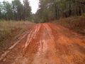
Now would be the time to mention that we have had a substantial amount of rain here in Georgia over the past few days. The road, at least at first, seemed to be easily passable. It is a single-lane gravel road. Once I got further down the road I noticed several places where there were very muddy spots. I became concerned that my little car would get stuck.
I got within about a kilometer of the hash with the car. I came upon a muddy spot on a slight rise that I didn't want to risk. This was a classic Georgia hazzard. The mud is Georgia red clay (slippery as grease, and messy). Walked about 700m up the road while trying to avoid the mud.
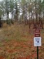
I turned south from the road. It was down hill from the road to the hash. The heavily wooded area was quite nice with little underbrush. I thought this would be easy. As it turned out the hash was located near the bottom of the ravine (ie, a swamp).
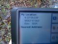
I danced the GPS around for about 15 minutes and found out how frustrating technology can be. My GPS is a cheap automobile unit. The refresh on the location is slow and jumpy. The whole dance was in water over the tops of my shoes.
I took some pictures of the site including the GPS readout, a shot of the hill that I would climb to leave, and a Stupid Grin photo. Found a carnivore skull in the ground cover near the hash. The area was quite beautiful and quiet. I did get a scare when I heard a loud crash nearby (deer? bear? raptor?). I figured I did as well as could be expected for my first time out so I slogged my way back to the car. I left behind a small tag attached to a tree as the only impact of my visit. The trip home was fine except for the wet feet. Round trip travel about 140 miles, 3.5 hours.
Photos
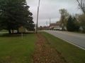
Mansfield, GA - a lovely little town.
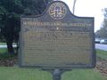
Historical marker in Mansfield, GA.
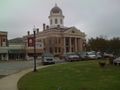
Jasper County courthouse (famous from movie My Cousin Vinnie, 1992)
I didn't attempt this.
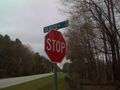
Nearest intersection (5k from hash).
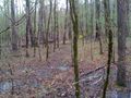
The target area.
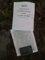
Laid my marker on a log in the swamp.
Hard to do solo, standing in swamp.

My first Stupid Grin photo. Note swamp.
Piedmont National Wildlife Refuge marker.


Achievements
tomkf61 earned the Land geohash achievement
|