Difference between revisions of "2011-04-01 34 -83"
From Geohashing
imported>Tomkf61 |
imported>Tomkf61 (→Plans) |
||
| Line 29: | Line 29: | ||
<!-- what were the original plans --> | <!-- what were the original plans --> | ||
| + | I immediately liked the look of this hash. It's located on the highway right-of-way so I don't expect any access issues. The area surrounding has a few places I'd like to visit. The Georgia mountains are one of my favorite places, ever. | ||
| − | + | Head out from home around 11:00 AM. Travel up Interstate 85 and go to Toccoa, GA from the south. Enjoy the drive. | |
| − | |||
| − | |||
| − | |||
== Expedition == | == Expedition == | ||
Revision as of 04:32, 2 April 2011
| Fri 1 Apr 2011 in 34,-83: 34.5523773, -83.3726063 geohashing.info google osm bing/os kml crox |
Location
On north side of Highway 17 (Toccoa Bypass), 4.75 kilometers from Toccoa, GA.
Participants
Plans
I immediately liked the look of this hash. It's located on the highway right-of-way so I don't expect any access issues. The area surrounding has a few places I'd like to visit. The Georgia mountains are one of my favorite places, ever.
Head out from home around 11:00 AM. Travel up Interstate 85 and go to Toccoa, GA from the south. Enjoy the drive.
Expedition
Will update soon.
Photos
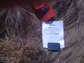
Hash 2011-04-01 34 -83.
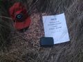
Hash 2011-04-01 34 -83.
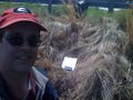
Stupid Grin.
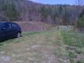
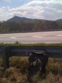
Where I parked.
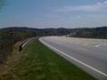
View down Hwy 17.
View of Currahee Mountain. (South)
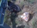
GeoTrash cleanup.
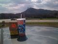
GeoSquishy (Currahee Mtn in distance).

Stephens Co., GA Courthouse.
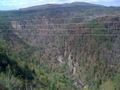
View of Tallulah Gorge.


Achievements
tomkf61 earned the Land geohash achievement
|
tomkf61 earned the GeoTrash Geohash Achievement
|