Difference between revisions of "2011-04-01 34 -83"
imported>Tomkf61 (→Plans) |
imported>Tomkf61 (→Expedition) |
||
| Line 36: | Line 36: | ||
<!-- how it all turned out. your narrative goes here. --> | <!-- how it all turned out. your narrative goes here. --> | ||
| − | + | Got a late start at 11:30. Missed turn lane for I-85 N at GA 20, darn. Decided that this was meant to be when I realized that I could get to Toccoa more easily on I-985. I particularly like this stretch of highway. I used to drive this way to visit my dad in Blairsville, GA. The drive was scenic and smooth all the way to the hash. | |
| − | |||
| − | |||
| − | |||
| − | |||
| − | |||
| − | |||
| − | |||
| − | |||
| − | |||
| − | |||
| − | |||
| − | |||
| − | |||
| − | |||
| − | |||
| + | My map survey shows the hash to be between to small access roads running north from Highway 17. I was somewhat concerned that the embankment on the north side of the highway would be too steep to access the hash. | ||
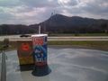
| + | I traveled down Highway 17 from the west and felt lucky that there was a median cut-through right where I needed it at the western access road just before the hash. I was able to turn left onto the access road. Parked the car so that I didn't block the road even though it seemed disused (see picture). | ||
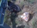
| + | Was able to walk straight to the hash along the road about 149 meters, then turned left for a couple of meters to the spot. The road embankment was in fact quite steep and overgrown with weeds, etc. Luckily, the hash was quite close to the top of the embankment. Danced the GPS around until I was on the hash. I really need a better GPS for this. Took pictures, marked the hash with a pile of bird seed that I brought. | ||
== Photos == | == Photos == | ||
Revision as of 04:57, 2 April 2011
| Fri 1 Apr 2011 in 34,-83: 34.5523773, -83.3726063 geohashing.info google osm bing/os kml crox |
Location
On north side of Highway 17 (Toccoa Bypass), 4.75 kilometers from Toccoa, GA.
Participants
Plans
I immediately liked the look of this hash. It's located on the highway right-of-way so I don't expect any access issues. The area surrounding has a few places I'd like to visit. The Georgia mountains are one of my favorite places, ever.
Head out from home around 11:00 AM. Travel up Interstate 85 and go to Toccoa, GA from the south. Enjoy the drive.
Expedition
Got a late start at 11:30. Missed turn lane for I-85 N at GA 20, darn. Decided that this was meant to be when I realized that I could get to Toccoa more easily on I-985. I particularly like this stretch of highway. I used to drive this way to visit my dad in Blairsville, GA. The drive was scenic and smooth all the way to the hash.
My map survey shows the hash to be between to small access roads running north from Highway 17. I was somewhat concerned that the embankment on the north side of the highway would be too steep to access the hash.
I traveled down Highway 17 from the west and felt lucky that there was a median cut-through right where I needed it at the western access road just before the hash. I was able to turn left onto the access road. Parked the car so that I didn't block the road even though it seemed disused (see picture).
Was able to walk straight to the hash along the road about 149 meters, then turned left for a couple of meters to the spot. The road embankment was in fact quite steep and overgrown with weeds, etc. Luckily, the hash was quite close to the top of the embankment. Danced the GPS around until I was on the hash. I really need a better GPS for this. Took pictures, marked the hash with a pile of bird seed that I brought.
Photos
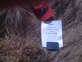
Hash 2011-04-01 34 -83.
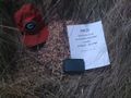
Hash 2011-04-01 34 -83.
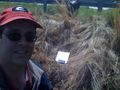
Stupid Grin.
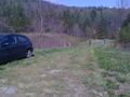
Where I parked.
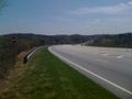
View down Hwy 17.
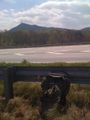
View of Currahee Mountain. (South)
GeoTrash cleanup.
GeoSquishy (Currahee Mtn in distance).

Stephens Co., GA Courthouse.
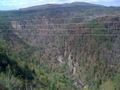
View of Tallulah Gorge.


Achievements
tomkf61 earned the Land geohash achievement
|
tomkf61 earned the GeoTrash Geohash Achievement
|