Difference between revisions of "2011-04-04 34 -86"
From Geohashing
imported>Jiml m (Expand template) |
imported>FippeBot m (Location) |
||
| (3 intermediate revisions by 2 users not shown) | |||
| Line 1: | Line 1: | ||
| − | |||
| − | |||
| − | |||
| − | |||
| − | |||
| − | |||
| − | |||
<!-- If you did not specify these parameters in the template, please substitute appropriate values for IMAGE, LAT, LON, and DATE (YYYY-MM-DD format) | <!-- If you did not specify these parameters in the template, please substitute appropriate values for IMAGE, LAT, LON, and DATE (YYYY-MM-DD format) | ||
| Line 18: | Line 11: | ||
| lat=34 | | lat=34 | ||
| lon=-86 | | lon=-86 | ||
| − | | date= | + | | date=2011-04-04 |
}} | }} | ||
| Line 25: | Line 18: | ||
== Location == | == Location == | ||
<!-- where you've surveyed the hash to be --> | <!-- where you've surveyed the hash to be --> | ||
| + | A street in Alabama | ||
== Participants == | == Participants == | ||
| − | + | * [[User:Yellowhammer|David]] | |
| + | * son Kyle | ||
== Plans == | == Plans == | ||
<!-- what were the original plans --> | <!-- what were the original plans --> | ||
| + | Unknown | ||
== Expedition == | == Expedition == | ||
| − | |||
| − | + | Kyle at the geohash point on April 4. We'd been planning to go to a point but just couldn't work it in because they had all been too far away to fit our schedule. But when the April 4 point in the Huntsville graticule popped up close to his school we took the opportunity. | |
| − | + | ||
| + | We'd tried to hit the April 3 point but got there after dark. There was no moon and all | ||
| + | we had were pen lights and cell phones to trek uphill through brush at night. We were | ||
| + | returning from a trip and had on street clothes - not prepared for a night trip through the woods. Discretion being the better part of valor, we went home. | ||
== Photos == | == Photos == | ||
| − | + | ||
| − | |||
| − | |||
<gallery perrow="5"> | <gallery perrow="5"> | ||
| + | Image:2011-04-04 14-39-52 461.jpg|Kyle at the hashpoint | ||
</gallery> | </gallery> | ||
| Line 48: | Line 45: | ||
{{#vardefine:ribbonwidth|800px}} | {{#vardefine:ribbonwidth|800px}} | ||
<!-- Add any achievement ribbons you earned below, or remove this section --> | <!-- Add any achievement ribbons you earned below, or remove this section --> | ||
| + | * Land geohash | ||
| − | |||
| − | |||
| − | |||
| − | + | [[Category:Expeditions]] | |
| − | |||
| − | [[Category: | ||
| − | |||
| − | |||
| − | |||
| − | |||
[[Category:Expeditions with photos]] | [[Category:Expeditions with photos]] | ||
| − | |||
| − | |||
| − | |||
| − | + | ||
[[Category:Coordinates reached]] | [[Category:Coordinates reached]] | ||
| − | + | {{location|US|AL|MD}} | |
| − | |||
| − | |||
| − | |||
| − | |||
| − | |||
| − | |||
| − | |||
| − | |||
| − | |||
Latest revision as of 03:56, 6 August 2019
| Mon 4 Apr 2011 in 34,-86: 34.8807687, -86.6241032 geohashing.info google osm bing/os kml crox |
Location
A street in Alabama
Participants
- David
- son Kyle
Plans
Unknown
Expedition
Kyle at the geohash point on April 4. We'd been planning to go to a point but just couldn't work it in because they had all been too far away to fit our schedule. But when the April 4 point in the Huntsville graticule popped up close to his school we took the opportunity.
We'd tried to hit the April 3 point but got there after dark. There was no moon and all we had were pen lights and cell phones to trek uphill through brush at night. We were returning from a trip and had on street clothes - not prepared for a night trip through the woods. Discretion being the better part of valor, we went home.
Photos
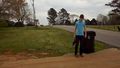
Kyle at the hashpoint

Achievements
- Land geohash