Difference between revisions of "2011-04-14 55 13"
From Geohashing
imported>Llavids (Created page with "{{meetup graticule | lat=55 | lon=13 | date=2011-04-14 }} __NOTOC__ == Location == Kyrkheddinge, Staffanstorp, Skåne, Sweden. == Par...") |
imported>Jiml m (Typo) |
||
| Line 10: | Line 10: | ||
== Participants == | == Participants == | ||
| − | * [[User:Llavids|Llavids]] Both of us! | + | * [[User:Llavids|Llavids]] - Both of us! |
== Plans == | == Plans == | ||
| Line 16: | Line 16: | ||
== Expedition == | == Expedition == | ||
| − | Tried to figure out whether to take the south or north bound trail along the creek. Decided on the | + | Tried to figure out whether to take the south or north bound trail along the creek. Decided on the south side, which was correct when reaching the geohash. Luckily the water was not too high and there was enough land to make it reachable without stepping into the creek. |
== Photos == | == Photos == | ||
Revision as of 01:56, 19 April 2011
| Thu 14 Apr 2011 in 55,13: 55.6581199, 13.2580997 geohashing.info google osm bing/os kml crox |
Location
Kyrkheddinge, Staffanstorp, Skåne, Sweden.
Participants
- Llavids - Both of us!
Plans
Location almost on our way home from work.
Expedition
Tried to figure out whether to take the south or north bound trail along the creek. Decided on the south side, which was correct when reaching the geohash. Luckily the water was not too high and there was enough land to make it reachable without stepping into the creek.
Photos
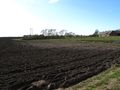
Over there

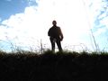
Proof
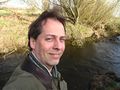
The grin
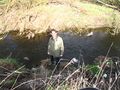
Positioned
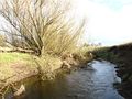
Looking north
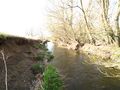
Looking south
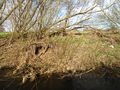
East, other side of creek
West, partner
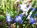
Flower all around
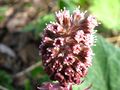
Flower all around
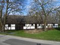
Nearest house


Achievements
Llavids earned the Land geohash achievement
|
Llavids earned the Consecutive geohash achievement
|