Difference between revisions of "2011-04-27 30 -89"
imported>Atreides ([live picture] This was his yard, which he graciously allowed us to trespass upon.) |
m (per Renaming Proposal) |
||
| (16 intermediate revisions by 6 users not shown) | |||
| Line 1: | Line 1: | ||
| − | |||
| − | |||
| − | |||
| − | |||
| − | |||
| − | |||
| − | |||
| − | |||
| − | |||
| − | |||
{{meetup graticule | {{meetup graticule | ||
| lat=30 | | lat=30 | ||
| Line 15: | Line 5: | ||
}} | }} | ||
| − | + | ||
__NOTOC__ | __NOTOC__ | ||
== Location == | == Location == | ||
| − | + | Near Anchor Lake, on the property line between two houses. | |
== Participants == | == Participants == | ||
| − | |||
| − | == | + | * [[User:Atreides|Atreides]] |
| − | + | * my nameless assistant. | |
| + | |||
| + | ==Expedition== | ||
| + | |||
| + | I was at school and checked the Geohash for today, and lo and behold, it was in my town! Easy trip for today, and work could be put off for such a noble endeavour. | ||
| + | |||
| + | I noted the location, and I would be embarking as soon as I possibly could. I printed out a fresh ambassador sheet, as it is easier to explain things to the people around here with written aids. Did I mention that it was only three miles from where I was? So close to a couch potato, but yet so far. I don't yet have a GPS, so we'd have to rely on the great Google maps and Geohash Droid for our accuracy, and that means no tracklog, so you'll have to trust me. This would be my first true geohash, I made one earlier, but it was for a different date, thereby nullifying it. We followed the coordinates through the roads, until they led us to two houses. | ||
| + | |||
| + | Both houses had many dogs, & I'm a little nervous about dogs. I pressed on, and upon approaching one of the houses, a wizened old man came out to greet us, & I kindly explained about the game and showed him the passport. He let us go, and we trekked the last 100 feet to the spot, where I took some photos, including the grin, but my accomplice would like to remain nameless for the time being. | ||
| − | + | I believe today would constitute an ambassador achievement. Now alas, I must get to work, and give my android a rest for now. Today truly was exciting! | |
| − | |||
| − | |||
| − | |||
== Photos == | == Photos == | ||
| − | + | ||
| − | |||
| − | |||
<gallery perrow="5"> | <gallery perrow="5"> | ||
Image:2011-04-27_30_-89_17-26-27-486.jpg | This was his yard, which he graciously allowed us to trespass upon. | Image:2011-04-27_30_-89_17-26-27-486.jpg | This was his yard, which he graciously allowed us to trespass upon. | ||
| + | |||
| + | Image:2011-04-27_30_-89_17-28-19-658.jpg | These are the coordinates and the mark showing we made it in case there is a discrepancy, I'm uploading these from a different location. | ||
| + | |||
| + | Image:2011-04-27_30_-89_17-29-52-060.jpg | The hole in which we decided the place would be within its accuracy. | ||
| + | |||
| + | Image:2011-04-27_30_-89_17-30-59-093.jpg | And of course, my grinning face at the scene of the crime. | ||
</gallery> | </gallery> | ||
== Achievements == | == Achievements == | ||
{{#vardefine:ribbonwidth|800px}} | {{#vardefine:ribbonwidth|800px}} | ||
| − | + | {{Land geohash | date=2011-04-27 |latitude = 30 |longitude = -89 | name = [[User:Atreides|Atreides]]}} | |
| + | {{Graticule unlocked | date=2011-04-27 |latitude = 30 |longitude = -89 | name = [[User:Atreides|Atreides]]}} | ||
| + | {{Ambassador geohash| date=2011-04-27 |latitude = 30 |longitude = -89 | name = [[User:Atreides|Atreides]]}} | ||
| − | + | [[Category:Expeditions]] | |
| − | |||
| − | [[Category: | ||
| − | + | [[Category:Expeditions with photos]] | |
| − | |||
| − | [[Category: | ||
| − | |||
| − | |||
| − | |||
| − | |||
| − | |||
| − | |||
| − | |||
| − | |||
| − | |||
| − | |||
[[Category:Coordinates reached]] | [[Category:Coordinates reached]] | ||
| − | + | {{location|US|MS|PL}} | |
| − | |||
| − | |||
| − | |||
| − | |||
| − | |||
| − | |||
| − | |||
| − | |||
| − | |||
Latest revision as of 05:55, 20 March 2024
| Wed 27 Apr 2011 in 30,-89: 30.6357710, -89.6078653 geohashing.info google osm bing/os kml crox |
Location
Near Anchor Lake, on the property line between two houses.
Participants
- Atreides
- my nameless assistant.
Expedition
I was at school and checked the Geohash for today, and lo and behold, it was in my town! Easy trip for today, and work could be put off for such a noble endeavour.
I noted the location, and I would be embarking as soon as I possibly could. I printed out a fresh ambassador sheet, as it is easier to explain things to the people around here with written aids. Did I mention that it was only three miles from where I was? So close to a couch potato, but yet so far. I don't yet have a GPS, so we'd have to rely on the great Google maps and Geohash Droid for our accuracy, and that means no tracklog, so you'll have to trust me. This would be my first true geohash, I made one earlier, but it was for a different date, thereby nullifying it. We followed the coordinates through the roads, until they led us to two houses.
Both houses had many dogs, & I'm a little nervous about dogs. I pressed on, and upon approaching one of the houses, a wizened old man came out to greet us, & I kindly explained about the game and showed him the passport. He let us go, and we trekked the last 100 feet to the spot, where I took some photos, including the grin, but my accomplice would like to remain nameless for the time being.
I believe today would constitute an ambassador achievement. Now alas, I must get to work, and give my android a rest for now. Today truly was exciting!
Photos
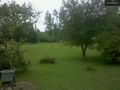
This was his yard, which he graciously allowed us to trespass upon.
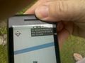
These are the coordinates and the mark showing we made it in case there is a discrepancy, I'm uploading these from a different location.
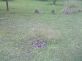
The hole in which we decided the place would be within its accuracy.

And of course, my grinning face at the scene of the crime.


Achievements
Atreides earned the Land geohash achievement
|
Atreides earned the Graticule Unlocked Achievement
|
Atreides earned the Ambassador achievement
|