Difference between revisions of "2011-04-27 40 -74"
imported>Jevanyn m (→Expedition) |
imported>FippeBot m (Location) |
||
| (4 intermediate revisions by one other user not shown) | |||
| Line 59: | Line 59: | ||
marker "XKCD 4-27-2011", but my phone's battery had not | marker "XKCD 4-27-2011", but my phone's battery had not | ||
enough charge to activate the built-in camera. | enough charge to activate the built-in camera. | ||
| − | |||
| − | |||
| − | |||
== Photos == | == Photos == | ||
| Line 69: | Line 66: | ||
<gallery perrow="5"> | <gallery perrow="5"> | ||
| − | Image:2011-04-27_40_-74_14-30-01-802.jpg | "Area preserved for recreation" | + | Image:2011-04-27_40_-74_14-30-01-802.jpg | "Area preserved for recreation" I think geohashing counts [http://www.openstreetmap.org/?lat=40.6358&lon=-74.6094&zoom=16&layers=B000FTF @40.6358,-74.6094] |
| − | Image:2011-04-27_40_-74_14- | + | Image:2011-04-27_40_-74_14-38-42-869.jpg | Camera not rotated, hill is really this steep [http://www.openstreetmap.org/?lat=40.6356&lon=-74.6092&zoom=16&layers=B000FTF @40.6356,-74.6092] |
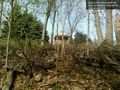
| − | Image:2011-04-27_40_-74_14- | + | Image:2011-04-27_40_-74_14-37-40-476.jpg | Skull of previous explorer. Gulp! [http://www.openstreetmap.org/?lat=40.6357&lon=-74.6091&zoom=16&layers=B000FTF @40.6357,-74.6091] |
| − | Image:2011-04-27_40_-74_14-34-08-453.jpg | Spotted a gazebo, | + | Image:2011-04-27_40_-74_14-34-08-453.jpg | Spotted a gazebo, I hope it doesn't attack [http://www.openstreetmap.org/?lat=40.6359&lon=-74.6077&zoom=16&layers=B000FTF @40.6359,-74.6077] |
| − | Image:2011-04-27_40_-74_14-35-15-148.jpg | | + | Image:2011-04-27_40_-74_14-35-15-148.jpg | View out over the treetops [http://www.openstreetmap.org/?lat=40.6359&lon=-74.6082&zoom=16&layers=B000FTF @40.6359,-74.6082] |
| − | Image:2011-04-27_40_-74_14-35-43-165.jpg | | + | Image:2011-04-27_40_-74_14-35-43-165.jpg | Receding hairline progressing nicely, thx4asking [http://www.openstreetmap.org/?lat=40.6359&lon=-74.6082&zoom=16&layers=B000FTF @40.6359,-74.6082] |
Image:2011-04-27_40_-74_14-36-50-655.jpg | Picture of the geohash (about 10 m ahead) [http://www.openstreetmap.org/?lat=40.6359&lon=-74.6077&zoom=16&layers=B000FTF @40.6359,-74.6077] | Image:2011-04-27_40_-74_14-36-50-655.jpg | Picture of the geohash (about 10 m ahead) [http://www.openstreetmap.org/?lat=40.6359&lon=-74.6077&zoom=16&layers=B000FTF @40.6359,-74.6077] | ||
| − | Image:2011-04-27_40_-74_14- | + | Image:2011-04-27_40_-74_14-33-07-708.jpg | Old tree stand, before tagging with "XKCD 4-27-2011" [http://www.openstreetmap.org/?lat=40.6361&lon=-74.6094&zoom=16&layers=B000FTF @40.6361,-74.6094] |
| + | |||
| + | Image:2011-04-27_40_-74_14-32-19-128.jpg | Trusty walking stick, found and left on-site [http://www.openstreetmap.org/?lat=40.6358&lon=-74.6094&zoom=16&layers=B000FTF @40.6358,-74.6094] | ||
| − | |||
</gallery> | </gallery> | ||
| Line 96: | Line 94: | ||
[[Category:Expeditions with photos]] | [[Category:Expeditions with photos]] | ||
[[Category:Coordinates reached]] | [[Category:Coordinates reached]] | ||
| + | {{location|US|NJ|SO}} | ||
Latest revision as of 06:17, 9 August 2019
| Wed 27 Apr 2011 in 40,-74: 40.6357710, -74.6078653 geohashing.info google osm bing/os kml crox |
Location
In the woods near "Second Watchung Mountain", between Donna Court and Timberline Drive, in Bridgewater, Somerset County.
Participants
Plans
Dude, it's in Bridgewater. It's less than ten miles from my house. I have all kinds of plans this afternoon, but I should be able to get there and back before dark, unless the weather turns nasty.
Expedition
The weather did get nasty: we got a downpour for about 20 minutes, enough to flash-flood a couple of local streets, But I was taking the highway except for the last mile so that didn't stop me.
I knew from the terrain map that I should expect a serious gradient, and it sure had one. Easily a 30 degree incline, by the time I was 50 feet from the car, I was 20-25 feet up, facing a near-vertical ridge. The ground was slippery with the recent rain, but a fallen branch made for a decent walking stick, and gave me the extra purchase to top the ledge.
I stopped for breath and checked the GPS. I wasn't much closer, but the goal was more to the east, across the face of the hill, which made for much easier climbing.
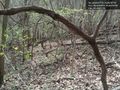
I went about 200 feet east and found a relatively clear route up (north), still pretty steep but with less brambles. On this leg, I also found an animal skull, about 6 inches long. Too small for a deer, too big for a squirrel. I took photos to show to others later.
I tacked north again, near the top of the hill, and stopped in view of the houses on the next street. Checking the GPS again, I had passed above the geohash; it was now southwest, about 90 feet away. You've heard of the GPS dance? Now picture someone doing it on the side of a 45 degree slope. That was me. The droid app put me within the circular margin for error, so I stopped again, this time for victory pictures.
On the way down, I was much further west than the climb up, and ended up within 20 feet or so of the cleared right-of-way where the powerlines were. I didn't take that path down the rest of the way, though, because I expected it to come to be fenced off. I angled a bit back to the east, and found a wooden platform, no doubt erected for the amusement of neighborhood kids of many years ago. One timber now bears the marker "XKCD 4-27-2011", but my phone's battery had not enough charge to activate the built-in camera.
Photos
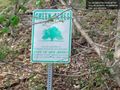
"Area preserved for recreation" I think geohashing counts @40.6358,-74.6094
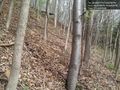
Camera not rotated, hill is really this steep @40.6356,-74.6092

Skull of previous explorer. Gulp! @40.6357,-74.6091
Spotted a gazebo, I hope it doesn't attack @40.6359,-74.6077
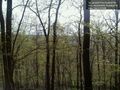
View out over the treetops @40.6359,-74.6082

Receding hairline progressing nicely, thx4asking @40.6359,-74.6082
Picture of the geohash (about 10 m ahead) @40.6359,-74.6077
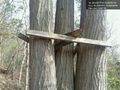
Old tree stand, before tagging with "XKCD 4-27-2011" @40.6361,-74.6094
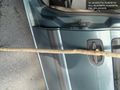
Trusty walking stick, found and left on-site @40.6358,-74.6094


