Difference between revisions of "2011-04-30 50 7"
imported>Hijackal m (possible participant: me) |
imported>FippeBot m (Location) |
||
| (16 intermediate revisions by 3 users not shown) | |||
| Line 1: | Line 1: | ||
| − | |||
| − | |||
| − | |||
| − | |||
| − | |||
| − | |||
| − | |||
| − | |||
| − | |||
{{meetup graticule | {{meetup graticule | ||
| lat=50 | | lat=50 | ||
| Line 20: | Line 11: | ||
== Participants == | == Participants == | ||
| − | [[User:Hijackal|Hijackal]] | + | * [[User:Hijackal|Hijackal]] and [[User:Frizzy|Frizzy]] |
| + | * [[User:Mampfred|Mampfred]] and [[User:LadyBB|LadyBB]] + 1 | ||
== Plans == | == Plans == | ||
[[User:Hijackal|Hijackal]] hopes to be able to convince a friend to come along. Possibly taking the train to Witterschlick, should be about an hours hike from there. | [[User:Hijackal|Hijackal]] hopes to be able to convince a friend to come along. Possibly taking the train to Witterschlick, should be about an hours hike from there. | ||
| + | |||
| + | [[User:Mampfred|Mampfred]] and [[User:LadyBB|LadyBB]] are thinking about this one as well after a bit of absence. Will probably be there late in the afternoon, give me a shout if that's not to late to meet up (possible in form of a private message with your mobile number ;). | ||
== Expedition == | == Expedition == | ||
| − | + | ===Hijackal and Frizzy=== | |
| + | Having found [[2011-04-16 50 6|his first hash]] exactly two weeks ago, Hijackal was happy to find that this Saturday's | ||
| + | hash was within walking distance of home. Since Hijackal and Frizzy were planning a short hike anyways, it was easy to convince Frizzy to chose the hash as a destination. Just before they were about to leave for the hash, Hijackal read Mampfred's note. Trying not to be at the hash too early, a longer route was chosen. The first minutes led the hashers in a direction they had never walked before, through blocks of rather ugly high-rise buildings. Amazingly, the rest of the way very pleasant, with a lovely forest starting just behind them. | ||
| + | |||
| + | The road north of the hash which had looked so promising on Google was blocked (twice), so they had to find alternatives. OSM users know more, so the handheld map showed a trail in the forest passing just southeast of the hash. Unfortunately, it also showed a blue line separating it from the hash. Although the first steps along the (rather tiny) stream had some rather steep banks, there was a tiny path leading down to the stream just opposite the hash. Even more amazingly, it continued on the other side, leading up to the field exactly where it was needed. | ||
| + | |||
| + | After some nettles, the hash was finally found in some high but nettle-free grass. The successful hashers waited for some time, until they found it was getting late to be back in town for dinner. So, Hijackal and Frizzy skipped the tron achievement for now and went back the way they came. | ||
| + | |||
| + | === Mampfred and LadyBB === | ||
| + | We got there a little later than expected, around 5:30pm. We had a quick look at the path leading to the hash according to Google but the gate was closed (twice) and we decided to try to go around (that's were we saw the sheeps though). Into the woods we went, we could see a little stream going along the fields and it looked entirely possible to get there if the hash turns out be outside the fence. At that point we saw two people coming out of the woods and one of them asked us what we were looking for. | ||
| + | |||
| + | "The hash" [[User:Mampfred|Mampfred]] replied and it turned out that [[User:Hijackal|Hijackal]] and his dragalong had stayed at the hash for quite a while in case we made it in time, thanks guys :) | ||
| + | |||
| + | They even were nice enough to show us the route they had taken earlier and so it was a walk in the park (and a stream to cross) to get there. Had a nice little chat and went back to the car together before saying goodbye. Nice meeting you guys, we're at our final destination now having a barbecue in the setting sun, until next time ... | ||
== Tracklog == | == Tracklog == | ||
| − | + | === Mampfred and LadyBB=== | |
| + | See [http://www.everytrail.com/view_trip.php?trip_id=1067235 here]. | ||
== Photos == | == Photos == | ||
| − | + | === Mampfred and LadyBB=== | |
| − | |||
| − | |||
<gallery perrow="5"> | <gallery perrow="5"> | ||
| + | Image:2011-04-30_50_7_fence2.jpg | Hmm, that qualifies as a gate, do not enter ... | ||
| + | Image:2011-04-30_50_7_fence.jpg | ... even two "gates", note the line behind it (sheep to the right). Not good. | ||
| + | Image:2011-04-30_50_7_16_sheep.jpg | Who needs 12 monkeys when he has 16 sheep? | ||
| + | Image:2011-04-30_50_7_sheep_close.jpg | Sheep closeup | ||
| + | Image:2011-04-30_50_7_hash_far.jpg | Look at the hash from the road | ||
| + | Image:2011-04-30_50_7_nature_park.jpg | Nature park "Kottenforst-Ville". Right. | ||
| + | Image:2011-04-30_50_7_stream.jpg | Stream! | ||
| + | Image:2011-04-30_50_7_jump.jpg | Jump! | ||
| + | Image:2011-04-30_50_7_coordinates.jpg| Coordinates ... | ||
| + | Image:2011-04-30_50_7_reached.jpg | ... reached. | ||
| + | Image:2011-04-30_50_7_the_hash.jpg | The hash. | ||
| + | Image:2011-04-30_50_7_hashtalk.jpg | Hash-Talk (tm) | ||
| + | Image:2011-04-30_50_7_grassy.jpg | Grassy hash it is. | ||
| + | </gallery> | ||
| + | |||
| + | === Hijackal === | ||
| + | <gallery perrow="5"> | ||
| + | Image:2011-04-30_50_7_screenshot.png | Got it! | ||
| + | Image:2011-04-30_50_7_snail.png | A very tiny snail we met at the hash | ||
| + | Image:2011-04-30_50_7_wet_obstacle.png | The last obstacle on the way to the hash... | ||
| + | Image:2011-04-30_50_7_not_so_wet.png | ...wasn't as difficult to cross as it first seemed. | ||
| + | Image:2011-04-30_50_7_four_grins.png | Four happy hashers | ||
</gallery> | </gallery> | ||
== Achievements == | == Achievements == | ||
{{#vardefine:ribbonwidth|800px}} | {{#vardefine:ribbonwidth|800px}} | ||
| − | + | {{Land geohash | |
| + | | latitude = 50 | ||
| + | | longitude = 7 | ||
| + | | date = 2011-04-30 | ||
| + | | name = [[User:Hijackal|Hijackal]], [[User:Mampfred|Mampfred]], [[User:LadyBB|LadyBB]] (+1) and [[User:Frizzy|Frizzy]] | ||
| + | }} | ||
| + | {{drag-along | ||
| + | | latitude=50 | ||
| + | | longitude=7 | ||
| + | | date=2011-04-30 | ||
| + | | name=[[User:Hijackal|Hijackal]] | ||
| + | | partner=[[User:Frizzy|Frizzy]] | ||
| + | }} | ||
| + | {{Walk geohash | ||
| + | | latitude = 50 | ||
| + | | longitude = 7 | ||
| + | | date = 2011-04-30 | ||
| + | | name = [[User:Hijackal|Hijackal]] and [[User:Frizzy|Frizzy]] | ||
| + | | distance = 15 km | ||
| + | }} | ||
| + | {{Meet-up | ||
| + | | latitude = 50 | ||
| + | | longitude = 7 | ||
| + | | date = 2011-04-30 | ||
| + | | name = [[User:Hijackal|Hijackal]] and [[User:Frizzy|Frizzy]] | ||
| + | | other = [[User:Mampfred|Mampfred]] and [[User:LadyBB|LadyBB]] (+1) | ||
| + | | image = 2011-04-30_50_7_four_grins.png | ||
| + | }} | ||
| − | |||
| − | |||
| − | |||
| − | |||
| − | |||
| − | |||
| − | |||
| − | |||
| − | |||
| − | |||
| − | |||
[[Category:Expeditions]] | [[Category:Expeditions]] | ||
| − | |||
[[Category:Expeditions with photos]] | [[Category:Expeditions with photos]] | ||
| − | |||
| − | |||
| − | |||
| − | |||
| − | |||
[[Category:Coordinates reached]] | [[Category:Coordinates reached]] | ||
| − | + | {{location|DE|NW|BN}} | |
| − | |||
| − | |||
| − | |||
| − | |||
| − | |||
| − | |||
| − | |||
| − | |||
| − | |||
Latest revision as of 06:20, 9 August 2019
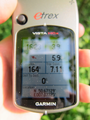
| Sat 30 Apr 2011 in 50,7: 50.6712943, 7.0772488 geohashing.info google osm bing/os kml crox |
Location
On a field near Röttgen. Looks like it might be fenced, though.
Participants
Plans
Hijackal hopes to be able to convince a friend to come along. Possibly taking the train to Witterschlick, should be about an hours hike from there.
Mampfred and LadyBB are thinking about this one as well after a bit of absence. Will probably be there late in the afternoon, give me a shout if that's not to late to meet up (possible in form of a private message with your mobile number ;).
Expedition
Hijackal and Frizzy
Having found his first hash exactly two weeks ago, Hijackal was happy to find that this Saturday's hash was within walking distance of home. Since Hijackal and Frizzy were planning a short hike anyways, it was easy to convince Frizzy to chose the hash as a destination. Just before they were about to leave for the hash, Hijackal read Mampfred's note. Trying not to be at the hash too early, a longer route was chosen. The first minutes led the hashers in a direction they had never walked before, through blocks of rather ugly high-rise buildings. Amazingly, the rest of the way very pleasant, with a lovely forest starting just behind them.
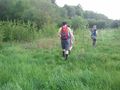
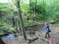
The road north of the hash which had looked so promising on Google was blocked (twice), so they had to find alternatives. OSM users know more, so the handheld map showed a trail in the forest passing just southeast of the hash. Unfortunately, it also showed a blue line separating it from the hash. Although the first steps along the (rather tiny) stream had some rather steep banks, there was a tiny path leading down to the stream just opposite the hash. Even more amazingly, it continued on the other side, leading up to the field exactly where it was needed.
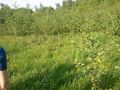
After some nettles, the hash was finally found in some high but nettle-free grass. The successful hashers waited for some time, until they found it was getting late to be back in town for dinner. So, Hijackal and Frizzy skipped the tron achievement for now and went back the way they came.
Mampfred and LadyBB
We got there a little later than expected, around 5:30pm. We had a quick look at the path leading to the hash according to Google but the gate was closed (twice) and we decided to try to go around (that's were we saw the sheeps though). Into the woods we went, we could see a little stream going along the fields and it looked entirely possible to get there if the hash turns out be outside the fence. At that point we saw two people coming out of the woods and one of them asked us what we were looking for.
"The hash" Mampfred replied and it turned out that Hijackal and his dragalong had stayed at the hash for quite a while in case we made it in time, thanks guys :)
They even were nice enough to show us the route they had taken earlier and so it was a walk in the park (and a stream to cross) to get there. Had a nice little chat and went back to the car together before saying goodbye. Nice meeting you guys, we're at our final destination now having a barbecue in the setting sun, until next time ...
Tracklog
Mampfred and LadyBB
See here.
Photos
Mampfred and LadyBB
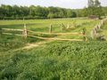
Hmm, that qualifies as a gate, do not enter ...
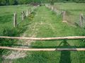
... even two "gates", note the line behind it (sheep to the right). Not good.
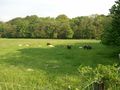
Who needs 12 monkeys when he has 16 sheep?
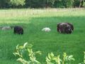
Sheep closeup
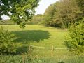
Look at the hash from the road
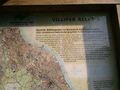
Nature park "Kottenforst-Ville". Right.
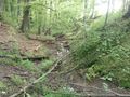
Stream!
Jump!
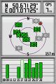
Coordinates ...

... reached.
The hash.
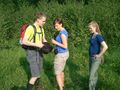
Hash-Talk (tm)
Grassy hash it is.


Hijackal
Got it!

A very tiny snail we met at the hash
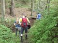
The last obstacle on the way to the hash...
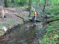
...wasn't as difficult to cross as it first seemed.

Four happy hashers


Achievements
Hijackal, Mampfred, LadyBB (+1) and Frizzy earned the Land geohash achievement
|
Hijackal earned the Drag-along achievement
|
Hijackal and Frizzy earned the Walk geohash Achievement
|
Hijackal and Frizzy earned the Meet-up achievement
|