Difference between revisions of "2011-05-04 48 7"
imported>Hijackal (might ride there after work) |
m |
||
| (3 intermediate revisions by 2 users not shown) | |||
| Line 1: | Line 1: | ||
| − | |||
<!-- If you did not specify these parameters in the template, please substitute appropriate values for IMAGE, LAT, LON, and DATE (YYYY-MM-DD format) | <!-- If you did not specify these parameters in the template, please substitute appropriate values for IMAGE, LAT, LON, and DATE (YYYY-MM-DD format) | ||
| Line 18: | Line 17: | ||
__NOTOC__ | __NOTOC__ | ||
== Location == | == Location == | ||
| − | + | Near Bötzingen, 10 km to the northwest of Freiburg. The hash appears to be on a field, some 20 m from the nearest road. | |
== Participants == | == Participants == | ||
| − | + | [[User:Hijackal|Hijackal]] | |
== Plans == | == Plans == | ||
| − | + | [[User:Hijackal|Hijackal]] happens to be in Freiburg, with his bike (badly needing repair). Depending on how much work there is today, he hopes to get there in the evening. | |
== Expedition == | == Expedition == | ||
| − | + | There was no work left for the day with still plenty of daylight to go, so Hijackal cycled to the hash. The first half of the trip was easy riding along the Dreisam. Then, Hijackal learned that just because something is a field does not mean it has to be flat. Of course, he could have known: there's lots of wine from around here, and vineyards can be pretty steep. | |
| + | |||
| + | The hash itself was in an actual vineyard, not really accessible from the road, but not fenced in either. Hijackal asked the lady just leaving the vineyard for permission to enter the vines; she didn't really seem to care about what I wanted to do there - she just commented that I should have come earlier to help her, as she was just leaving from a day's work in the vineyard. If noone had been there, Hijackal would have probably entered the vineyard anyways, so no [[Ambassador]] achievement for now... | ||
| − | + | On the way back, Hijackal took a slightly different path, going for the [[Tron]], but forgot that he had taken a wrong turn on the way to the hash, so he hit his imaginary Tron wall at 30 km/h, luckily without any real damage... | |
| − | |||
== Photos == | == Photos == | ||
| Line 37: | Line 37: | ||
--> | --> | ||
<gallery perrow="5"> | <gallery perrow="5"> | ||
| + | Image:2011-05-04_48_7_GPS.PNG | Yay! | ||
| + | Image:2011-05-04_48_7_no_grin.PNG | Sorry, forgot the [[stupid grin]]. Still practicing... | ||
| + | Image:2011-05-04_48_7_bike.PNG | Nice countryside, hashbike | ||
</gallery> | </gallery> | ||
== Achievements == | == Achievements == | ||
{{#vardefine:ribbonwidth|800px}} | {{#vardefine:ribbonwidth|800px}} | ||
| − | + | {{land geohash | latitude = 48 | longitude = 7 | date = 2011-05-04 | name = [[User:Hijackal|Hijackal]] }} | |
| − | |||
| − | + | {{Bicycle geohash | latitude = 48 | longitude = 7 | date = 2011-05-04 | name = [[User:Hijackal|Hijackal]] | distance = 28,4 km }} | |
| − | |||
| − | [[ | ||
| − | |||
| − | |||
| − | |||
| − | |||
| − | |||
[[Category:Expeditions]] | [[Category:Expeditions]] | ||
| − | |||
[[Category:Expeditions with photos]] | [[Category:Expeditions with photos]] | ||
| − | |||
| − | |||
| − | |||
| − | |||
| − | |||
[[Category:Coordinates reached]] | [[Category:Coordinates reached]] | ||
| − | + | {{location|DE|BW|FR}} | |
| − | |||
| − | |||
| − | |||
| − | |||
| − | |||
| − | |||
| − | |||
| − | |||
| − | |||
Latest revision as of 21:53, 4 March 2020
| Wed 4 May 2011 in 48,7: 48.0829395, 7.7099366 geohashing.info google osm bing/os kml crox |
Location
Near Bötzingen, 10 km to the northwest of Freiburg. The hash appears to be on a field, some 20 m from the nearest road.
Participants
Plans
Hijackal happens to be in Freiburg, with his bike (badly needing repair). Depending on how much work there is today, he hopes to get there in the evening.
Expedition
There was no work left for the day with still plenty of daylight to go, so Hijackal cycled to the hash. The first half of the trip was easy riding along the Dreisam. Then, Hijackal learned that just because something is a field does not mean it has to be flat. Of course, he could have known: there's lots of wine from around here, and vineyards can be pretty steep.
The hash itself was in an actual vineyard, not really accessible from the road, but not fenced in either. Hijackal asked the lady just leaving the vineyard for permission to enter the vines; she didn't really seem to care about what I wanted to do there - she just commented that I should have come earlier to help her, as she was just leaving from a day's work in the vineyard. If noone had been there, Hijackal would have probably entered the vineyard anyways, so no Ambassador achievement for now...
On the way back, Hijackal took a slightly different path, going for the Tron, but forgot that he had taken a wrong turn on the way to the hash, so he hit his imaginary Tron wall at 30 km/h, luckily without any real damage...
Photos
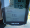
Yay!
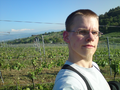
Sorry, forgot the stupid grin. Still practicing...
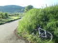
Nice countryside, hashbike


Achievements
Hijackal earned the Land geohash achievement
|
Hijackal earned the Bicycle geohash achievement
|