Difference between revisions of "2011-05-07 50 7"
imported>Mampfred (success, more later ... or rather earlier tomorrow) |
imported>Mampfred |
||
| Line 7: | Line 7: | ||
__NOTOC__ | __NOTOC__ | ||
== Location == | == Location == | ||
| − | In the woods near Höhr. | + | In the woods near Höhr-Grenzhausen. |
== Participants == | == Participants == | ||
*[[User:Mampfred|Mampfred]] | *[[User:Mampfred|Mampfred]] | ||
| − | *[[User:QuarterCacher|QuarterCacher]] | + | *[[User:QuarterCacher|QuarterCacher]] |
== Plans == | == Plans == | ||
| Line 17: | Line 17: | ||
== Expedition == | == Expedition == | ||
| − | + | We met at [[User:QuarterCacher|QuarterCacher]]s place at 9pm and headed out for the first hash of the night. Drive was pretty straight forward, google maps was a good preparation for what was to come. We chose the slightly longer track towards the hash as it would bring us closer to it with less risk of tracks not being there (don't ask happens alll the time if you have the open street map maps on your GPS). | |
| + | |||
| + | The hash was 10 meters of the track into some thorny bushes - ouch. Anyway, that was around 10:10pm, we snapped a stupid grin photo with a little moon light and headed back to the care and our second [[2011-05-08 50 7|destination]] for the night. | ||
| + | |||
| + | 2.8km walking, nice start. | ||
== Tracklog == | == Tracklog == | ||
| − | + | ===Mampfred=== | |
| + | See [http://www.everytrail.com/view_trip.php?trip_id=1080922 here]. | ||
== Photos == | == Photos == | ||
| − | + | ([[User:QuarterCacher|QuarterCacher]] took the good ones, it usually takes a while to get these online ;) | |
| − | + | ===Mampfred=== | |
| − | |||
<gallery perrow="5"> | <gallery perrow="5"> | ||
| + | Image:2011-05-07_50_7_coordinates.jpg | Coordinates ... | ||
| + | Image:2011-05-07_50_7_reached.jpg | ... reached. | ||
</gallery> | </gallery> | ||
== Achievements == | == Achievements == | ||
{{#vardefine:ribbonwidth|800px}} | {{#vardefine:ribbonwidth|800px}} | ||
| + | {{Land geohash | ||
| + | | latitude = 50 | ||
| + | | longitude = 7 | ||
| + | | date = 2011-05-07 | ||
| + | | name = [[User:QuarterCacher|QuarterCacher]] and [[User:Mampfred|Mampfred]] | ||
| + | }} | ||
[[Category:Expeditions]] | [[Category:Expeditions]] | ||
[[Category:Expeditions with photos]] | [[Category:Expeditions with photos]] | ||
[[Category:Coordinates reached]] | [[Category:Coordinates reached]] | ||
Revision as of 10:07, 8 May 2011
| Sat 7 May 2011 in 50,7: 50.4425543, 7.6903141 geohashing.info google osm bing/os kml crox |
Location
In the woods near Höhr-Grenzhausen.
Participants
Plans
Go there late in the evening, when done, head on to 2011-05-08 50 7 ...
Expedition
We met at QuarterCachers place at 9pm and headed out for the first hash of the night. Drive was pretty straight forward, google maps was a good preparation for what was to come. We chose the slightly longer track towards the hash as it would bring us closer to it with less risk of tracks not being there (don't ask happens alll the time if you have the open street map maps on your GPS).
The hash was 10 meters of the track into some thorny bushes - ouch. Anyway, that was around 10:10pm, we snapped a stupid grin photo with a little moon light and headed back to the care and our second destination for the night.
2.8km walking, nice start.
Tracklog
Mampfred
See here.
Photos
(QuarterCacher took the good ones, it usually takes a while to get these online ;)
Mampfred
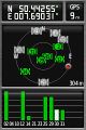
Coordinates ...
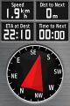
... reached.


Achievements
QuarterCacher and Mampfred earned the Land geohash achievement
|