Difference between revisions of "2011-05-10 53 10"
imported>Bierhefe (→Location) |
imported>FippeBot m (Location) |
||
| (14 intermediate revisions by 3 users not shown) | |||
| Line 1: | Line 1: | ||
| + | [[Image:{{{Marker in the Saxony Forest|53_10_2011-05-10_06.JPG}}}|thumb|left]] | ||
| − | |||
| − | |||
| − | |||
| − | |||
| − | |||
| − | |||
| − | |||
| − | |||
| − | |||
{{meetup graticule | {{meetup graticule | ||
| lat=53 | | lat=53 | ||
| Line 15: | Line 7: | ||
}} | }} | ||
| − | + | ||
__NOTOC__ | __NOTOC__ | ||
== Location == | == Location == | ||
| − | + | ||
In a forest between Kröppelshagen-Fahrendorf and Dassendorf. | In a forest between Kröppelshagen-Fahrendorf and Dassendorf. | ||
== Participants == | == Participants == | ||
<!-- who attended --> | <!-- who attended --> | ||
| + | [[User:Bierhefe|Bierhefe]], together with his wife | ||
== Plans == | == Plans == | ||
| − | + | ||
| + | [[User:Bierhefe|Bierhefe]] tries to reach this hash after work. Either by bike or by public transportation, depends on wether his wife joins him or not. | ||
== Expedition == | == Expedition == | ||
| − | + | ||
| + | When I got home from work I asked my wife if she wanted to go to todays geohash and she said yes. Since public transportation | ||
| + | is very limited in the suburbs of Hamburg and my wife's bike needs some serious repairing we decided to take the car to the hash. | ||
| + | The hashpoint is very easy to reach by car, so we made an exception to our "rule" of not going by car to a hashpoint. Also, | ||
| + | it was a good chance to finally get into the Sachsenwald (Saxony Forest). | ||
| + | |||
| + | After some packing we got going. After a very uneventful car ride (the only exciting thing was when we missed a turn and | ||
| + | had to turn around) we reached the forest. Some 400 meters later we got close to the hash point. | ||
| + | |||
| + | On our way here we saw a sign which said "stay on the paths!". But since we only had to go a few meters into the forest | ||
| + | we decided to go there. The connection of the GPS was surprisingly good and I think we got VERY close to the actual hash | ||
| + | point. At first I thought to leave my paper marker here, but since the aformentioned sign also said "No littering!" we | ||
| + | made our own XKCD sign out of some sticks. | ||
| + | |||
| + | After we got out of the forest, we went to a nearby geocache (but it wasn't close enough to claim the Hash collision achievement). | ||
| + | Then we had a small picinc on some cut down trees. We originally planned to have the picnic at the hash point, but since it was | ||
| + | located in the forest we decided the cut down trees were close enough to the point to claim the achievement. ;) | ||
== Tracklog == | == Tracklog == | ||
| − | + | Tracklog available [http://waka.bplaced.net/geohash/2011-05-10_53_10.gpx here] or on [http://de.everytrail.com/view_trip.php?trip_id=1101024 everytrail]. I started logging the track shortly after we missed the turn I mentioned in the expedition log. | |
== Photos == | == Photos == | ||
| − | |||
| − | |||
| − | |||
<gallery perrow="5"> | <gallery perrow="5"> | ||
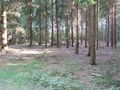
| + | Image:53_10_2011-05-10_01.JPG|The way to the hashpoint | ||
| + | Image:53_10_2011-05-10_02.JPG|A sign | ||
| + | Image:53_10_2011-05-10_03.JPG|Marker, Hashcots, Mobile, GPS | ||
| + | Image:53_10_2011-05-10_04.JPG|GPS, now readable | ||
| + | Image:53_10_2011-05-10_05.JPG|Stupid Grin<sup>tm</sup> | ||
| + | Image:53_10_2011-05-10_06.JPG|Sticks and no stones | ||
| + | Image:2011-05-10-07.JPG|Cut down trees | ||
| + | Image:53_10_2011-05-10_08.JPG|Place of the geocache | ||
| + | Image:53_10_2011-05-10_09.JPG|Picnic | ||
| + | Image:53_10_2011-05-10_11.JPG|The forester's house of Bornberg | ||
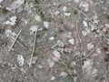
| + | Image:53_10_2011-05-10_13.JPG|There's a stone, but no stick | ||
</gallery> | </gallery> | ||
== Achievements == | == Achievements == | ||
{{#vardefine:ribbonwidth|800px}} | {{#vardefine:ribbonwidth|800px}} | ||
| − | |||
| + | {{land geohash | ||
| + | | latitude = 53 | ||
| + | | longitude = 10 | ||
| + | | date = 2011-05-10 | ||
| + | | name = [[User:Bierhefe|Bierhefe]] and his wife | ||
| + | }} | ||
| − | + | {{Radio Yerevan | |
| − | + | | achievement = [[Picnic achievement]] | |
| − | + | | detail = he didn't bring any of the required accoutrements | |
| + | | latitude = 53 | ||
| + | | longitude = 10 | ||
| + | | date = 2011-05-10 | ||
| + | | name = [[User:Bierhefe|Bierhefe]] and his wife | ||
| + | | food = Cucumber and pepper | ||
| + | }} | ||
| + | Oh c***! We even brought a blanket with us, but didn't use it. :(<br> | ||
| + | Ah well, lesson learned for the next time. ;) | ||
| − | |||
| − | |||
| − | |||
| − | |||
| − | |||
| − | |||
[[Category:Expeditions]] | [[Category:Expeditions]] | ||
| − | |||
[[Category:Expeditions with photos]] | [[Category:Expeditions with photos]] | ||
| − | |||
| − | |||
| − | |||
| − | |||
| − | |||
[[Category:Coordinates reached]] | [[Category:Coordinates reached]] | ||
| − | + | {{location|DE|SH|RZ}} | |
| − | |||
| − | |||
| − | |||
| − | |||
| − | |||
| − | |||
| − | |||
| − | |||
| − | |||
Latest revision as of 06:29, 9 August 2019

| Tue 10 May 2011 in 53,10: 53.4957903, 10.3347794 geohashing.info google osm bing/os kml crox |
Location
In a forest between Kröppelshagen-Fahrendorf and Dassendorf.
Participants
Bierhefe, together with his wife
Plans
Bierhefe tries to reach this hash after work. Either by bike or by public transportation, depends on wether his wife joins him or not.
Expedition
When I got home from work I asked my wife if she wanted to go to todays geohash and she said yes. Since public transportation is very limited in the suburbs of Hamburg and my wife's bike needs some serious repairing we decided to take the car to the hash. The hashpoint is very easy to reach by car, so we made an exception to our "rule" of not going by car to a hashpoint. Also, it was a good chance to finally get into the Sachsenwald (Saxony Forest).
After some packing we got going. After a very uneventful car ride (the only exciting thing was when we missed a turn and had to turn around) we reached the forest. Some 400 meters later we got close to the hash point.
On our way here we saw a sign which said "stay on the paths!". But since we only had to go a few meters into the forest we decided to go there. The connection of the GPS was surprisingly good and I think we got VERY close to the actual hash point. At first I thought to leave my paper marker here, but since the aformentioned sign also said "No littering!" we made our own XKCD sign out of some sticks.
After we got out of the forest, we went to a nearby geocache (but it wasn't close enough to claim the Hash collision achievement). Then we had a small picinc on some cut down trees. We originally planned to have the picnic at the hash point, but since it was located in the forest we decided the cut down trees were close enough to the point to claim the achievement. ;)
Tracklog
Tracklog available here or on everytrail. I started logging the track shortly after we missed the turn I mentioned in the expedition log.
Photos
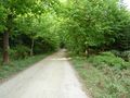
The way to the hashpoint
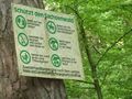
A sign
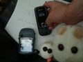
Marker, Hashcots, Mobile, GPS
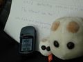
GPS, now readable
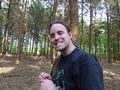
Stupid Grintm
Sticks and no stones
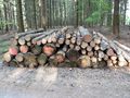
Cut down trees
Place of the geocache
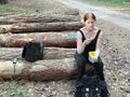
Picnic
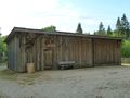
The forester's house of Bornberg
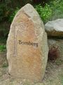
There's a stone, but no stick


Achievements
Bierhefe and his wife earned the Land geohash achievement
|
Is it true that this user earned the Picnic achievement?
|
Oh c***! We even brought a blanket with us, but didn't use it. :(
Ah well, lesson learned for the next time. ;)