Difference between revisions of "2011-05-17 50 7"
imported>Frizzy (subst better) |
imported>FippeBot m (Location) |
||
| (11 intermediate revisions by 3 users not shown) | |||
| Line 14: | Line 14: | ||
}} | }} | ||
| − | + | ||
__NOTOC__ | __NOTOC__ | ||
== Location == | == Location == | ||
| − | + | ||
| + | Mondorf, in a garden at Garden Street | ||
== Participants == | == Participants == | ||
| − | + | ||
| + | * [[User:Frizzy|Frizzy]] | ||
== Plans == | == Plans == | ||
| − | + | ||
| + | * [[User:Frizzy|Frizzy]]: Tomorrow evening I will take my bicycle and ride to Mondorf without GPS maybe, because the Hash will be in a garden in the "Gartenstraße". | ||
| + | |||
| + | I hope I'll find it and can take the ferry back to the right side of the Rhine... | ||
== Expedition == | == Expedition == | ||
| − | |||
| − | + | What a journey full of adventures. I started the tour with my bike at the Poppelsdorfer Schloss in Bonn. | |
| − | + | ||
| + | I decided to ride along the Rhine on the right side, but it was a mess...everywhere there was a lot of | ||
| + | building lots. And I was a bit confused with my GPS, so I had to make a phone call to make sure to find the right spot in Mondorf. Thank you Hijackal :) | ||
| + | |||
| + | Luckily the weather was quite nice and the next section of my journey was without any derailments. | ||
| + | |||
| + | It was easy to find the right house with the right garden, but I wasn't in a mood to ring the bell, so I decided to log the Geohash in front of the house. | ||
| + | |||
| + | From Mondorf to the other side of the Rhine I took the ferry and I enjoyed it very much! | ||
| + | |||
== Photos == | == Photos == | ||
| − | + | ||
| − | |||
| − | |||
<gallery perrow="5"> | <gallery perrow="5"> | ||
| + | Image:2011-05-17_50_7_gartenstraße.JPG | This is the street... | ||
| + | Image:2011-05-17_50_7_house.JPG | This is the house... | ||
| + | Image:2011-05-17_50_7_coordinates.JPG | Coordinates | ||
| + | Image:2011-05-17_50_7_track.JPG | Track | ||
| + | Image:2011-05-17_50_7_frizzy_bike.JPG | It's me and my bike :) | ||
| + | Image:2011-05-17_50_7_ferry.JPG | This is the ferry I took way back home. | ||
| + | Image:2011-05-17_50_7_bike_on_ferry.jpg.JPG | Look, here is my bike. | ||
| + | Image:2011-05-17_50_7_ticket.JPG | Ticket! | ||
| + | Image:2011-05-17_50_7_rhine.JPG | Lovely river :) | ||
</gallery> | </gallery> | ||
| Line 41: | Line 61: | ||
{{#vardefine:ribbonwidth|800px}} | {{#vardefine:ribbonwidth|800px}} | ||
<!-- Add any achievement ribbons you earned below, or remove this section --> | <!-- Add any achievement ribbons you earned below, or remove this section --> | ||
| + | |||
| + | {{Bicycle geohash | latitude = 50 | longitude = 7 | date = 2011-05-17 | name = [[User:Frizzy|Frizzy]] | distance = 20 km }} | ||
| − | |||
| − | |||
| − | |||
| − | |||
| − | |||
| − | |||
| − | |||
| − | |||
[[Category:Expeditions]] | [[Category:Expeditions]] | ||
| − | + | ||
[[Category:Expeditions with photos]] | [[Category:Expeditions with photos]] | ||
| − | + | ||
| − | |||
| − | |||
| − | |||
[[Category:Coordinates reached]] | [[Category:Coordinates reached]] | ||
| − | + | {{location|DE|NW|SU}} | |
| − | |||
| − | |||
| − | |||
| − | |||
| − | |||
| − | |||
| − | |||
| − | |||
| − | |||
Latest revision as of 06:34, 9 August 2019
| Tue 17 May 2011 in 50,7: 50.7784544, 7.0725171 geohashing.info google osm bing/os kml crox |
Location
Mondorf, in a garden at Garden Street
Participants
Plans
- Frizzy: Tomorrow evening I will take my bicycle and ride to Mondorf without GPS maybe, because the Hash will be in a garden in the "Gartenstraße".
I hope I'll find it and can take the ferry back to the right side of the Rhine...
Expedition
What a journey full of adventures. I started the tour with my bike at the Poppelsdorfer Schloss in Bonn.
I decided to ride along the Rhine on the right side, but it was a mess...everywhere there was a lot of building lots. And I was a bit confused with my GPS, so I had to make a phone call to make sure to find the right spot in Mondorf. Thank you Hijackal :)
Luckily the weather was quite nice and the next section of my journey was without any derailments.
It was easy to find the right house with the right garden, but I wasn't in a mood to ring the bell, so I decided to log the Geohash in front of the house.
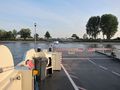
From Mondorf to the other side of the Rhine I took the ferry and I enjoyed it very much!
Photos
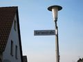
This is the street...
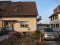
This is the house...
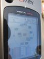
Coordinates
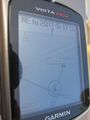
Track
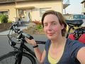
It's me and my bike :)
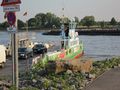
This is the ferry I took way back home.
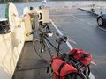
Look, here is my bike.
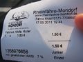
Ticket!
Lovely river :)


Achievements
Frizzy earned the Bicycle geohash achievement
|