Difference between revisions of "2011-05-21 40 -74"
imported>Jevanyn (→Tracklog) |
imported>FippeBot m (Location) |
||
| (4 intermediate revisions by one other user not shown) | |||
| Line 24: | Line 24: | ||
== Plans == | == Plans == | ||
:[[User:Jevanyn|Jevanyn]]: I've been in the area a hundred times, as 206 is my regular route to Cape May. I can't make it in the morning, but I'm going to make an effort to be there if there is a meetup. | :[[User:Jevanyn|Jevanyn]]: I've been in the area a hundred times, as 206 is my regular route to Cape May. I can't make it in the morning, but I'm going to make an effort to be there if there is a meetup. | ||
| − | |||
| − | |||
| − | |||
== Expedition == | == Expedition == | ||
| Line 40: | Line 37: | ||
*The GPS on my phone, without which I parked over a mile from the canal. | *The GPS on my phone, without which I parked over a mile from the canal. | ||
*Google Maps, which said there was a path or something on the east side of the canal, when there wasn't. | *Google Maps, which said there was a path or something on the east side of the canal, when there wasn't. | ||
| − | |||
*Walking uphill for a mile in the rain. | *Walking uphill for a mile in the rain. | ||
*Not getting a canoe when the geohash is spitting distance from a canal. Duh! | *Not getting a canoe when the geohash is spitting distance from a canal. Duh! | ||
| Line 66: | Line 62: | ||
Image:2011-05-21_40_-74_03-40-46-112.jpg | A geohasher | Image:2011-05-21_40_-74_03-40-46-112.jpg | A geohasher | ||
| − | Image:2011-05-21_40_-74_03-41-32-663.jpg | Either 10 miles | + | Image:2011-05-21_40_-74_03-41-32-663.jpg | Either 10 miles or half a mile from something more interesting |
Image:2011-05-21_40_-74_03-43-40-383.jpg | Based on which way the numbers face, it's 15 miles to Trenton, and 28 miles to New Brunswick YMMV. | Image:2011-05-21_40_-74_03-43-40-383.jpg | Based on which way the numbers face, it's 15 miles to Trenton, and 28 miles to New Brunswick YMMV. | ||
| Line 75: | Line 71: | ||
<!-- Add any achievement ribbons you earned below, or remove this section --> | <!-- Add any achievement ribbons you earned below, or remove this section --> | ||
| − | + | {{Geohashing Day | |
| + | |||
| + | | latitude = 40 | ||
| + | | longitude = -74 | ||
| + | | year = 2011 | ||
| + | | coorddate= 2011-05-21 | ||
| + | | name = [[User:Jevanyn|Jevanyn]] | ||
| + | }} | ||
| Line 84: | Line 87: | ||
[[Category:Coordinates reached]] | [[Category:Coordinates reached]] | ||
| + | {{location|US|NJ|ME}} | ||
Latest revision as of 06:36, 9 August 2019
| Sat 21 May 2011 in 40,-74: 40.3363335, -74.6496377 geohashing.info google osm bing/os kml crox |
Location
D & R Canal path, in Princeton Township. The tow path on the east side of the canal is the dividing line between Princeton and West Windsor Township [1], so the margin for error overlaps the border.
Participants
- Jevanyn will try to make it at 4PM, time is somewhat flexible, and I may be bringing Evan and/or other dragalongs.
Plans
- Jevanyn: I've been in the area a hundred times, as 206 is my regular route to Cape May. I can't make it in the morning, but I'm going to make an effort to be there if there is a meetup.
Expedition
- Feh. Google Maps lied; there was no trail on the east side of the canal. Starting from Alexander Rd., a short gravely path leads to a fenced off power station just before the train line. Beyond the train tracks is a grassy way, but it was flooded in places. I made the closest approach possible on the opposite side of the canal. If I'd come earlier, and if there had been more people (ahem) I could have rented a canoe and gotten closer, but I was (briefly) within the margin of error for my GPS.
Not knowing the lay of the land (GPS malfunctioning until after I got to the trailhead) I ended up parked about a mile from the canal. It started to rain just as I headed back. -- Jevanyn 03:31, 22 May 2011 (EDT)
Stuff that sucks
- The weather. Rained six days in a row.
- The GPS on my phone, without which I parked over a mile from the canal.
- Google Maps, which said there was a path or something on the east side of the canal, when there wasn't.
- Walking uphill for a mile in the rain.
- Not getting a canoe when the geohash is spitting distance from a canal. Duh!
Photos
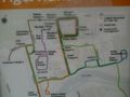
Shockingly, this map was useful.
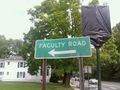
Students: no left turn
After a mile hike downhill....
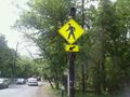
Pedestrian-activated warning lights at crossing, 3 to 5 times more effective than wildly waving your arms
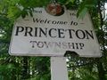
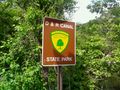
Princeton welcomes you! Please wipe your feet
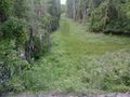
Do you see a trail here? I see flooding and a natural gas pipeline.
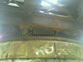
It's not a drawbridge, but the rail crossing has some sort of works underneath.
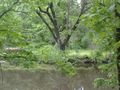
The geohash

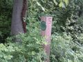
A geohasher
Either 10 miles or half a mile from something more interesting
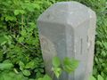
Based on which way the numbers face, it's 15 miles to Trenton, and 28 miles to New Brunswick YMMV.


Achievements
Jevanyn earned the 2011 Geohashing Day achievement
|