Difference between revisions of "2011-05-22 45 -121"
imported>Kydlt (Created page with " Today's hash is in a county park, next to Hood River, in the town of Hood River, just South of the Columbia River, about an hour and 1/2 East of the Willamette River. Anybody...") |
imported>FippeBot m (Location) |
||
| (11 intermediate revisions by 5 users not shown) | |||
| Line 1: | Line 1: | ||
| − | + | <!-- If you did not specify these parameters in the template, please substitute appropriate values for IMAGE, LAT, LON, and DATE (YYYY-MM-DD format) | |
| + | |||
| + | [[Image:{{{image|IMAGE}}}|thumb|left]] | ||
| + | |||
| + | Remove this section if you don't want an image at the top (left) of your report. You should remove the "Image:" or "File:" | ||
| + | tag from your image file name, and replace the all upper-case word IMAGE in the above line. | ||
| + | |||
| + | And DON'T FORGET to add your expedition and the best photo you took to the gallery on the Main Page! We'd love to read your report, but that means we first have to discover it! | ||
| + | --> | ||
| + | {{meetup graticule | ||
| + | | lat=45 | ||
| + | | lon=-121 | ||
| + | | date=2011-05-22 | ||
| + | }} | ||
| + | |||
| + | |||
| + | __NOTOC__ | ||
| + | == Location == | ||
| + | Tucker County Park, South of the town of Hood River. | ||
| + | |||
| + | == Participants == | ||
| + | * [[User:kydlt|kydlt]] | ||
| + | |||
| + | == Plans == | ||
| + | Going by myself. I plan to be there 1200 or 1300 & stay a little while. | ||
| + | |||
| + | |||
| + | == Expedition == | ||
| + | I had a nice drive, and it WAS sunny in Hood River. But Google lied, the hash was in or just across the Hood River. My GPS calculated it as 30 m away from me. It was private property on the other side, and the river was too fast, high and cold to wade today. | ||
| + | |||
| + | So a near miss, defeated again by the Northwest's wonderful, plentiful water. But I checked out a nice county park and bought some atlatal darts at Good Karma. | ||
| + | |||
| + | == Tracklog == | ||
| + | I have the log, now to figure out how to link to it. | ||
| + | |||
| + | == Photos == | ||
| + | |||
| + | <gallery perrow="5"> | ||
| + | Image:2011-05-22 45 -121 001 into Hood River.jpg | Rolling into Hood River. | ||
| + | Image:2011-05-22 45 -121 002 into Tucker Park.jpg | about 4 mi to Tucker Park. | ||
| + | Image:2011-05-22 45 -121 005 over there.jpg | The hash was just at the river's curve, but on the other side. | ||
| + | Image:2011-05-22 45 -121 005 TuckerParkscreen capture.JPG | Here is the TOPO USA imagery overlayed with my track. I find that the Google Map imagery is often about 100 ft off, compared to my GPS 'on the ground' experience. Does anyone else think this ? | ||
| + | Image:2011-05-22 45 -121 006 looking over trees.jpg | I was above the trees on a cliff about 30 m. away. | ||
| + | Image:2011-05-22 45 -121 007 straight down.jpg | And about 10 m. straight down. | ||
| + | Image:2011-05-22 45 -121 008 nice park.jpg | But I got to check out a nice little park to take the children camping to this summer. | ||
| + | Image:2011-05-22 45 -121 009 go to airport.jpg | I passed the airport coming and going. | ||
| + | Image:2011-05-22 45 -121 010 take a ride.jpg | But the sailplane's wings were off. The sign is the plane's road case. | ||
| + | Image:2011-05-22 45 -121 011 or go to the museum.jpg | This is a GREAT museum! | ||
| + | Image:2011-05-22 45 -121 012 but dont miss.jpg | And I always stop in here to get great stuff. | ||
| + | Image:2011-05-22 45 -121 013 the Good Karma Store.jpg | No relation or affiliation. Other than he holds stuff for me when he thinks I need it. | ||
| + | </gallery> | ||
| + | |||
| + | == Achievements == | ||
| + | {{#vardefine:ribbonwidth|800px}} | ||
| + | |||
| + | * MNB?? | ||
| + | |||
| + | |||
| + | [[Category:Expeditions]] | ||
| + | |||
| + | [[Category:Expeditions with photos]] | ||
| + | |||
| + | |||
| + | [[Category:Coordinates not reached]] | ||
| + | |||
| + | [[Category:Not reached - Mother Nature]] | ||
| + | {{location|US|OR|HO}} | ||
Latest revision as of 06:37, 9 August 2019
| Sun 22 May 2011 in 45,-121: 45.6495345, -121.5661950 geohashing.info google osm bing/os kml crox |
Location
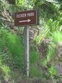
Tucker County Park, South of the town of Hood River.
Participants
Plans
Going by myself. I plan to be there 1200 or 1300 & stay a little while.
Expedition
I had a nice drive, and it WAS sunny in Hood River. But Google lied, the hash was in or just across the Hood River. My GPS calculated it as 30 m away from me. It was private property on the other side, and the river was too fast, high and cold to wade today.
So a near miss, defeated again by the Northwest's wonderful, plentiful water. But I checked out a nice county park and bought some atlatal darts at Good Karma.
Tracklog
I have the log, now to figure out how to link to it.
Photos
Rolling into Hood River.
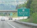
about 4 mi to Tucker Park.
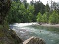
The hash was just at the river's curve, but on the other side.
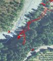
Here is the TOPO USA imagery overlayed with my track. I find that the Google Map imagery is often about 100 ft off, compared to my GPS 'on the ground' experience. Does anyone else think this ?
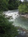
I was above the trees on a cliff about 30 m. away.
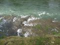
And about 10 m. straight down.
But I got to check out a nice little park to take the children camping to this summer.
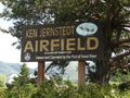
I passed the airport coming and going.

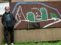
But the sailplane's wings were off. The sign is the plane's road case.

This is a GREAT museum!
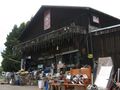
And I always stop in here to get great stuff.

No relation or affiliation. Other than he holds stuff for me when he thinks I need it.


Achievements
- MNB??