Difference between revisions of "2011-05-22 45 -121"
imported>Jiml m (MNB Ribbon??) |
imported>FippeBot m (Location) |
||
| (3 intermediate revisions by 3 users not shown) | |||
| Line 27: | Line 27: | ||
== Expedition == | == Expedition == | ||
| − | I had a nice drive, and it WAS sunny in Hood River. But | + | I had a nice drive, and it WAS sunny in Hood River. But Google lied, the hash was in or just across the Hood River. My GPS calculated it as 30 m away from me. It was private property on the other side, and the river was too fast, high and cold to wade today. |
So a near miss, defeated again by the Northwest's wonderful, plentiful water. But I checked out a nice county park and bought some atlatal darts at Good Karma. | So a near miss, defeated again by the Northwest's wonderful, plentiful water. But I checked out a nice county park and bought some atlatal darts at Good Karma. | ||
| Line 39: | Line 39: | ||
Image:2011-05-22 45 -121 001 into Hood River.jpg | Rolling into Hood River. | Image:2011-05-22 45 -121 001 into Hood River.jpg | Rolling into Hood River. | ||
Image:2011-05-22 45 -121 002 into Tucker Park.jpg | about 4 mi to Tucker Park. | Image:2011-05-22 45 -121 002 into Tucker Park.jpg | about 4 mi to Tucker Park. | ||
| − | Image:2011-05-22 45 -121 005 over there.jpg | The hash was just at the river's curve, but on the other side. | + | Image:2011-05-22 45 -121 005 over there.jpg | The hash was just at the river's curve, but on the other side. |
| + | Image:2011-05-22 45 -121 005 TuckerParkscreen capture.JPG | Here is the TOPO USA imagery overlayed with my track. I find that the Google Map imagery is often about 100 ft off, compared to my GPS 'on the ground' experience. Does anyone else think this ? | ||
Image:2011-05-22 45 -121 006 looking over trees.jpg | I was above the trees on a cliff about 30 m. away. | Image:2011-05-22 45 -121 006 looking over trees.jpg | I was above the trees on a cliff about 30 m. away. | ||
Image:2011-05-22 45 -121 007 straight down.jpg | And about 10 m. straight down. | Image:2011-05-22 45 -121 007 straight down.jpg | And about 10 m. straight down. | ||
| Line 64: | Line 65: | ||
[[Category:Not reached - Mother Nature]] | [[Category:Not reached - Mother Nature]] | ||
| + | {{location|US|OR|HO}} | ||
Latest revision as of 06:37, 9 August 2019
| Sun 22 May 2011 in 45,-121: 45.6495345, -121.5661950 geohashing.info google osm bing/os kml crox |
Location
Tucker County Park, South of the town of Hood River.
Participants
Plans
Going by myself. I plan to be there 1200 or 1300 & stay a little while.
Expedition
I had a nice drive, and it WAS sunny in Hood River. But Google lied, the hash was in or just across the Hood River. My GPS calculated it as 30 m away from me. It was private property on the other side, and the river was too fast, high and cold to wade today.
So a near miss, defeated again by the Northwest's wonderful, plentiful water. But I checked out a nice county park and bought some atlatal darts at Good Karma.
Tracklog
I have the log, now to figure out how to link to it.
Photos
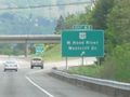
Rolling into Hood River.
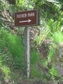
about 4 mi to Tucker Park.
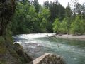
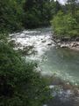
The hash was just at the river's curve, but on the other side.
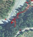
Here is the TOPO USA imagery overlayed with my track. I find that the Google Map imagery is often about 100 ft off, compared to my GPS 'on the ground' experience. Does anyone else think this ?
I was above the trees on a cliff about 30 m. away.
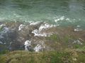
And about 10 m. straight down.
But I got to check out a nice little park to take the children camping to this summer.
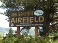
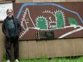
I passed the airport coming and going.

But the sailplane's wings were off. The sign is the plane's road case.

This is a GREAT museum!
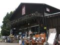
And I always stop in here to get great stuff.

No relation or affiliation. Other than he holds stuff for me when he thinks I need it.


Achievements
- MNB??